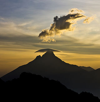
The Virunga Mountains are a chain of volcanoes in East Africa, in the area where Rwanda, the Democratic Republic of the Congo (DRC), and Uganda meet. The mountain range is a branch of the Albertine Rift Mountains, which border the western branch of the East African Rift. They are located between Lake Edward and Lake Kivu. The name "Virunga" is an English version of the Kinyarwanda word ibirunga, which means "volcanoes".

Volcanoes National Park is a national park in northwestern Rwanda. It covers 160 km2 (62 sq mi) of rainforest and encompasses five of the eight volcanoes in the Virunga Mountains, namely Karisimbi, Bisoke, Muhabura, Gahinga and Sabyinyo. It borders Virunga National Park in the Democratic Republic of Congo and Mgahinga Gorilla National Park in Uganda. It is home to the mountain gorilla and the golden monkey, and was the base for the primatologist Dian Fossey.

Virunga National Park is a national park in the Albertine Rift Valley in the eastern part of the Democratic Republic of the Congo. It was created in 1925. In elevation, it ranges from 680 m (2,230 ft) in the Semliki River valley to 5,109 m (16,762 ft) in the Rwenzori Mountains. From north to south it extends approximately 300 km (190 mi), largely along the international borders with Uganda and Rwanda in the east. It covers an area of 8,090 km2 (3,120 sq mi).

The Bwindi Impenetrable National Park is a national park in southwestern Uganda. It is part of the Bwindi Impenetrable Forest and is situated along the Democratic Republic of the Congo border next to the Virunga National Park and on the edge of the Albertine Rift. Composed of 321 km2 (124 sq mi) of both montane and lowland forest, it is accessible only on foot. It is a United Nations Educational, Scientific and Cultural Organization-designated World Heritage Site.
Kisoro is a town in the Western Region of Uganda. It is the chief town of Kisoro District and the site of the district headquarters.

Kigezi District once covered what are now Kabale District, Kanungu District, Kisoro District and Rukungiri District, in southwest Uganda. Its terraced fields are what gives this part of Uganda its distinctive character. Kigezi was popularly known as the Switzerland of Africa. The coordinates for the region are: Latitude:01 13 20S, 29 53 20E.

Mount Muhabura, also known as Mount Muhavura, is an inactive volcano in the Virunga Mountains on the Rwanda-Uganda border. At 4,127 metres (13,540 ft), Muhabura is the third highest of the eight major mountains of the mountain range, which is part of the Albertine Rift, the western branch of the East African Rift. Its summit contains a small crater lake. The limited evidence for this volcano suggests that it last erupted some time in the Holocene, but the exact date is not known. The Smithsonian Institution states that a small parasitic crater near Muhabura had been active recently. Muhabura is partly in the Volcanoes National Park, Rwanda and partly in the Mgahinga Gorilla National Park, Uganda.
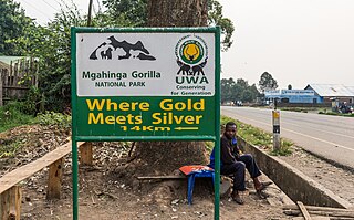
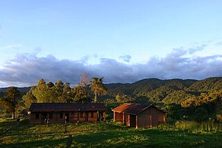
Mgahinga Gorilla National Park is a national park in southwestern Uganda. It was created in 1991 and covers an area of 33.9 km2 (13.1 sq mi).
Mount Gahinga is a dormant/extinct volcano in the Virunga Mountains on the Rwanda-Uganda border. Gahinga lies between Muhabura and Sabyinyo, but is the smallest of these three valcanoes. Mount Gahinga, also known in the local Kinyarwanda/Rufumbira dialect as "a small pile of stones", has a swampy caldera on its peak. The caldera is believed to be about 180 m (591 ft) wide. Mgahinga Gorilla National Park got its name from this volcano. Mount Gahinga, whose elevation is 3,473 m (11,394 ft), is part of a chain of eight volcanic mountains of the Mufumbiro ranges. The volcano chain spans across Uganda, Rwanda and the Democratic Republic of Congo.

The Albertine Rift is the western branch of the East African Rift, covering parts of Uganda, the Democratic Republic of the Congo (DRC), Rwanda, Burundi and Tanzania. It extends from the northern end of Lake Albert to the southern end of Lake Tanganyika. The geographical term includes the valley and the surrounding mountains.
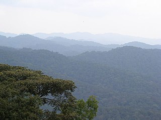
The Albertine Rift montane forests is a tropical moist broadleaf forest ecoregion in east-central Africa. The ecoregion covers the mountains of the northern Albertine Rift, and is home to distinct Afromontane forests with high biodiversity.

Semuliki National Park is a national park in Bwamba County, a remote part of the Bundibugyo District in the Western Region of Uganda that was established in October 1993. It encompasses 219 km2 (85 sq mi) of East Africa's only lowland tropical rainforest. It is one of the richest areas of floral and faunal biodiversity in Africa, with bird and butterfly species being especially diverse. The park is managed by the Uganda Wildlife Authority.
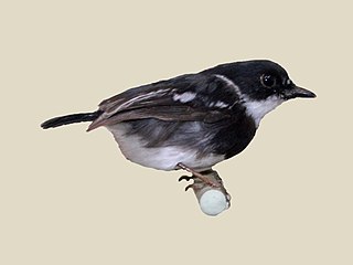
The Rwenzori batis is an endemic bird native to the Albertine Rift montane forests, where it inhabits altitudes of 1,340–3,300 m (4,400–10,830 ft).
The Institute of Tropical Forest Conservation (ITFC) is a post-graduate research institute based in the Bwindi Impenetrable Forest, in south-western Uganda. The institute is a semi-autonomous part of Mbarara University of Science and Technology and is focused on research, training, and monitoring for conservation management in the Albertine Rift ecoregion.

Lake Mutanda is a small freshwater lake in Uganda.
The Bwindi Impenetrable Forest is a large primeval forest located in south-western Uganda and is located in three districts of Kisoro, Kabale and Kanungu. The Bwindi forest is on the edge of the Albertine Rift, the western branch of the East African Rift, at elevations ranging from 1,160 to 2,607 metres. The forest contains around 160 species of trees and over 100 species of ferns.Bwindi Impenetrable Forest Reserve was set up in 1942 on the rim of the Rift Valley.

The International Gorilla Conservation Programme was formed in 1991 to ensure that the critically endangered mountain gorillas are conserved in their habitat in the mountain forests of the Virunga Massif in Rwanda, Uganda and the Democratic Republic of the Congo.
The Itombwe Mountains are a range of mountains in the South Kivu province of the Democratic Republic of the Congo (DRC). They run along the west shore of the northern part of Lake Tanganyika. They contain a vast area of contiguous montane forest and are home to a rich diversity of wildlife.
Echuya Batwa, commonly known as pygmies, are an endangered group of people around Echuya Forest Reserve in Kisoro and Kabale Districts of South-Western Uganda. The Echuya is located in the Albertine Rift region recognized as an important eco-region. The Batwa are believed to have migrated from the Ituri Forest of the Democratic Republic of Congo in search of wild animals to hunt, hence the name Kisoro, literally meaning "the area occupied by wild animals". The Batwa live in small huts mainly made from sticks and grass, and number 6,700 per a 2014 estimate by the Uganda Bureau of Statistics.

The Ruwenzori-Virunga montane moorlands is a montane grasslands and shrublands ecoregion of the Rwenzori Mountains and Virunga Mountains in central Africa.

