Kisoro

Last updated
Kisoro
Gisoro
Uganda location map.svg
Red pog.svg
Kisoro
Location in Uganda
Coordinates: 01°17′06″S29°41′06″E / 1.28500°S 29.68500°E / -1.28500; 29.68500
Country Flag of Uganda.svg Uganda
Region Western Region of Uganda
Sub-region Kigezi sub-region
District Kisoro District
Government
  Chairman LC5 Bizimana Abel [ citation needed ]
Elevation
6,329 ft (1,929 m)
Population
 (2014 Census)
  Total17,561 [1]
Time zone East Africa Time
Climate Cfb

Kisoro is a town in the Western Region of Uganda. It is the chief town of Kisoro District and the site of the district headquarters.

Contents

Location

Kisoro is approximately 76 kilometres (47 mi), by road, west of Kabale, the largest city in the Kigezi sub-region. [2] This is approximately 484 kilometres (301 mi), by road, southwest of Kampala, the capital of Uganda and the country's largest city. [3] Kisoro is east of Rumangabo and the Virunga Mountains in the Democratic Republic of the Congo (DRC). The geographical coordinates of Kisoro are 1°17'06.0"S, 29°41'06.0"E (Latitude:-1.2850; Longitude:29.6850). [4] Kisoro Town Council sits at an average elevation of 1,929 metres (6,329 ft), above mean sea level. [5]

Overview

Kisoro is located under the peaks of the Mufumbiro Mountains, which are part of the Virunga Mountains and home to rare mountain gorillas. Mountain scenery, Lake Mutanda, colorful markets, and volcano trekking also are available for visitors to Kisoro. It is the nearest town to the Mgahinga Gorilla National Park and is an access town for those traveling to Rwanda or the DRC for gorilla tracking in the Volcanoes National Park or the Virunga National Park. [6]

Population

The 2002 national census estimated the population of Kisoro at 11,330. The Uganda Bureau of Statistics (UBOS) estimated the population at 12,700 in 2010. In 2011, UBOS estimated the mid-year population at 12,900. [7] In 2014, the national population census estimated the population at 17,561. [1]

Points of interest

The following additional points of interest are located within the town limits or near its edges:

Photos

See also

Related Research Articles

<span class="mw-page-title-main">Bwindi Impenetrable National Park</span> National park in Uganda

The Bwindi Impenetrable National Park (BINP) is in southwestern Uganda. The park is part of the Bwindi Impenetrable Forest and is situated along the Democratic Republic of the Congo (DRC) border next to the Virunga National Park and on the edge of the Albertine Rift. Composed of 321 square kilometres (124 sq mi) of both montane and lowland forest, it is accessible only on foot. BINP is a United Nations Educational, Scientific and Cultural Organization-designated World Heritage Site.

<span class="mw-page-title-main">Kabale District</span> District in Western Region, Uganda

Kabale District is a district in the Western Region of Uganda. Kabale hosts the district headquarters. It was originally part of Kigezi District, before the districts of Rukungiri, Kanungu, Kisoro, Rubanda and Rukiga and were excised to form separate districts. Kabale is sometimes nicknamed "Kastone" as in the local language Rukiga, a "kabale" is a small stone.

<span class="mw-page-title-main">Kanungu District</span> District in Western Region, Uganda

Kanungu District is a district in the Western Region of Uganda. The town of Kanungu is the site of the district headquarters. The Bwindi Impenetrable Forest in Kanungu District is among the sites shown in aerial footage in the movie Black Panther.

<span class="mw-page-title-main">Kisoro District</span> District in Western Region, Uganda

Kisoro District is a district in the Western Region of Uganda. The town of Kisoro is the site of the district headquarters.

<span class="mw-page-title-main">Kabale</span> Place in Western Region of Uganda, Uganda

Kabale is a town in the Western Region of Uganda. It is the chief town of Kabale District, and the district headquarters are located there.

<span class="mw-page-title-main">Bundibugyo</span> Town in Uganda

Bundibugyo is a town in the Western Region of Uganda. It is the 'chief town' of Bundibugyo District and the district headquarters are located there.

<span class="mw-page-title-main">Kigezi District</span> Former district in Uganda

Kigezi District once covered what are now Kabale District, Kanungu District, Kisoro District and Rukungiri District, in southwest Uganda. Its terraced fields are what gives this part of Uganda its distinctive character. Kigezi was popularly known as the Switzerland of Africa. The coordinates for the region are: Latitude:01 13 20S, 29 53 20E.

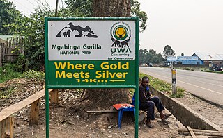
Mgahinga Gorilla National Park is a national park in southwestern Uganda. It was created in 1991 and covers an area of 33.9 km2 (13.1 sq mi).

Rukungiri is a town in Rukungiri District of the Western Region of Uganda. It is the site of the district headquarters.

Mpondwe is a town in the Western Region of Uganda.

<span class="mw-page-title-main">Lake Mutanda</span>

Lake Mutanda is a small freshwater lake in Uganda.

Bunagana is a town in the Western Region of Uganda. It sits across the international border from the similarly named town of Bunagana, Democratic Republic of the Congo.

Kigezi High School, is a mixed, boarding high school in Kabale, Kabale District, Western Uganda.

Sanga, is an urban center in the Kiruhura District, Ankole sub-region, in the Western Region of Uganda.

Kabale–Kisoro–Bunagana Road is a road in Western Uganda, connecting the towns of Kabale with the towns of Kisoro, Bunagana, at the border with the Democratic Republic of the Congo and Kyanika at the border with Rwanda.

Kyanika is a settlement in Kisoro District in the Western Region of Uganda.

<span class="mw-page-title-main">Rubanda District</span> District in Western Region, Uganda

Rubanda District is a district in the Western Region of Uganda. The largest town in the district, Rubanda, serves as the main administrative and commercial center in the district.

Rubanda is a town in the extreme southwest of the Western Region of Uganda. It serves as the commercial, political and administrative center of Rubanda District.

Bugongi is a neighborhood in the town of Kabale, the largest urban center and district headquarters of Kabale District in Uganda.

Busengo is a settlement in the Western Region of Uganda. It is one of the urban centers in Kisoro District. The town lies across the international border from Busengo, Democratic Republic of the Congo.

References

  1. 1 2 UBOS (29 November 2014). "The Population of The Regions of the Republic of Uganda And All Cities And Towns of More Than 15,000 Inhabitants". Citypopulation.de Quoting Uganda Bureau of Statistics (UBOS). Retrieved 28 February 2015.
  2. Google (22 August 2021). "Road Distance Between Kabale, Uganda And Kisoro, Uganda" (Map). Google Maps . Google. Retrieved 22 August 2021.
  3. Google (22 August 2021). "Road Distance Between Kampala, Uganda And Kisoro, Uganda With Map" (Map). Google Maps . Google. Retrieved 22 August 2021.
  4. Google (22 August 2021). "Location of Kisoro, Uganda" (Map). Google Maps . Google. Retrieved 22 August 2021.
  5. Elevation Maplogs (22 August 2021). "Worldwide Elevation Finder". Elevation.maplogs.com. Retrieved 22 August 2021.
  6. UTP. "Overview of Kisoro Town, Uganda". Uganda Travel Planner (UTP). Archived from the original on 28 May 2014. Retrieved 7 June 2014.
  7. UBOS. "Estimated Population of Kisoro In 2002, 2010 And 2011" (PDF). Uganda Bureau of Statistics (UBOS). Archived from the original (PDF) on 7 July 2014. Retrieved 7 June 2014.

01°17′06″S29°41′06″E / 1.28500°S 29.68500°E / -1.28500; 29.68500