


The Katonga River is a river in Uganda, in East Africa.
The Katonga River is a river in Uganda, in East Africa.
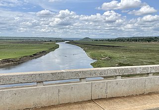
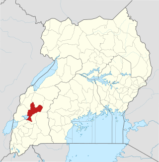
The Katonga River is located in the southwestern part of Uganda. Its channel is continuous between Lake Victoria and Lake George, reflecting that it once drained away from Lake Victoria into Lake George along its entire length. Regional uplifting events between the two lakes associated with the western limb (Albertine Rift) of the geologically active East African Rift system, has caused the swampy region to the southwest of Lake Wamala to become the new watershed for the Katonga River, which now principally flows east into Lake Victoria, augmented by several tributaries along its course. This watershed is located approximately 0°13'N 30°39'E near the Katonga Wildlife Reserve, and at a distance of more than 120 km from Lake Victoria. During wet seasons, raised water levels in the vicinity of its swampy watershed will occasionally force some water to flow west from this point into the western section of the Katonga River which feeds Lake George, but the bulk of the flow still continues eastwards into Lake Victoria. West of its watershed, the Katonga River is also fed by several tributaries along its course to Lake George. [1]

The Nile is a major north-flowing river in northeastern Africa. It flows into the Mediterranean Sea. The Nile is the longest river in Africa and has historically been considered the longest river in the world, though this has been contested by research suggesting that the Amazon River is slightly longer. Of the world's major rivers, the Nile is one of the smallest, as measured by annual flow in cubic metres of water. About 6,650 km (4,130 mi) long, its drainage basin covers eleven countries: the Democratic Republic of the Congo, Tanzania, Burundi, Rwanda, Uganda, Kenya, Ethiopia, Eritrea, South Sudan, Sudan, and Egypt. In particular, the Nile is the primary water source of Egypt, Sudan and South Sudan. Additionally, the Nile is an important economic river, supporting agriculture and fishing.

Tanzania comprises many lakes, national parks, and Africa's highest point, Mount Kilimanjaro. Northeast Tanzania is mountainous, while the central area is part of a large plateau covered in grasslands. The country also contains the southern portion of Lake Victoria on its northern border with Uganda and Kenya.

The Zambezi is the fourth-longest river in Africa, the longest east-flowing river in Africa and the largest flowing into the Indian Ocean from Africa. Its drainage basin covers 1,390,000 km2 (540,000 sq mi), slightly less than half of the Nile's. The 2,574 km (1,599 mi) river rises in Zambia and flows through eastern Angola, along the north-eastern border of Namibia and the northern border of Botswana, then along the border between Zambia and Zimbabwe to Mozambique, where it crosses the country to empty into the Indian Ocean.

The White Nile is a river in Africa, the minor of the two main tributaries of the Nile, the larger being the Blue Nile. The name "White" comes from the clay sediment carried in the water that changes the water to a pale color.
The Aruwimi River is a tributary of the Congo River, located to the north and east of the Congo.

The Cuando River is a river in south-central Africa flowing through Angola and Namibia's Caprivi Strip and into the Linyanti Swamp on the northern border of Botswana. Below the swamp, the river is called the Linyanti River and, farther east, the Chobe River, before it flows into the Zambezi River.

The 1,576 kilometres (979 mi) long Kafue River is the longest river lying wholly within Zambia. Its water is used for irrigation and for generating hydroelectric power. It is the largest tributary of the Zambezi, and of Zambia's principal rivers, it is the most central and the most urban. More than 50% of Zambia's population live in the Kafue River Basin and of these around 65% are urban.

The Ruzizi is a river, 117 kilometres (73 mi) long, that flows from Lake Kivu to Lake Tanganyika in Central Africa, descending from about 1,500 metres (4,900 ft) to about 770 metres (2,530 ft) above sea level over its length. The steepest gradients occur over the first 40 kilometres (25 mi), where hydroelectric dams have been built. Further downstream, the Ruzizi Plain, the floor of the Western Rift Valley, has gentle hills, and the river flows into Lake Tanganyika through a delta, with one or two small channels splitting off from the main channel.

The Albertine Rift is the western branch of the East African Rift, covering parts of Uganda, the Democratic Republic of the Congo (DRC), Rwanda, Burundi and Tanzania. It extends from the northern end of Lake Albert to the southern end of Lake Tanganyika. The geographical term includes the valley and the surrounding mountains.
The Malagarasi River is a river in western Tanzania, flowing through Kigoma Region, although one of its tributaries comes from southeastern Burundi. The river also forms the western border of Tabora Region, the southern border of Kagera Region and the southwestern border of Geita Region. It is the second-longest river in Tanzania behind the Rufiji—Great Ruaha, and has the largest watershed of any river flowing into Lake Tanganyika. The Malagarasi-Muyovozi Wetlands are a designated a Ramsar site. Local tribes have nicknamed the Malagarasi as "the river of bad spirits".

The Bill Williams River is a 46.3-mile-long (74.5 km) river in west-central Arizona where it, along with one of its tributaries, the Santa Maria River, form the boundary between Mohave County to the north and La Paz County to the south. It is a major drainage westwards into the Colorado River of the Lower Colorado River Valley south of Hoover Dam and Lake Mead, and the drainage basin covers portions of northwest, and west-central Arizona. The equivalent drainage system paralleling the east–west lower reaches of the Bill Williams is the Gila River, which flows east-to-west across central Arizona, joining the Colorado River in the southwest at Yuma. The confluence of the Bill Williams River with the Colorado is north of Parker, and south of Lake Havasu City.
The Katonga Wildlife Reserve is a wildlife reserve in western Uganda, along the banks of the Katonga River. The reserve was established in 1998 and has approximately 211 square kilometres (81 sq mi). Many of the species of plants and animals in the reserve are unique to its wetland environment. Additionally the grass species at Katonga Wildlife Reserve include star grass, Bermuda grass and Rhodes grass.
Nkozi is a town in central Uganda. It is one of the urban centers in Mpigi District.

The Nyabarongo is a major river in Rwanda, part of the upper headwaters of the Nile. With a total length of 351 km (218 mi), it is the longest river entirely in Rwanda. It is extended 421 km (262 mi) in Lake Rweru including a 69 km (43 mi) upper course of Kagera River before joining into Ruvuvu River to form the Kagera River. The river begins its course at the confluence of the rivers Mbirurume and Mwogo in the South West of the country. These two rivers themselves begin in Nyungwe Forest, and are considered by some to be the most distant source of the Nile. From its start, Nyabarongo flows northward for 85 km, and forms the border between the Western and Southern Provinces. At the confluence with the river Mukungwa, the river changes course and flows eastward for 12 km, then to a more South Eastern course for the last 200 km. For the longest stretch of this course, the river serves as the boundary between the Northern and Southern Provinces, then between the City of Kigali and the Southern Province, and lastly between the City of Kigali and the Eastern Province.

3°48′43″S35°53′20″E — River mouth

The Congo–Nile Divide or the Nile–Congo Watershed is the continental divide that separates the drainage basins of the Congo and Nile rivers. It is about 2,000 kilometres (1,200 mi) long.

Lubigi is a swampy wetland on the northern and western outskirts of Kampala, the capital and largest city of Uganda.
The geology of Uganda extends back to the Archean and Proterozoic eons of the Precambrian, and much of the country is underlain by gneiss, argillite and other metamorphic rocks that are sometimes over 2.5 billion years old. Sedimentary rocks and new igneous and metamorphic units formed throughout the Proterozoic and the region was partially affected by the Pan-African orogeny and Snowball Earth events. Through the Mesozoic and Cenozoic, ancient basement rock has weathered into water-bearing saprolite and the region has experienced periods of volcanism and rift valley formation. The East Africa Rift gives rise to thick, more geologically recent sediment sequences and the country's numerous lakes. Uganda has extensive natural resources, particularly gold.
Bihanga is a settlement in Ibanda District in the Western Region of Uganda. It is the location of the headquarters of Bihanga Parish, Nyamarebe sub-county.
Kitagwenda District is a district in Western Uganda. The district is named after Kitagwenda County, which is coterminous with the district.