Based on figures from the Central Statistical Agency in 2005, Gish Abay has an estimated total population of 3,385 of whom 1,615 are men and 1,770 are women.[1] The 1994 census reported this town had a total population of 1,959 of whom 850 were men and 1,109 were women.
Source of the Blue Nile
Gish Abay is best known as the source of the Abay, or Blue Nile, also known as Felege Ghion in Ge'ez, the liturgical language of Ethiopia. In scientific logic based on river basin, the source of Abay (the blue Nile) is Lake Tana. it is basically because the water volume that inters in to lake Tana from Gilgel Abay, Picolo Abay is only one third of the water volume that leaves Lake Tana at the outlet as there are more than 60 rivers that enter into lake Tana among which 5 rivers including Gilgel Abay holds 93% of the Abay river at the outlet of Lake Tana. In which the rest four rivers other than Gilgel Abay originates from Gonder Province. Above all the small springs at Gish-Abay town are by far smaller than the other rivers that join the small spring discharges from Gish-Abay Abay, for example Kelti river from Agew-Awi zone is by far larger than the three springs discharge at Gish-Abay town. Its only the catholic priest Pedro Paez, who described it as the source of Abay on his religious mission to preach Catholic to the orthodox Christians for acceptance by the local people. Felege Ghion consists of three small springs found within a diameter of about 20 meters. These waters are believed to have a healing power and considered holy by the Ethiopian Church. The first European recorded as having visited the source of Blue Nile at Gish Abay is Pedro Páez, a Spanish missionary, who arrived at these springs 21 April 1618. In the 18th century, the culture and religion of the local people of Gish Abay was chronicled in detail by the 18th century explorer, James Bruce. The British Consul Robert Cheesman was one of the later discoverers who published a geographical description of the area.[2] A more recent expedition is made by a group of American navigators who navigate the river from its source at Gish to the Mediterranean Sea, led by geologist Pasquale Scaturro, whose adventure was related in the film Mystery of the Nile.
About 100 meters north of the source of Abay is the church of Gish Abay Felege Ghion Abune Zerabruk Monastery, which has been one of the most respected centers for church education over the past centuries. Although local inhabitants believe the monastery was founded in the 17th century by a local saint called Abune Zerabruk, whose memory is honored with a celebration at the church each year on Tir 13 (January 20), Cheesman speculated that the name of the saint is a corruption of the explorer James Bruce.[2] There is also another church in the town, dedicated to Saint Mary, with considerable spiritual significance. Together with other sites in Sekela woreda, like Fasildes Castle and Lake Gudera, Gish Abay is now identified as a notable tourist destination in Gojjam.[citation needed]
History
The town is founded in a place called Yideb, a mountainous area where Italian occupation forces fortified during the Second Italo-Abyssinian War. During the war, the Italian fort was under constant attack from the local Arbegnoch groups, most notably Dejazmach Zelleke Desta, and the Italians left the fort before the arrival of Haile Selassie and British forces. Then, the area was used as a base for the liberation forces, which attracted the local people to settle at Yideb. The settlement led to the foundation of Gish Abay which soon became an important market center for cereals and cattle. Its development continued until the lack of suitable space on the mountainous area of Yideb limited further expansion, and led in 1987 to the town being re-established at a location much closer to Mount Gish and the source of Abay.[citation needed]
Modern education was introduced in 1952 with the opening of Dejazmach Zelleke Desta Elementary School. Now there are another two schools serving the town: the Gish Abay Elementary and Junior High School, and the Abay Minch Secondary and Preparatory High School. The town is connected by a 39km gravel road to Tilili, which is located on the main Addis Ababa-Debre Marqos-Bahir Dar road. Another road, which will connect Gish Abay to Adet is also under construction, which will make the distance with Bahir Dar less than 100km.[citation needed]
Lake Tana is the largest lake in Ethiopia and a source of the Blue Nile. Located in Amhara Region in the north-western Ethiopian Highlands, the lake is approximately 84 kilometres long and 66 kilometres wide, with a maximum depth of 15 metres, and an elevation of 1,788 metres. Lake Tana is fed by the Gilgel Abay, Reb and Gumara rivers. Its surface area ranges from 3,000 to 3,500 square kilometres, depending on season and rainfall. The lake level has been regulated since the construction of the control weir where the lake discharges into the Blue Nile. This controls the flow to the Blue Nile Falls and hydro-power station.
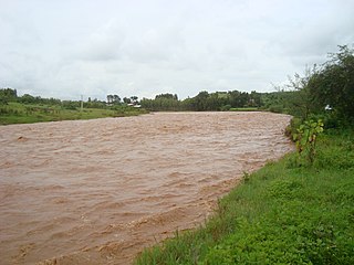
The Blue Nile is a river originating at Lake Tana in Ethiopia. It travels for approximately 1,450 km (900 mi) through Ethiopia and Sudan. Along with the White Nile, it is one of the two major tributaries of the Nile and supplies about 85.6% of the water to the Nile during the rainy season.
Gojjam is a historical provincial kingdom in northwestern Ethiopia, with its capital city at Debre Marqos.
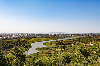
Bahir Dar is the capital city of Amhara Region, Ethiopia. Bahir Dar is one of the leading tourist destinations in Ethiopia, with a variety of attractions in the nearby Lake Tana and Blue Nile river. The city is known for its wide avenues lined with palm trees and a variety of colorful flowers. In 2002, it was awarded the UNESCO Cities for Peace Prize for addressing the challenges of rapid urbanization.
The Amhara Region, officially the Amhara National Regional State, is a regional state in northern Ethiopia and the homeland of the Amhara, Awi, Xamir, Argoba, and Qemant people. Its capital is Bahir Dar which is the seat of the Regional Government of Amhara. Amhara is the site of the largest inland body of water in Ethiopia, Lake Tana, and Semien Mountains National Park. Amhara is bordered by Sudan to the west and northwest and by other the regions of Ethiopia: Tigray to the north, Afar to the east, Benishangul-Gumuz to the west and southwest, and Oromia to the south. Towns and cities in Amhara include: Bahir Dar, Dessie, Gonder, Debre Birhan, Debre Tabor, Kombolcha, Weldiya, Debre Markos, Seqota, Kobo, and Metema.
The Blue Nile Falls is a waterfall on the Blue Nile river in West Gojjam, Amhara Region, Ethiopia. It is known as Tis Abay in Amharic, meaning 'great smoke'. It is situated on the upper course of the river, about 30 kilometres (19 mi) downstream from the town of Bahir Dar and Lake Tana. The falls are one of Ethiopia's best-known tourist attractions.
Baso Liben is one of the woredas in the Amhara Region of Ethiopia. A triangular-shaped district at the southernmost point of the Misraq Gojjam Zone, Baso Liben is bordered on the south by a bend of the Blue Nile river which separates it from the Oromia Region, on the northwest by the Chamwaga river which separates it from Gozamn, and on the northeast by Aneded. The major town in Baso Liben is Yejube. there are two other small towns; Kork and Yelamgeji with significant trading activity
Achefer was a woreda in Amhara Region, Ethiopia. It was named for the historic district of Achefer, which was first mentioned in the 16th century. Part of the Mirab Gojjam Zone, Achefer was bordered on the south by the Agew Awi Zone, on the west by the Semien Gondar Zone, on the north by Lake Tana, on the northeast by Bahir Dar Zuria, and on the southeast by Merawi; the Lesser Abay River defined the woreda's eastern boundary. The woreda included Dek Island. The administrative center was Yesmala; other towns in Achefer included Durbete, Liben, Kunzela, Chiba and Wandege. Acheref was divided for Debub Achefer and Semien Achefer woredas.
Bahir Dar Zuria is a woreda in Amhara Region, Ethiopia. Part of the Mirab Gojjam Zone, this woreda is bordered on the south by Yilmana Densa, on the southwest by Mecha, on the northwest by the Gilgel Abay River which separates it from Semien Achefer, on the north by Lake Tana, on the shores of Lake Tana situates the city and special zone of Bahir Dar, and on the east by the Abay River which separates it from the Debub Gondar Zone.
Mecha is a woreda in Amhara Region, Ethiopia. The name, Mecha, is taken from the name for a subdivision of the province of Gojjam. Part of the Mirab Gojjam Zone, Mecha is bordered on the south by Sekela, on the southwest by the Agew Awi Zone, on the west by the Lesser Abay River which separates it from Debub Achefer and Semien Achefer, on the northeast by Bahir Dar Zuria, and on the east by Yilmana Densa. Towns in Mecha include Merawi and Wetet Abay.
Sekela is one of the woredas in the Amhara Region of Ethiopia. Part of the West Gojjam Zone, Sekela is bordered on the southwest by Bure, on the west by the Agew Awi Zone, on the north by Mecha, on the northeast by Yilmana Densa, on the east by Kuarit, and on the southeast by Jabi Tehnan. The administrative center of Sekela is Gish Abay.
Quarit is one of the woredas in the Amhara Region of Ethiopia. Part of the Mirab Gojjam Zone, Quarit is bordered on the southwest by Jabi Tehnan, on the west by Sekela, on the north by Yilmana Densa, on the east by the Misraq Gojjam Zone, and on the southeast by Dega Damot. The major town in Quarit is Gebeze Mariam. Goncha woreda was separated from Quarit.
Dek Island is the biggest island on Lake Tana in Ethiopia. It is administratively included in the Bahir Dar Zuria woreda of the Mirab Gojjam Zone. To the southeast of Dek is the much smaller Daga Island.
Bure, also transliterated Burye is a town in western Ethiopia. Located in the Mirab Gojjam Zone of the Amhara Region, this town has a longitude and latitude of 10°42′N37°4′E with an elevation of 2091 meters above sea level.
Dengel Ber is a town in western Ethiopia. Located on the south-western shore of Lake Tana in the Semien Gondar Zone of the Amhara Region, this town has a latitude and longitude of 11°57′N37°00′E. Access to this town includes track roads to both Shawra and Kunzela and weekly service by the Bahir Dar-Gorgora ferry on Lake Tana. While the name of the town is indisputably Amharic, there is some disagreement over the meaning of its name: while "Pass of the Virgin" has been the most common interpretation since at least the days James Bruce visited Ethiopia, Huntingford and Beckingham state that it means "pass of canna plants".
Semien Achefer is a woreda in Amhara Region, Ethiopia. It is named for the historic district of Achefer, which was first mentioned in the 16th century. Part of the Mirab Gojjam Zone, Achefer is bordered on the south by Debub Achefer, on the west by the Semien Gondar Zone, on the north by Lake Tana, on the east by Bahir Dar Zuria, and on the southeast by Mecha; the Lesser Abay River defines the Woreda's eastern boundary. The woreda includes Dek Island. The administrative center is liben Town; other towns in Semien Achefer include Yesmala, Dembola, Sankira, Kunzila and Chimnba. Semien Achefer was part of former Achefer woreda before 1998 E.C. In this woreda Beles hydroelectric power generating station is found at Charman Dusuman kebele( water source of intake is from Lake Tana). Historical places in the woreda are Etege Mintewab Launched Palace( but now is not protected) at Kunzila zuria kebele, Gashola st. George Orthodox monastery at Gashola kebele, Abe Gubegna etc.
Bure is one of the woredas in the West Gojjam Zone of the Amhara Region of Ethiopia. Its name comes from its largest town, Bure. Part of the Mirab Gojjam Zone, Bure is bordered on the south by the Abay River which separates it from the Oromia Region, on the west by Wemberma, on the northwest by the Agew Awi Zone, on the north by Sekela, on the east by Jabi Tehnan, and on the southeast by Dembecha and the Misraq Gojjam Zone. Bure was part of former Bure Wemberma woreda.
The Zege Peninsula is a peninsula located on the southern shore of Lake Tana in Ethiopia, the largest lake in Ethiopia and the source of the Blue Nile river, and is situated at. It is 600 km northwest of Addis Ababa, the capital city of Ethiopia. It is considered an area sacred to the Ethiopian Orthodox Tewahedo Church, boasting multiple historical monasteries. In contrast to the arable farmland region around it, the Zege peninsula is notable for its dense coffee forest. This originates from a religious prohibition in the area on cutting trees, ploughing land, and raising large beasts.
The Gilgel Abay, or Lesser Abay, is a river of central Ethiopia. Rising in the mountains of Gojjam, it flows northward to empty into south-western Lake Tana at 11°48′N37°7′E. Tributaries of the Gilgel Abbay include the Ashar, Jamma, Kelti and the Koger. It was regarded as the true source of the Nile for a long time and the Jesuit priest Pedro Paez visited it in 1618. The name Gilgel Abbay means Lesser Nile, as Abbay is the name for the Blue Nile.
Bahir Dar is the capital city of the Amhara Region in Ethiopia.
This page is based on this Wikipedia article Text is available under the CC BY-SA 4.0 license; additional terms may apply. Images, videos and audio are available under their respective licenses.