| Wadi Howar | |
|---|---|
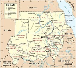 Map of Sudan (after 2011) | |
| Physical characteristics | |
| Mouth | Nile |
• coordinates | 18°11′56″N30°44′26″E / 18.19889°N 30.74056°E |
Wadi Howar (Wadi Howa or Yellow Nile) is a wadi in Sudan and Chad.
| Wadi Howar | |
|---|---|
| Map of Sudan (after 2011) | |
| Physical characteristics | |
| Mouth | Nile |
• coordinates | 18°11′56″N30°44′26″E / 18.19889°N 30.74056°E |
Wadi Howar (Wadi Howa or Yellow Nile) is a wadi in Sudan and Chad.
Originating in the Ennedi Region of Chad Wadi Howar runs through the Sudanese states of North Darfur and Northern to join the Nile north of the great bend opposite Old Dongola. Stretching over 1100 km [1] : 25 in west–east direction across the southern fringes of the Libyan Desert, it ordinarily receives 25 mm of rainfall per year. [2]

Wadi Howar is the remnant of the ancient Yellow Nile, a tributary of the Nile during the Neolithic Subpluvial from about 9500 to 4500 years ago. At that time Savanna fauna and cattle-herders occupied this region and the southern edge of the Sahara was some 500 km further north than it is today. [2] When the Sahara underwent desertification between 6000 and 4000 years ago, the wadi first became a chain of freshwater lakes and marshes, as shown by Ptolemy's world map, then it became extinct about 2000 years ago. [1] : 28
Abundant prehistoric sites certify Wadi Howar as a once ecologically favoured area of settlement and a communication route between the inner regions of Africa and the Nile Valley. [1] : 31 The hitherto most thoroughly investigated archaeological site in the wadi is Gala Abu Ahmed.

The geography of Egypt relates to two regions: North Africa and Southwest Asia.

The Nile is a major north-flowing river in northeastern Africa. It flows into the Mediterranean Sea. The Nile is the longest river in Africa and has historically been considered the longest river in the world, though this has been contested by research suggesting that the Amazon River is slightly longer. Of the world's major rivers, the Nile is one of the smallest, as measured by annual flow in cubic metres of water. About 6,650 km (4,130 mi) long, its drainage basin covers eleven countries: the Democratic Republic of the Congo, Tanzania, Burundi, Rwanda, Uganda, Kenya, Ethiopia, Eritrea, South Sudan, Republic of the Sudan, and Egypt. In particular, the Nile is the primary water source of Egypt, Sudan and South Sudan. Additionally, the Nile is an important economic river, supporting agriculture and fishing.


The Sahara is a desert on the African continent. With an area of 9,200,000 square kilometres (3,600,000 sq mi), it is the largest hot desert in the world and the third-largest desert overall, smaller only than the deserts of Antarctica and the northern Arctic.

Trans-Saharan trade requires travel across the Sahara between sub-Saharan Africa and North Africa. While existing from prehistoric times, the peak of trade extended from the 8th century until the early 17th century. The Sahara once had a very different environment. In Libya and Algeria, from at least 7000 BC, there was pastoralism, the herding of sheep, goats, large settlements, and pottery. Cattle were introduced to the Central Sahara (Ahaggar) from 4000 to 3500 BC. Remarkable rock paintings in places that are currently very dry, portray flora and fauna that are not present in the modern desert environment.

The Bayuda Desert, located at 18°N33°E, is in the eastern region of the Sahara Desert, spanning approximately 100,000 km2 of northeast Sudan north of Omdurman and south of Korti, embraced by the great bend of the Nile in the north, east and south and limited by the Wadi Muqaddam in the west. The north to south aligned Wadi Abu Dom divides the Bayuda Desert into the eastern Bayuda Volcanic Field and the western ochre-coloured sand-sheets scattered with rocky outcrop.
The Daju people are a group of seven distinct ethnicities speaking related languages living on both sides of the Chad-Sudan border and in the Nuba Mountains. Separated by distance and speaking different languages, at present, they generally have little cultural affinity to each other.
Ouaddaï Highlands is an area in east of Chad along the border with Sudan. The Ennedi Plateau and the Ouaddaï highlands in the east of Chad complete the image of a gradually sloping basin, which descends towards Lake Chad. There are also central highlands in the Guera region rising to 1,500 m (4,921 ft).

The Sudans is a region in Northeast Africa comprising the sovereign countries of Sudan and South Sudan. Until 2011, the region was united under a state known as the Republic of the Sudan.

Stefan Kröpelin is a geologist and climate researcher at the University of Cologne who specializes in studying the eastern Sahara desert and its climatic history. In 2017, he was awarded with the Communicator Award of the Deutsche Forschungsgemeinschaft for the excellent communication of his research both in Germany and international.

The Cave of the Beasts is a huge natural rock shelter in the Western Desert of Egypt featuring Neolithic rock paintings, more than 7,000 years old, with about 5,000 figures.

The Sabu-Jaddi rock art site in Sudan is a unique cluster of more than 1600 rock drawings from different historical periods expanding for more than 6000 years through different eras of Nubian civilization. however, exactly when the people living in this region began creating these images is still unknown. The site is located 600 km north of Khartoum between the villages of Sabu and Jaddi. The well-preserved drawings include wild and domestic animals, humans and boats.
Wadi Muqaddam is a dry water course some 320 km extending from beyond Omdurman north to the great bend of the Nile near Korti. It gives its name to the geological Wadi Milk Formation. Delimiting the Bayuda Desert to the west it still flows during rainy seasons. Some scholars assume Wadi Muqaddam as a former channel of the White Nile.

Wadi Al-Malik is the bed of an extinct river in Sudan. Following the Central African Shear Zone, it stretches for 560 km from the lake of Umm Badr in North Kurdufan NE-trending to the great bend of the Nile near Al Dabbah. It gives its name to the geological Wadi Milk Formation.
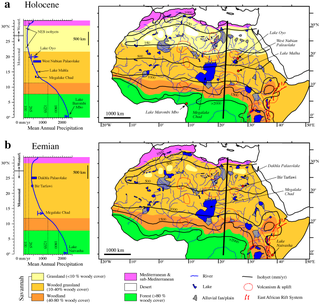
Lake Ptolemy is a former lake in Sudan. This lake formed during the Holocene in the Darfur region, during a time when the monsoon over Africa was stronger. The existence of the lake is dated between about 9,100–2,400 years before present. This lake could have reached a surface area of 30,750 square kilometres (11,870 sq mi), larger than present-day Lake Erie, although estimates of its size vary and it might have been much smaller. The shorelines in some places, insofar as they are recognizable, feature riparian landscapes and reeds. The lake was a freshwater lake replenished by groundwater and runoff from neighbouring mountains and might itself have been the source for the Nubian Sandstone Aquifer System. The lake featured a diverse ecosystem with a number of species, and possibly facilitated the spread of species between the Nile and Lake Chad.

The African humid period is a climate period in Africa during the late Pleistocene and Holocene geologic epochs, when northern Africa was wetter than today. The covering of much of the Sahara desert by grasses, trees and lakes was caused by changes in the Earth’s axial tilt; changes in vegetation and dust in the Sahara which strengthened the African monsoon; and increased greenhouse gases.

The Dongola Reach is a reach of approximately 160 km in length stretching from the Fourth downriver to the Third Cataracts of the Nile in Upper Nubia, Sudan. Named after the Sudanese town of Dongola which dominates this part of the river, the reach was the heart of ancient Nubia.

Cushitic-speaking peoples are the ethnolinguistic groups who speak Cushitic languages natively. Today, Cushitic languages are spoken primarily in the Horn of Africa, with minorities speaking Cushitic languages to the north and south in Egypt, the Sudan, Kenya, and Tanzania.

Darb El Arba'īn is the easternmost of the great north–south Trans-Saharan trade routes. The Darb El Arba'īn route was used to move trade goods, livestock and slaves via a chain of oases from the interior of Africa to portage on the Nile River and thence to the rest of the world.