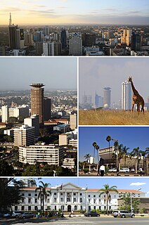
Nairobi is the capital and the largest city of Kenya. The name comes from the Maasai phrase Enkare Nairobi, which translates to "cool water", a reference to the Nairobi River which flows through the city. The city proper had a population of 4,397,073 in the 2019 census, while the metropolitan area has a population of 9,354,580. The city is popularly referred to as the Green City in the Sun.

Eldoret is a principal town in the Rift Valley region of Kenya and serves as the capital of Uasin Gishu County. The town is colloquially known as 'Sisibo'. As per the 2019 Kenya Population and Housing Census, Eldoret is the fifth most populated urban area in the country after Nairobi, Mombasa, Nakuru and Ruiru. Lying south of the Cherangani Hills, the local elevation varies from about 2100 meters at the airport to more than 2700 meters in nearby areas (7000–9000 feet). The population was 289,380 in the 2009 Census, and it is currently the fastest growing town in Kenya with 475,716 people according to 2019 National Census.

The Kamba or Akamba people are a Bantu ethnic group - or tribe - who predominantly live in the area of Kenya stretching from Nairobi to Tsavo and north to Embu, in the southern part of the former Eastern Province. This land is called Ukambani and constitutes Makueni County, Kitui County and Machakos County. They also form the second largest ethnic group in 8 counties including Nairobi and Mombasa counties.

Nakuru is the fourth-largest urban centre proper in Kenya after Nairobi, Mombasa, and Kisumu in that order. However, Nakuru's metro urban area is the third largest in Kenya after Nairobi and Mombasa. It is the capital of Nakuru County and former capital of the Rift Valley Province as well as home Flamingo Radio which is the largest neo-urban Radio in the metropolis. Its urban and rural population is 570,674 inhabitants according to the 2019 census. It is the largest urban centre in the Rift Valley with Eldoret in Uasin Gishu following closely behind. Nakuru lies about 1,850 m above sea level. Alternative names include Nax or Naxar, and Kurusalem.

Kitui is a town in Kenya, 180 kilometres east of Nairobi and 105 kilometres east of Machakos. it covers an area approximately 30,496.4 km squares and lies between latitudes 0°10 South and 3°0 South and longitudes 37°50 East and 39°0 East. It borders seven counties i.e Machakos and Makueni counties to the west, Tana River County to the east and south-east, Taita Taveta County to the south, Embu to the north-west, and Tharaka-Nithi and Meru counties to the north. Kitui became the headquarters of Kitui County after the adoption of the new constitution and the devolved government.

Embu County is a county of Kenya. The capital of Embu County and the former Eastern province headquarters, Embu is a large and largely metropolitan area with a population of 608,599 persons. The county borders Kirinyaga to the west, Kitui to the east, Tharaka Nithi to the north, Machakos to the south. The county occupies an area of 2,821 km2.

Machakos County is one of the 47 counties of Kenya. Its capital is Machakos. Its largest town is Machakos, the country's first administrative headquarters. The county had a population of 1,421,932 as of 2019. The county borders Nairobi and Kiambu counties to the west, Embu to the north, Kitui to the east, Makueni to the south, Kajiado to the south west, and Muranga and Kirinyaga to the north west.
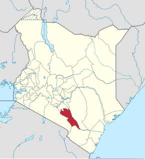
Makueni County is a county in the former Eastern Province of Kenya. Its capital and largest town is Wote. The county has a population of 987,653. The county lies between Latitude 1o 35 ́ and 32 00 ́ South and Longitude 37o10 ́ and 38o 30 ́ east. It borders Machakos to the North, Kitui to the East, Taita Taveta to the South and Kajiado to the West and covers an area of 8,008.9 km2.

Kitui County is a county in the former Eastern Province of Kenya. Its capital and largest town is Kitui, although Mwingi is also another major urban centre. The county has a population of 1,136,187. and an area of 30,430 km2. It lies between latitudes 0°10 South and 3°0 South and longitudes 37°50 East and 39°0 East.
Mwingi is a town in the Kitui County of Kenya. It has an urban population of 15,970. The town is located along the A3 Road between Nairobi and Garissa, 47 kilometres (29 mi) north of its county capital Kitui, and 200 kilometres (120 mi) east of the capital city of Nairobi. It was the capital of the former Mwingi District.

The districts of Kenya were divided into 262 divisions (matarafa). Divisions of Kenya were further subdivided into locations. Today's counties of Kenya are based on the merging of some of the districts on this list and since the divisions are one level under the districts they are now the sub-counties. This is because Kenya recently changed its constitution and 47 Counties emerged. Here are the divisions listed below, by district :
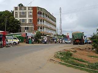
Kibwezi is a town in Makueni County, Kenya.
The Roman Catholic Diocese of Kitui is a Diocese located in the city of Kitui in the Ecclesiastical province of Nairobi in Kenya.
Ikanga is a village in Kitui District, Kenya, about 230 km (140 mi) east of Nairobi. It is 50 kilometres (31 mi) south of Kitui town along the B7 road between Kitui and Kibwezi. Ikanga forms a ward in the Kitui South Constituency and Kitui County Council. The total population of Ikanga and Kyatune was projected to be 36,185 in 2012.

The Chyulu Hills is a mountain range in Makueni County, South Eastern Kenya. It forms a 100 kilometre long volcanic field in elongated NW-SE direction. Its highest peak is 2188 metres high.
Ikutha is a semi-arid town located between Kitui and kibwezi. It is near Kibwezi town. You can find your way to Tsavo East from Ikutha town since there is a southern gate from ikutha town.
Sub-counties are the decentralised units through which county governments of Kenya will provide functions and services. Except for the parts which fall under urban areas, sub-counties will coincide with the constituencies created under article 89 of the Constitution of Kenya. Sub-counties will be headed by a sub-county administrator, appointed by a County Public Service Board.
Mutomo District was a former district in the Eastern Province of Kenya. Its population is 180,000. The administrative center of the district is Mutomo. In 2010, it was merged into Kitui County.
South Eastern Kenya University "SEKU" is a public university with its main campus located in Kwa Vonza, Kitui County, Kenya.
The Kibwezi–Kitui–Kandwia–Usueni Road, also B7 Road (Kenya) is a road in Kenya, the largest economy in the East African Community. The road connects the town of Kibwezi in Makueni County to the community of Usueni in Kitui County. Since its upgrading, the road has opened up many villages and rural-urban settings to business and agricultural activities.
