Related Research Articles

Busia is a county in the former Western Province of Kenya. It borders Kakamega County to the east, Bungoma County to the north, Lake Victoria and Siaya County to the south and Busia District, Uganda to the west. The county has about 893,000 people and spans about 1,700 square kilometers making it one of the smallest counties in Kenya. Busia is inhabited by the Luhya tribe of Kenya and the Teso of Kenya, and small groups of the Luo. The Luhya communities include the Abakhayo, Marachi, Samia and Abanyala communities.
Laikipia County is one of the 47 Counties of Kenya, located on the Equator in the former Rift Valley Province of the Country. Laikipia is a cosmopolitan County and is Listed as County number 31. The county has two major urban centres: Nanyuki to the southeast, and Nyahururu to the southwest. Its County government headquarters town is Nanyuki. The County lies between latitudes 0° 18" South and 0° 51" North and between longitude 36° 11" and 37° 24' East. It borders Samburu County to the North, Isiolo County to the North East, Meru County to the East, Nyeri County to the South East, Nyandarua County to the South, Nakuru County to the South West and Baringo County to the West.

Lamu County is a county of Kenya located along the North Coast of the country and is one of the six Coastal Counties in Kenya. Its capital is the town of Lamu. It borders Tana River County to the southwest, Garissa County to the north, Somalia to the northeast, and the Indian Ocean to the South.

Mombasa County is one of the 47 counties of Kenya. Its capital is Mombasa. In terms of economy it is second after Nairobi. Initially it was one of the former districts of Kenya but in 2013 it was reconstituted as a county, on the same boundaries. It is the smallest county in Kenya, covering an area of 229.7 km2 excluding 65 km2 of water mass. The county is situated in the south eastern part of the former Coast Province. It borders Kilifi County to the north, Kwale County to the south west and the Indian Ocean to the east. Administratively, the county is divided into seven divisions, eighteen locations and thirty sub-locations.
Kapenguria is a town in Kenya. It is the capital and largest urban center of West Pokot County. The town lies north east of Kitale on the A1 road in Kenya. Kapenguria forms a municipality with a population of 40,751 as per the 2019 Kenya Population and Housing Census.
Wajir is the capital of Wajir County of Kenya. It is situated in the former North Eastern Province.

Kiambu County is a county in the former Central Province of Kenya. Its capital is Kiambu and its largest town is Thika. Kiambu County is the second most populous after Nairobi County. Kiambu County borders Nairobi and Kajiado Counties to the South, Machakos to the East, Murang'a to the North and North East, Nyandarua to the North West, and Nakuru to the West and has a population of 2,417,735.
Kilifi County was formed in 2010 as a result of a merger of Kilifi District and Malindi District, Kenya. Its capital is Kilifi and its largest town is Malindi. Kilifi county is one of the five counties that make up the Kenyan Coast. The county has a population of 1,453,787 people following the 2019 census which covers an area of 12,245.90 km2 (4,728.17 sq mi).

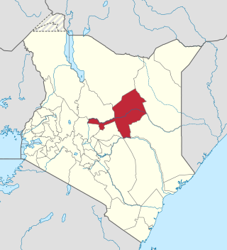
Marsabit County is a county in Kenya. Covering a surface area of 66,923.1 square kilometres. Marsabit is the second largest county in Kenya. Its capital is Marsabit and its largest town Moyale. According to the 2019 census, the county has a population of 459,785. It is bordered to the North by Ethiopia, to the West by Turkana County to the South by Samburu County and Isiolo County, and to the East by Wajir County.

Taita–Taveta County previously known as Taita Taveta District is a county of Kenya. It lies approximately 200 km northwest of Mombasa and 360 km southeast of Nairobi.Taita-Taveta County is located approximately 360 km southeast of Nairobi and 200 km northwest of Mombasa and is a port and major gateway to the United Republic of Tanzania through Taveta town. The County headquarters are located in Mwatate sub-county, which is one of the six counties in the Jumuiya ya Kaunti za Pwani regional economic bloc. Major towns include Voi, Taveta, Mwatate and Wundanyi
Isiolo County is a county in the former Eastern Province of Kenya. Its population is 268,002 and its capital and largest city is Isiolo. Isiolo County is to be the first county to be developed as part of the Kenya Vision 2030 program. Other upcoming urban centres are: Garbatulla, Modogashe, Kinna, Merti and Oldonyiro.

Kajiado County is a county in the former Rift Valley Province of Kenya. As of 2019, Kajiado county spanned an area of 21,292.7 km2, with a recorded population of 1,117,840. The county borders Nairobi and to its south it borders the Tanzanian regions of Arusha and Kilimanjaro. The county capital is Kajiado, but the largest town is Ongata Rongai. Its main tourist attraction is its wildlife.

Baringo County is one of the 47 counties in Kenya. It is located in the former Rift Valley Province. Its headquarters and largest town is Kabarnet. The county is home to Lake Baringo, Lake Bogoria and Lake Kamnarok.

Garissa County is an administrative county in Kenya. Its capital and largest urban area is Garissa. The county had a population of 841,353 at the 2019 Census, and a land area of about 44,753 km2 (17,279 sq mi).

Mandera County is the northeasternmost county in Kenya. Its capital and largest town is Mandera. The county is bordered by Ethiopia to the north, Somalia to the east and Wajir County to the southwest. According to the 2019 census, the county has a population of 1,200,890 and an area of 25,939.8 square kilometres (10,015.4 sq mi). The main economic activity in the county is pastoralism, while others include cross-border trade with Ethiopia, artisanal mining, beekeeping, and agriculture along the Dawa River.
Bomet County is a county in the former Rift Valley Province of Kenya. Initially a district, Bomet District was created from the former Kericho District in 1992. The capital of Bomet County is Bomet. It has a population of 875,689 in 2019 and an area of 1,630.0 km2 (629.3 sq mi).
Mariakani is a town in Kenya lying on the boundary of Kaloleni and Kinango districts in the old Coast Province of Kenya, 36 kilometres northwest of the port city of Mombasa.
Kisauni Constituency is an electoral constituency in Kenya. It is one of six constituencies in Mombasa County. The constituency has seven wards electing councillors for the Mombasa municipal council. With the promulgation of the new constitution in August 2010, Nyali Constituency was carved out from Kisauni Constituency.
Ganze Constituency is an electoral constituency in Kenya. It is one of seven constituencies in Kilifi County. The constituency has four wards, all electing Members of County Assembly for the Kilifi County Assembly. The constituency was established for the 1988 elections. After the IEBC adopted the Boundary commission's recommendation for new constituencies and boundaries, Ganze Constituency retained its name, and no major boundaries were altered. It has a population of 143,906 according to the 2019 census report by the Kenya National bureau of Statistics (KNBS). Its current member of parliament is Hon. Charo Kenneth Kazungu Tungule of Pamoja African alliance Party (PAA).

Kisii County is a county in the former Nyanza Province in southwestern Kenya. Its capital and largest town is Kisii. The county has a population of 1,266,860 people. It borders Nyamira County to the North East, Narok County to the South, and Homa bay and Migori Counties to the West. The county covers an area of 1,318 km².
References
- ↑ Center for Multiparty Democracy: Politics and Parliamentarians in Kenya 1944–2007 Archived 2008-02-28 at the Wayback Machine
- ↑ Kenya National Bureau of Statistics, KNBS (2019). 2019 KENYA POPULATION AND HOUSING CENSUS. Nairobi, Kenya: Kenya National Bureau of Statistics. p. 12. ISBN 978-9966-102-09-6.
- ↑ information.go.ke: CDF allocation by sector and location (2003-6) [ permanent dead link ]
| | This Kenya related article is a stub. You can help Wikipedia by expanding it. |
| | This African election-related article is a stub. You can help Wikipedia by expanding it. |