Related Research Articles

Busia is a county in the former Western Province of Kenya. It is located directly east of the border town of Busia, Uganda, and borders Lake Victoria to the southwest, Siaya County to the southeast, and Bungoma County and Kakamega County to the east. The county is composed of six sub-counties, and had a population of 893,681 as of the most recent census in 2019.

Kericho County is one of the 47 counties in Kenya. The county seats between longitude 35°02' and 35°40' East and between the equator and latitude 0°23' South with an altitude of about 2002m above sea level. It borders Uasin Gishu County to the North, Baringo County to the North-East, Nandi County to the North-West, Nakuru County to the East and Bomet County to the South, Kisumu County to the Northwest and Nyamira County to the West. It had a population of 901,777 and an area of 2,111 km². Its capital and largest town is Kericho.

Lamu County is a county in Kenya located along the North Coast of the country and is one of the six Coastal Counties in Kenya. Its capital is the town of Lamu. It borders Tana River County to the southwest, Garissa County to the north, Somalia to the northeast, and the Indian Ocean to the South. It is the Smallest County in Kenya by population.

Kiambu County is a county in the former Central Province of Kenya. Its capital is Kiambu and its largest town is Thika town. Kiambu County is the second most populous county in Kenya after Nairobi County. Kiambu County borders Nairobi and Kajiado Counties to the South, Machakos to the East, Murang'a to the North and North East, Nyandarua to the North West, and Nakuru to the West. It has a population of 2,417,735.
Kilifi County was formed in 2010 as a result of a merger of Kilifi District and Malindi District, Kenya. Its capital is Kilifi and its largest town is Malindi. Kilifi county is one of the five counties that make up the Kenyan Coast. The county had a population of 1,453,787 people following the 2019 census and covers an area of 12,245.90 km2 (4,728.17 sq mi).

Marsabit County is a county in Kenya, covering a surface area of 66,923.1 square kilometres. Marsabit is the second largest county by size in Kenya after Turkana county which has an area of 71,597.8 km2. Its capital is Marsabit and its largest town is Moyale. According to the 2019 census, the county had a population of 459,785. It is bordered to the North by Ethiopia, to the West by Turkana County to the South by Samburu County and Isiolo County, and to the East by Wajir County.
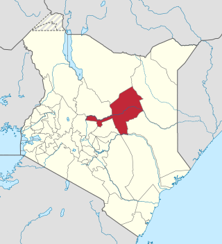
Isiolo County is a county in the former Eastern Province of Kenya. Its population was 268,002 according to 2019 census. The capital and largest town in the county is Isiolo. Isiolo County is set to be the first county to be developed as part of the Kenya Vision 2030 program. Other upcoming urban centres are: Garbatulla, Modogashe, Kinna, Merti and Oldonyiro. The county is home to Sakuye and Borana tribes and a significant number of people from Turkana, Samburu, Gabra, Garre and Meru communities.

Makueni County is a county in the former Eastern Province of Kenya. Its capital town is Wote. It's the largest town in the county. Emali town which is an important market and stop over for the Standard Gauge Railway (SGR), is another major town in the county. It is multicultural and adds diversity to Makueni County. The county had a population of 987,653 in the 2019 census. The county lies between Latitude 1° 35' and 2° 59' South and Longitude 37° 10' and 38° 30' East. It borders Machakos County to the North, Kitui County to the East, Taita Taveta County to the South and Kajiado County to the West and covers an area of 8,008.9 km2.

Kitui County is one of the 47 counties of Kenya in the former Eastern Province of Kenya. Its capital and largest town is Kitui. Mwingi is also another major urban centre. The county has a population of about 1.2 million people and an area of 30,496 km2. It lies between latitudes 0°10 South and 3°0 South and longitudes 37°50 East and 39°0 East.

Garissa County is a county in Kenya located in Eastern Kenya bordering Somalia to the East, Wajir County and Isiolo County to the North, Tana River County to the West, Lamu County to the South and the Indian ocean. Its capital and largest urban area is Garissa.

Mandera County is a county in northeastern Kenya, bordering Ethiopia to the north, Somali to the east, and Wajir to the south. It is predominantly home to the Somali community, with a population of about 983,000 (2024), making it the 28th largest county in Kenya by population. Covering an area of approximately 25,797 square kilometers, Mandera County features natural landscapes, including the Dawa River and vast deserts.

Bomet County is located in the Rift Valley region of Kenya, was established in 2010 and had a population of approximately 875,689[¹], making it the 32nd largest county in Kenya by population. It is bordered by Kericho County to the west, Nakuru County to the northwest, and Narok County to the southeast. The county is characterized by its rolling hills, fertile agricultural land, and significant natural resources, including the Mau Forest and rivers such as Nyangores and Chepalungu. The predominant ethnic group is the Kalenjin, known for their rich cultural heritage and agricultural practices.
Changamwe Constituency is an electoral constituency in Mombasa County, Kenya. It used to be one of the four constituencies in Mombasa district. With the promulgation of the new constitution in August 2010, it saw the creation of two more constituencies in Mombasa County. These were Jomvu and Nyali Constituencies which were curved out from Changamwe and Kisauni Constituencies, respectively. This made a total of six constituencies in 2012.
Kisauni Constituency is an electoral constituency in Kenya and is located in Mombasa County.
Rongai Constituency is an electoral constituency in Kenya. It is one of eleven constituencies in Nakuru County. The constituency has eight wards, all electing Members of County Assembly (MCAs)for the Nakuru County Assembly. The constituency was established for the 1988 elections when it was carved out of Nakuru North Constituency.
Limuru Constituency is an electoral constituency in Kenya. It is one of twelve constituencies in Kiambu County. The constituency was established for the 1963 elections and since then, the constituency's population has grown to 159,314 people according to the 2019 census.
Nyakach is an electoral constituency in Kenya. It is one of seven constituencies of Kisumu County. The constituency has five wards, all electing MCAs for the Kisumu County Assembly and has a population of 150,320 people based on the 2019 census report.

Nairobi City County is one of the 47 counties of Kenya. With an estimated population of 5,454,000 in 2024, it is the third-smallest in area of the counties, yet the most populous. It also serves as the capital of Kenya. The county entity was effected in 2013, replacing Nairobi City Council, which had been the long-standing unit of local administration since before Kenya's independence. The city county consists of eleven gazetted sub-counties and eighty-five electoral wards. On the national level, Nairobi also sends seventeen Members of Parliament across the constituencies, one County Woman Representative to the National Assembly; and one senator to the Senate. The county government, which is allotted devolved functions as stated in the Constitution of Kenya, is headed by a county governor, who appoints his/her cabinet. The county's legislature is headed by the County Speaker, who presides over the County Assembly. The Members of the County Assembly (MCAs) are elected from single-member districts and represent their respective electoral wards. Additional MCAs are also nominated by political parties as a form of affirmative action.

The Counties of Kenya are geographical units created by the 2010 Constitution of Kenya as the new units of devolved government. They replaced the previous provincial system. The establishment and executive powers of the counties is provided in Chapter Eleven of the Constitution on devolved government, the Constitution's Fourth Schedule and any other legislation passed by the Senate of Kenya concerning counties. The counties are also single-member constituencies which elect members of the Senate, and special woman members to the National Assembly.
Kilifi North Constituency is an electoral constituency in Kenya. It is one of seven constituencies in Kilifi County. It was part of the former Bahari Constituency which was split into two by the IEBC Act.` It is also the administrative headquarters for Kilifi county and home to the only university in the county, Pwani University. It has a population of 178,824 people according to the 2019 census report.
References
- ↑ Kenya National Bureau of Statistics, KNBS (2019). 2019 KENYA POPULATION AND HOUSING CENSUS. Nairobi Kenya: Kenya National Bureau of Statistics. p. 12. ISBN 978-9966-102-09-6.
- ↑ "Speaker – Kilifi County Assembly" . Retrieved 2024-09-04.
- ↑ Center for Multiparty Democracy: Politics and Parliamentarians in Kenya 1944–2007 Archived October 28, 2008, at the Wayback Machine
- ↑ information.go.ke: CDF allocation by sector and location (2003-6) [ permanent dead link ]
- ↑ http://kenyaelectiondatabase.co.ke/?page_id=1010 [ dead link ]