Laikipia County is one of the 47 Counties of Kenya, located on the Equator in the former Rift Valley Province of the Country. Laikipia is a cosmopolitan County and is Listed as County number 31. The county has two major urban centres: Nanyuki to the southeast, and Nyahururu to the southwest. Its County government headquarters town is Rumuruti. The County lies between latitudes 0° 18" South and 0° 51" North and between longitudes 36° 11" and 37° 24' East. It borders Samburu County to the North, Isiolo County to the North East, Meru County to the East, Nyeri County to the South East, Nyandarua County to the South, Nakuru County to the South West and Baringo County to the West.
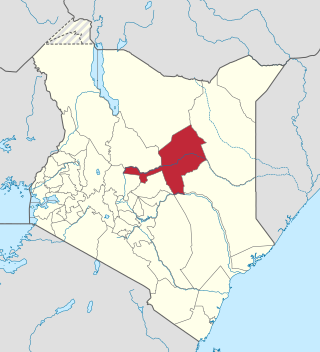
Marsabit County is a county in Kenya, covering a surface area of 66,923.1 square kilometres. Marsabit is the second largest county by size in Kenya after Turkana county which has an area of 71,597.8 km2. Its capital is Marsabit and its largest town is Moyale. According to the 2019 census, the county has a population of 459,785. It is bordered to the North by Ethiopia, to the West by Turkana County to the South by Samburu County and Isiolo County, and to the East by Wajir County.
Isiolo County is a county in the former Eastern Province of Kenya. Its population is 268,002 and its capital and largest city is Isiolo. Isiolo County is to be the first county to be developed as part of the Kenya Vision 2030 program. Other upcoming urban centres are: Garbatulla, Modogashe, Kinna, Merti and Oldonyiro. The county is home to Sakuye and Borana tribes but also has a significant number of people from Turkana, Samburu, Gabra, Garre and Meru communities.

Garissa County is an administrative county in Kenya. It is located in Eastern Kenya bordering Somalia to the East, Wajir County and Isiolo County to the North, Tana River County to the West and Lamu County to the South. Its capital and largest urban area is Garissa.
Lang'ata Constituency is an electoral constituency in Nairobi City County. It is one of the seventeen constituencies in the county, consisting of southern and southwestern areas of Nairobi. Langata constituency had common boundaries with a now-defunct Kibera Division of Nairobi. It is the largest constituency in Nairobi with an area of 196.80 km2 (76.0 sq mi). It was known as Nairobi South Constituency at the 1963 elections but since the 1969 elections it has been known as Lang'ata Constituency.

North Horr Constituency is an electoral constituency in Kenya. It is one of four constituencies in Marsabit County. The entire constituency is located within Marsabit County Council area. The constituency was established for the 1988 elections. It is the largest constituency in Kenya on land coverage and hosts the only true desert in Kenya, Chalbi desert. Kenya's well known politician Godana Bonaya was its first member of parliament, and he represented the constituency until his demise in a Kenya Air Force Y-12 plane crash on 10 April 2006 in which all the legislators from Marsabit county perished.
Kitutu Masaba is an electoral constituency in Kenya. It was known as Kitutu East Constituency from 1963 to 1988. It is one of four constituencies of Nyamira County. The constituency renamed to Kitutu Masaba prior to the 1988 elections.
Cherangany Constituency, comprises the larger Trans Nzoia East District; otherwise known as Cherangani Sub-County, with an approximate area of 556.9 square km. It is an electoral constituency in Kenya, which was established/created for the 1988 general election.
Kikuyu Constituency is an electoral constituency in Kenya. It is one of twelve constituencies in Kiambu Countyand was established during the 1963 elections. From the period 1988 elections were held until the 2002 elections were held in Kenya, it was known as Kabete Constituency. With the new demarcation of constituencies by the Independent Electoral and Boundaries Commission (IEBC), the constituency was split into two and now we have Kikuyu Constituency and Kabete Constituency.
Changamwe Constituency is an electoral constituency in Mombasa County, Kenya. It used to be one of the four constituencies in Mombasa district. With the promulgation of the new constitution in August 2010, it saw the creation of two more constituencies in Mombasa County. These are Jomvu and Nyali Constituencies which were curved out from Changamwe and Kisauni Constituencies respectively thereby bringing a total of six constituencies in 2012.
Ganze Constituency is an electoral constituency in Kenya. It is one of seven constituencies in Kilifi County. The constituency has four wards, all electing Members of County Assembly for the Kilifi County Assembly. The constituency was established for the 1988 elections. After the IEBC adopted the Boundary commission's recommendation for new constituencies and boundaries, Ganze Constituency retained its name, and no major boundaries were altered. It has a population of 143,906 according to the 2019 census report by the Kenya National bureau of Statistics (KNBS). Its current member of parliament is Hon. Charo Kenneth Kazungu Tungule of Pamoja African alliance Party (PAA).
Butula Constituency is an electoral constituency in Kenya. It is one of seven constituencies in Busia County. The constituency was established for the 1997 elections. The constituency has six wards, all electing members of county assembly(MCA) for the Busia County government. The current member of parliament is Joseph Maero Oyula.

Laisamis Constituency is an electoral constituency in Kenya. It is one of four constituencies in Marsabit County. The entire constituency is located within Marsabit County Council area. The constituency was established for the 1988 elections. Formally known as Marsabit South, it was represented by Hon. Phillip Kurungu in the 1966 elections. From 1969-1988 Laisamis Constituency was represented by Hon. Haji Kholkhale Adichareh. Hon. Adichareh was a Lancaster House Conference delegate and was a fierce defender of Rendille land. He served 7 years at Shimo La Tewa prison on trumped up charges and emerge to lead his Rendille community for 20 years in parliament.
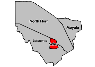
Marsabit central (Saku Constituency) is an electoral constituency in Kenya. It is one of four constituencies in Marsabit County in Northern Kenya. It borders North Horr Constituency to the North and Laisamis Constituency to the South. The constituency was established for the 1988 elections. Marsabit town which is the county headquarters is in Saku constituency.
Mogotio Constituency is an electoral constituency in Baringo County, Kenya. It is one of six constituencies in the county and was one of two constituencies of the former Koibatek District. It was established before the 1997 elections. There are 12 wards, all electing councillors for the Koibatek County Council. It is home to notable politicians like Hon. Jacob Kiprotich Cheboiwo, who is the current Member of county assembly for Kisanana.
North Mugirango is one of four constituencies in Nyamira County. In 1966 the North Mugirango Constituency was split into West Mugirango and a smaller North Mugirango. The name was changed to Borabu / North Mugirango Constituency in 1974. In 1987 the name changed back to North Mugirango. Prior to 2013, it was formally known as North Mugirango (Borabu) Constituency.

Isiolo South Constituency is an electoral constituency in Kenya. It is one of two constituencies of Isiolo County. The constituency has nine wards, all electing councillors to the Isiolo County Council. The constituency was established for the 1966 elections.

Moyale Constituency is an electoral constituency in Kenya. It is one of four constituencies in Marsabit County, and it was the only constituency in the former Moyale District. The constituency has nine wards, all electing councillors to the Moyale County Council. The constituency was established for the 1966 elections.
West Mugirango Constituency is an electoral constituency in Kenya. It is one of four constituencies of Nyamira County. The constituency was established for the 1966 elections from what was a larger North Mugirango Constituency.
Local elections were held in Isiolo County to elect a Governor and County Assembly on 4 March 2013. Under the new constitution, which was passed in a 2010 referendum, the 2013 general elections were the first in which Governors and members of the County Assemblies for the newly created counties were elected. They will also be the first general elections run by the Independent Electoral and Boundaries Commission(IEBC) which has released the official list of candidates.
