Related Research Articles

Hola, also known as Galole, is a small town in Kenya on the Tana River with a population of 6,932. Hola is the capital of the Tana River County. It is a busy market town and a portal to Garissa County and the former North Eastern Province by local canoe ferry across the Tana River.

Lamu County is a county of Kenya located along the North Coast of the country and is one of the six Coastal Counties in Kenya. Its capital is the town of Lamu. It borders Tana River County to the southwest, Garissa County to the north, Somalia to the northeast, and the Indian Ocean to the South.

Tana River County is a county in the former Coast Province of Kenya. It is named after the Tana River, the longest river in Kenya. It has an area of 38,437 km2 (14,841 sq mi) and a population of 315,943 as of the 2019 census. The county borders Kitui County to the west, Garissa County to the northeast, Isiolo County to the north, Lamu County to the southeast and Kilifi County to the south.The administrative headquarter of the county is Hola also known as Galole. The County has five (5) sub Counties; Tana Delta, Tana River, Tana North, Galedyertu and Bangal.

Athi River is a town outside Nairobi, Kenya in Machakos County. The town is named after the Athi River, which passes through. It is also known as Mavoko.
Mûkûrwe'inî was a former district in Nyeri County, Kenya.
Isiolo County is a county in the former Eastern Province of Kenya. Its population is 268,002 and its capital and largest city is Isiolo. Isiolo County is to be the first county to be developed as part of the Kenya Vision 2030 program. Other upcoming urban centres are: Garbatulla, Modogashe, Kinna, Merti and Oldonyiro.

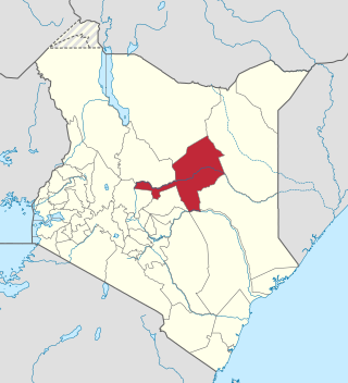
Garissa County is an administrative county in Kenya. It is located in Eastern Kenya bordering Somalia to the East, Wajir County and Isiolo County to the North, Tana River County to the West and Lamu County to the South. Its capital and largest urban area is Garissa.
Tetu Constituency is an electoral constituency in Kenya. It was established in 1988 and is one of the six constituencies in Nyeri County.
Gatundu South is an electoral constituency in Kiambu County, Kenya and the seat of the District Officer in Gatundu Town. It is one of twelve constituencies in Kiambu County. The constituency has four wards, Kiamwangi, Kiganjo, Ndarugo and Ng'enda all of them are within Kiambu County council. The constituency was established before the 1997 General Elections. Previously it was part of the larger Gatundu Constituency which was split into Gatundu South Constituency and Gatundu North Constituency it is ranked 182 out of 210 Constituencies in Kenya in size and 165 out of 210 in population size.
Bondo Constituency is an electoral constituency in Kenya. It is one of six constituencies in Siaya County. Lake Victoria border it on the west and south west, Rarieda Constituency border it on the South West to the Eastern side and River Yala on the North. Its major and biggest town is Bondo town. Usenge, Nyamonye, Nyang'oma and K'Oppolo are other town centers.
Kitutu Masaba is an electoral constituency in Kenya. It is one of four constituencies of Nyamira County. The constituency was established for the 1988 elections.
Changamwe Constituency is an electoral constituency in Mombasa county, Kenya. It used to be one of the four constituencies in Mombasa district. With the promulgation of the new constitution in August 2010, it saw a creation of two more constituencies in Mombasa County. These are Jomvu and Nyali Constituencies which were curved out from Changamwe and Kisauni Constituencies respectively thereby bringing a total of six constituencies in 2012.

Mukurweini Constituency is an electoral constituency in Kenya. It is one of six constituencies in Nyeri County. Mukurweini Constituency comprises Mukurweini division of Nyeri County. The constituency has seven wards, all electing councillors for the Nyeri County Council. The constituency was established for the 1969 elections.
Kacheliba Constituency is an electoral constituency in Kenya. It is one of the four constituencies of West Pokot County. The constituency has six wards, which are represented by Members of County Assembly at the West Pokot County Assembly in Kapenguria. The constituency was established before the 1988 elections in order to cater for the interests of the Kara-Pokot community following years of under representation. The constituency was created by the Electoral Commission of Kenya through a publication in the Kenya Gazette.
West Mugirango Constituency is an electoral constituency in Kenya. It is one of four constituencies of Nyamira County. The constituency was established for the 1966 elections from what was a larger North Mugirango Constituency.
Bura Constituency is an electoral constituency in Kenya. It is one of three constituencies in Tana River County. The constituency has nine wards, all electing councillors to the Tana River County Council. The constituency was established for the 1997 elections.
Garsen Constituency is an electoral constituency in Kenya. It is one of three constituencies in Tana River County. The constituency has nine wards, all electing councillors to the Tana River County Council. The constituency was established for the 1988 elections.
Mathioya Constituency is an electoral constituency in Kenya. It is one of seven constituencies of Muranga County. The constituency has three wards comprising Kiru, Kamacharia and Gitugi wards all electing Members of the County Assembly to the Muranga County Assembly.
Masalani is a town in Garissa County, Kenya. It was the headquarters of the former Ijara District. It is on the eastern shores of Tana River, 30 kilometres south of Hola and 60 kilometres north of Garsen

Sub-counties, formerly known as Districts, are the decentralised units through which government of Kenya provides functions and services. At national level, sub-counties take a more administrative function like security, statistical purposes, provision of government services, etc. Even though the sub-counties are divisions of counties, powers to create new national sub-counties lies with the national government. As of 2023, there are 314 sub-counties, compared to 290 constituencies. A deputy county commissioner is appointed by the state to lead each sub-county. The sub-counties are further divided into divisions, locations and sub-locations.
References
- ↑ Center for Multiparty Democracy: Politics and Paliamenterians in Kenya 1944-2007
- ↑ Electoral Commission of Kenya: Registered voters per polling station by electoral area/ward and constituency Archived September 29, 2007, at the Wayback Machine