Related Research Articles

Murang'a County is one of the counties of Kenya's former Central Province. Its largest town and capital is Murang'a, which was referred to as Fort Hall during the colonial era. The county is inhabited mainly by and is considered the birthplace of the Gikuyu, the largest ethnic group in Kenya. The county has a population of 1,056,640 based on the 2019 census.
Mûkûrwe'inî was a former district in Nyeri County, Kenya.

Local authorities in Kenya are the bodies controlling local governance in urban areas in Kenya.
Kerugoya is the biggest town in Kirinyaga County, located 10 kilometres east of Karatina and 40 kilometres west of Embu. It is situated in the former Kirinyaga district. Travel directions by road from Nairobi is through Thika Road past Thika, Kenol and Makuyu. The road leads through Makutano until Sagana town, where a road branches off the East towards Kagio town up to Kirinyaga University branching North towards the town.
Kandara is a town in Muranga County, Kenya. Kandara is located 10 kilometres south of Kigumo and 30 kilometres north of Thika. Kandara hosts a town council with a population of 28,840.
Mwingi North Constituency is an electoral constituency in Kenya. It is one of eight constituencies in Kitui County. It used to be one of two constituencies in Mwingi District. The constituency was established for the 1997 elections.

Kiharu Constituency is an electoral constituency in Kenya. It is one of seven constituencies of Muranga County. The Murang'a town is located within this constituency. Between 1966-1983 the constituency was known as Mbiri Constituency.
Kajiado North Constituency is an electoral constituency in Kenya. It is one of five constituencies in Kajiado County. The constituency was established for the 1966 elections. The entire area of the constituency is located in Kajiado County.

North Horr Constituency is an electoral constituency in Kenya. It is one of four constituencies in Marsabit County. The entire constituency is located within Marsabit County Council area. The constituency was established for the 1988 elections. It is the largest constituency in Kenya on land coverage and hosts the only true desert in Kenya, Chalbi desert. Kenya's well known politician Godana Bonaya was its first member of parliament, and he represented the constituency until his demise in a Kenya Air Force Y-12 plane crash on 10 April 2006 in which all the legislators from Marsabit county perished.
Keiyo South is an electoral constituency in Kenya. It is one of four constituencies of Elgeyo-Marakwet County. The constituency has 6 wards, all of which elect Member of County Assembly (MCA) for Elgeyo Marakwet County which sits in the county Headquarters, Iten. The wards are namely: Metkei, Kabiemit, Chepkorio, Soy South and Soy North. The constituency was established for the 1969 elections. It was previously one of two constituencies of the former Keiyo District.
Kuresoi Constituency is a former electoral constituency in Kenya. The constituency was established for the 1997 elections. In 2010, it was split into Kuresoi North Constituency and Kuresoi South Constituency
Mathira Constituency is an electoral constituency in Kenya. It is one of six constituencies in Nyeri County. The constituency was established for the 1963 elections. Mathira is popularly known as Mathira ya Githomo (education) as it has an educated population in the country. It sits at the foot of Mount Kenya, and this gives it a climate that is suitable for growing tea and coffee. Karatina is to the east. Several tarmac roads crisscross Mathira, including the Kenol-Marua superhighway.
Kasipul Kabondo Constituency was an electoral constituency in Kenya. It was one of two constituencies in Rachuonyo District. With the new constitution of 2010, the constituency was divided into Kasipul Constituency and Kabondo Constituency, both in Homa Bay County.
Bahari Constituency was an electoral constituency in Kenya. It was one of three constituencies in Kilifi District, which is now Kilifi County and was established for the 1988 elections. In 2013, Bahari Constituency was dissolved and replaced by Kilifi South Constituency and Kilifi North Constituency.
Kigumo Constituency is an electoral constituency in Kenya. It is one of the seven districts of Muranga County. It was previously one of three constituencies in the former Maragua District, Central Province. The constituency was established for the 1963 elections.
Mbeere North Constituency is an electoral constituency in Embu County, Kenya. It was formerly known as Siakago Constituency, one of two constituencies of the former Mbeere District. It has five wards, all of which elected councillors for the Mbeere County Council.

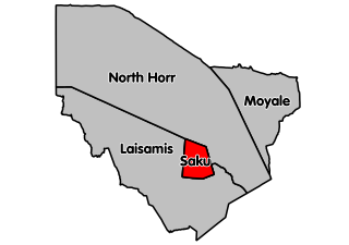
Marsabit central (Saku Constituency) is an electoral constituency in Kenya. It is one of four constituencies in Marsabit County in Northern Kenya. It borders North Horr Constituency to the North and Laisamis Constituency to the South. The constituency was established for the 1988 elections. Marsabit town which is the county headquarters is in Saku constituency.
Mathioya Constituency is an electoral constituency in Kenya. It is one of seven constituencies of Muranga County. The constituency has three wards comprising Kiru, Kamacharia and Gitugi wards all electing Members of the County Assembly to the Muranga County Assembly.
Igembe South Constituency is an electoral constituency in Kenya. It is one of nine constituencies of Meru County. The constituency was established for the 1988 elections. It was known as Igembe Constituency before the 2007 elections.
Igembe North Constituency is an electoral constituency in Kenya. It is one of nine constituencies of Meru County. The constituency has seven wards, all of which elect councillors for the Nyambene County Council. The constituency was established for the 1988 elections. It was known as Ntonyiri Constituency before the 2007 elections.
References
- ↑ Center for Multiparty Democracy: Politics and Parliamentarians in Kenya 1944–2007 Archived 28 October 2008 at the Wayback Machine
- ↑ information.go.ke: CDF allocation by sector and location (2003–6) [ permanent dead link ]
- ↑ Electoral Commission of Kenya: Registered voters per polling station by electoral area/ward and constituency Archived 29 September 2007 at the Wayback Machine