Related Research Articles
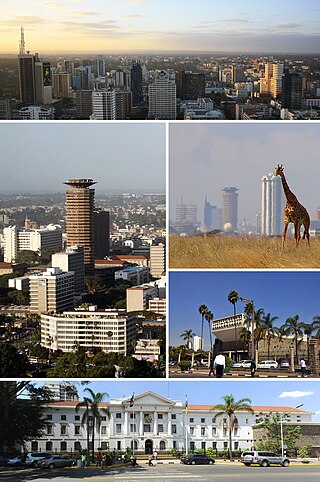
Nairobi is the capital and largest city of Kenya. The name is derived from the Maasai phrase Enkare Nairobi, which translates to 'place of cool waters', a reference to the Nairobi River which flows through the city. The city proper had a population of 4,397,073 in the 2019 census. The city is commonly referred to as The Green City in the Sun.
Kariobangi is a low-income residential estate in northeastern Nairobi. It consists of both apartments and slum-type dwellings. The name Kariobangi is believed to have come from an English phrase "Carry your bags" that was used by a white settler during the colonial period, that African natives mispronounced. It is split into two parts, Kariobangi North and Kariobangi South. The northern part was constructed first, with first buildings built in 1961. Kariobangi North is part of the Embakasi North electoral constituency. Kariobangi South is in the Embakasi West constituency. Kariobangi falls under two Nairobi sub-counties: with the north in Kasarani and the south in Njiru.
Dandora is an Estate in Kenya's capital and largest city, Nairobi. It is part of the Embakasi division. Surrounding neighbourhoods include slums such as Kariobangi, Baba Dogo, Gitare Marigo and Korogocho. Dandora was established in 1977, with partial financing by the World Bank in order to offer a higher standard of housing.

Embakasi is a neighbourhood in the city of Nairobi. It is approximately 18 kilometres (11 mi), southeast of the central business district. Embakasi is considered part of Nairobi's Eastlands area, lying to the south-east of Nairobi County. The Embakasi proper covers other estates in Eastlands such as Donholm, Pipeline, Tena, and Makadara estates. It borders South C and contains South B and slightly more than one third of Nairobi's Industrial Area and Export Processing Zones.
Embakasi Constituency,, is a former electoral constituency in Kenya. It was one of eight constituencies of Nairobi Province. It consisted of eastern and southeastern suburbs of Nairobi. With 164,227 registered voters, it was the most populous constituency in Kenya. It covered most of the Eastlands part of Nairobi. Embakasi constituency had common boundaries with Embakasi Division. The entire constituency was located within Nairobi City Council area. The constituency had an area of 208 km2.
Kasarani Constituency is an electoral constituency in Nairobi. It is one of seventeen constituencies of Nairobi City County. The entire constituency is located within Nairobi City County. It has an area of 152.60 km2 (58.9 sq mi), making it the second-largest constituency in Nairobi after Lang'ata. It borders Ruaraka, Embakasi Central, Embakasi North, Embakasi East, Roysambu constituencies to the west; Ruiru constituency to the north; Matungulu constituency to the east and Mavoko constituency to the south-east.
Kahawa is a mixed-use settlement spanning the Kiambu and Nairobi county borders along Thika Road. It is electorally divided into four wards across the two counties: Kahawa and Kahawa West wards in Nairobi county and Kahawa Wendani and Kahawa Sukari wards in Kiambu county. Despite its proximity to the city, half of it is administratively in Ruiru, while some parts, such as Kenyatta University, Kahawa Barracks, Kiwanja and Githurai 44, are administratively in Kasarani.

Githurai is a composition of densely populated, urban, mixed-use settlements located at the border of Nairobi County and Kiambu County along the Thika Road. Githurai is divided into two; Githurai 45 and Githurai 44. Githurai 45 falls under Ruiru Constituency in the Githurai Sub-county of Kiambu County with the boundary being the Thika Road reserve and River Kasarani downstream. Githurai 44 is domiciled in Roysambu Constituency in the Kasarani Sub-county of Nairobi County. Githurai 44 neighbours Kahawa West, Zimmerman and Njatha-ini Village.

Kasarani is a mixed-use neighbourhood in northeast Nairobi. Kasarani is also used in reference to the city's second most populated sub-county with the same name, encompasing various neighbourhoods in the northeastern areas of Nairobi. Located within the larger Kasarani area, the Kasarani enclave is approximately 11 kilometres (7 mi) northeast of Nairobi's central business district off Thika Road.

Nairobi City County is one of the 47 counties of Kenya. With an estimated population of 5,454,000 in 2024, it is the third-smallest in area of the counties, yet the most populous one. It also serves as the capital of Kenya. The county entity was effected in 2013, replacing Nairobi City Council, which had been the long-standing unit of local administration since before Kenya's independence. The city county consists of eleven gazetted sub-counties and eighty-five electoral wards. On the national level, Nairobi also sends seventeen Members of Parliament across the constituencies and one County Woman Representative to the National Assembly; and one senator to the Senate. The county government, which is allotted devolved functions as stated in the Constitution of Kenya, is headed by the county governor, who appoints his cabinet. The county's legislature is headed by the County Speaker, who presides over the County Assembly. The Members of the County Assembly (MCAs) are elected from single-member districts and represent their respective electoral wards. Additional MCAs are also nominated by political parties as a form of affirmative action.
Lucky Summer is a neighborhood in the Kasarani area of Nairobi, Kenya. It is located approximately 11 kilometres (7 mi) northeast of Nairobi's central business district. It is a high-density suburb that hosts the low-income earners residents of Nairobi. It gives its name to the Lucky Summer Ward, an electoral ward with the same name.
Roysambu Constituency is an electoral constituency in Nairobi. It is one of seventeen constituencies in Nairobi City County. It was created prior to the 2013 general election, when Kasarani Constituency was divided into three constituencies: Kasarani, Roysambu and Ruaraka.
Embakasi Central is a constituency in Nairobi and is one of seventeen constituencies in Nairobi County, with an area of 14.30 km2 (5.5 sq mi). Embakasi Central includes five electoral wards: Kayole North, Kayole Central, Kayole South, Komarock, and Matopeni/Spring Valley.
Embakasi South is a constituency in Kenya. It is one of seventeen constituencies in Nairobi, with an area of 12 km2 (4.6 sq mi). Embakasi South includes five electoral wards: Imara Daima, Kwa Njenga, Kwa Rueben, Pipeline, and Kware.
Embakasi East is a constituency in Kenya. It is one of seventeen constituencies in Nairobi, with an area of 64.70 km2 (25.0 sq mi). Embakasi East includes five electoral wards: Upper Savannah, Lower Savannah, Embakasi, Utawala and Mihango.
Embakasi West is a constituency in Nairobi. It is one of seventeen constituencies in Nairobi County. The constituency was formed prior to the 2013 elections, and has an area of 9.35 km2 (3.6 sq mi). Most of the area that forms Embakasi West Constituency was part of Embakasi Constituency; though some of its areas were part of Kamukunji Constituency. Embakasi West includes four electoral wards: Umoja I, Umoja II, Mowlem, and Kariobangi South.
Mercy Gakuya is a Kenyan politician. She is a member of Jubilee Party and the member of parliament for Kasarani Constituency.
Kayole is a low-income neighbourhood in the city of Nairobi. Located within the larger Eastlands area of Nairobi, it is approximately 11 kilometres (6.8 mi) east of the central business district.
Njiru is a neighbourhood in the city of Nairobi. Located within the larger Eastlands area of Nairobi, it is approximately 13 kilometres (8.1 mi) east of the central business district.

Ruai is a neighbourhood in east Nairobi. It is approximately 30 kilometres (19 mi) east of the central business district along Kangundo Road. It is one of the areas located in the east gate of Nairobi after Kamulu.
References
- ↑ "Constituency – Constituencies in Kenya". softkenya. Archived from the original on 13 August 2018. Retrieved 9 June 2018.
{{cite web}}: CS1 maint: unfit URL (link) - ↑ "Constituencies". The National Government Constituencies Development Fund (NG-CDF). Archived from the original on 10 December 2019. Retrieved 9 June 2018.
- ↑ "Nairobi County | County Trak Kenya" . Retrieved 8 November 2020.
| | This Kenya location article is a stub. You can help Wikipedia by expanding it. |