Related Research Articles
Kamukunji Constituency is an electoral constituency in Kenya, one of the seventeen constituencies of Nairobi County, encompasing central to eastern areas of Nairobi. Kamukunji constituency had common boundaries with Pumwani Division. The entire constituency is located within Nairobi City County area. The constituency has an area of 8.80 km2 (3.4 sq mi). The constituency was originally what was known as Nairobi Central Constituency at the 1963 elections. The current constituency boundaries were revised prior to the 2013 elections. It borders Starehe Constituency to the west, Makadara to the south, Embakasi West Constituency to the east, and Mathare Constituency to the north.
Lang'ata Constituency is an electoral constituency in Nairobi City County. It is one of the seventeen constituencies in the county, consisting of southern and southwestern areas of Nairobi. Langata constituency had common boundaries with a now-defunct Kibera Division of Nairobi. It is the largest constituency in Nairobi with an area of 196.80 km2 (76.0 sq mi). It was known as Nairobi South Constituency at the 1963 elections but since the 1969 elections it has been known as Lang'ata Constituency.
Starehe is an electoral constituency in Kenya. It is one of seventeen constituencies in Nairobi City County, consisting of central and central to north areas of Nairobi. The constituency was established for the 1966 elections, with an area of 20 km2 (7.7 sq mi). It borders Westlands Constituency to the north; Mathare Constituency to the northeast; Kamukunji and Makadara constituencies to the east; Embakasi South Constituency to the south; Dagoretti North, Kibra and Lang'ata constituencies to the west.
Emuhaya Constituency is an electoral constituency in Kenya. It is one of five constituencies in Vihiga County, in the former Western Province. The constituency was established for the 1963 elections.
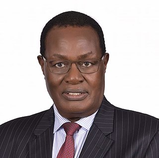
Christopher Mogere Obure is a Kenyan politician. He belongs to the Orange Democratic Movement and was elected to represent the Bobasi Constituency in the National Assembly of Kenya in the December 2007 parliamentary election. He was born in Boigesa Village on 29 September 1943. He worked for Bata Shoe Company and Kenya Breweries Limited before joining politics. He was the Minister of Public Works in the Government of National Unity. He was the first Senator of Kisii County. Obure is also well remembered as the first non-Luo player to be recruited in Gor Mahia F.C, and was among the squad which played during the club's inaugural season in 1968 and 1969.
Sabatia Constituency is an electoral constituency in Western Kenya. It is one of five constituencies in Vihiga County. The constituency was established for the 1988 elections. It has a population of 131,628.
Nyaribare Chache is an electoral constituency in Kenya. It is one of nine constituencies in Kisii County. The constituency was established for the 1988 elections from the larger Nyaribari Constituency to form two constituencies of Nyaribari Chache and Masaba.
Ugenya Constituency is an electoral constituency in Kenya, established for the 1963 elections. It is one of six constituencies of Siaya County. based on the 2019 census report by the Kenya National Bureau of Statistics (KNBS), Ugenya is home to 134,354 people. The first Professor from Ugenya was Prof. Henry Odera Oruka. It is also home to Kenyan most famous senior council and the incumbent governor of Siaya County Bob James Orengo.
Kitutu Masaba is an electoral constituency in Kenya. It was known as Kitutu East Constituency from 1963 to 1988. It is one of four constituencies of Nyamira County. The constituency renamed to Kitutu Masaba prior to the 1988 elections.
Cherangany Constituency, comprises the larger Trans Nzoia East District; otherwise known as Cherangani Sub-County, with an approximate area of 556.9 square km. It is an electoral constituency in Kenya, which was established/created for the 1988 general election.
South Mugirango is an electoral constituency in Kenya. It is one of nine constituencies in Kisii County. The constituency was established for the 1988 elections.
Makueni Constituency is an electoral constituency in Kenya. It is one of six constituencies in Makueni County. The constituency was established for the 1966 elections.Its current MP is Daniel Kitonga Maanzo of Wiper party who is also vying for Makueni Senate.
Mwala Constituency is an electoral constituency in Kenya. The estimate terrain elevation above sea level is 834 meters. It is one of eight constituencies in Machakos County. The constituency was established for the 1988 elections. The constituency has seven wards, all electing councilors for the Masaku County Council.
Bonchari is an electoral constituency in Kisii County. It is one of nine constituencies in the county. The constituency was established for the 1988 elections. It has four wards namely; Riana, Bomorenda, Bomariba and Bogiakumu.
Nyaribari Masaba is an electoral constituency in Kenya. It is one of nine constituencies in Kisii County. The constituency was established for the 1988 elections.
North Mugirango is one of four constituencies in Nyamira County. In 1966 the North Mugirango Constituency was split into West Mugirango and a smaller North Mugirango. The name was changed to Borabu / North Mugirango Constituency in 1974. In 1987 the name changed back to North Mugirango. Prior to 2013, it was formally known as North Mugirango (Borabu) Constituency.
Mandera West Constituency is an electoral constituency in Kenya that was established for the 1966 elections. It is one of six constituencies in Mandera County. It has five wards, all electing councillors to the Mandera County Assembly.
West Mugirango Constituency is an electoral constituency in Kenya. It is one of four constituencies of Nyamira County. The constituency was established for the 1966 elections from what was a larger North Mugirango Constituency.
Uriri is an electoral constituency in Kenya. It is one of eight constituencies of Migori County. There are five wards in the constituency, all electing councillors to the Migori County council. The constituency was established for the 1997 elections. Its mainly inhabited by two ethnic tribes namely Luo and the Abaluhya, who live harmoniously, with kiswahili being the major language in this sub county region.
Suba South, formerly Gwasi is an electoral constituency in Kenya. It is one of eight constituencies in Homa Bay County. The current member of Parliament is Caroli Omondi. He was elected on an ODM ticket.
References
- ↑ Center for Multiparty Democracy: Politics and Parliamentarians in Kenya 1944–2007 Archived October 28, 2008, at the Wayback Machine
- ↑ Electoral Commission of Kenya: Registered voters per polling station by electoral area/ward and constituency Archived September 29, 2007, at the Wayback Machine
- ↑ "County Governments Act No. 17 of 2012" (PDF). Law Society of Kenya. p. 39. Retrieved 4 November 2022.