Related Research Articles

The geography of Kenya is diverse, varying amongst its 47 counties. Kenya has a coastline on the Indian Ocean, which contains swamps of East African mangroves. Inland are broad plains and numerous hills. Kenya borders South Sudan to the northwest, Uganda to the west, Somalia to the east, Tanzania to the south, and Ethiopia to the north.

Rift Valley Province of Kenya, bordering Uganda, was one of Kenya's eight provinces, before the Kenyan general election, 2013. Rift Valley Province was the largest and one of the most economically important provinces in Kenya. It was dominated by the Kenya Rift Valley which passes through it and gives the province its name. According to the 2009 Census, the former province covered an area of 182,505.1 square kilometres and would have had a population of 10,006,805, making it the largest and most populous province in the country. The bulk of the provincial population inhabited a strip between former Nairobi and Nyanza Province. The capital was the town of Nakuru.

These lists cover volcanoes by type and by location.

Mount Elgon is an extinct shield volcano on the border of Uganda and Kenya, north of Kisumu and west of Kitale. The mountain's highest point, named "Wagagai", is located entirely within Uganda. Although there is no verifiable evidence of its earliest volcanic activity, geologists estimate that Mount Elgon is at least 24 million years old, making it the oldest extinct volcano in East Africa. The mountain's name originates from its Maasai name, Elgonyi.

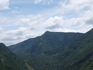
Mount Longonot is a stratovolcano located southeast of Lake Naivasha in the Great Rift Valley of Kenya, Africa. It is thought to have last erupted in the 1860s. Its name is derived from the Maasai word Oloonong'ot, meaning "mountains of many spurs" or "steep ridges".

Rusinga Island, with an elongated shape approximately 10 miles (16 km) from end to end and 3 miles (5 km) at its widest point, lies in the eastern part of Lake Victoria at the mouth of the Winam Gulf. Part of Kenya, it is linked to Mbita Point on the mainland by a causeway.
Korosi is a shield volcano located in the Gregory Rift at the northern end of Lake Baringo, Kenya.

A complex volcano, also called a compound volcano or a volcanic complex, is a mixed landform consisting of related volcanic centers and their associated lava flows and pyroclastic rock. They may form due to changes in eruptive habit or in the location of the principal vent area on a particular volcano. Stratovolcanoes can also form a large caldera that gets filled in by a lava dome, or else multiple small cinder cones, lava domes and craters may develop on the caldera's rim.

Marsabit is a 6300 km2 basaltic shield volcano in Kenya, located 170 km east of the center of the East African Rift, in Marsabit County near the town of Marsabit. This was primarily built during the Miocene, but some lava flows and explosive maar-forming eruptions have occurred more recently. At least two of the maars host crater lakes.
Mount Suswa is a shield volcano in the Great Rift Valley, Kenya. It is located between Narok and Nairobi, the capital of Kenya. The northwestern part of Mount Suswa is in Narok County, while the eastern and southern part are in Kajiado County. The town with the same name, Suswa, is just northwest of the mountain and it is the main access point for visits to the mountain.

Menengai Crater is a massive shield volcano with one of the biggest calderas in the world, in the Great Rift Valley, Kenya. It is the largest volcano caldera in Kenya and the second largest volcano caldera in Africa. Volcanic formed rich loam soils enrich the adjacent farmland arounds its flanks. The crater is on the floor of the Rift Valley. The volcano formed about 200,000 years ago and the prominent 12 x 8 km caldera formed about 8000 years ago. The caldera floor is covered with numerous post caldera lava flows. The Menengai volcano is considered one of the best-preserved Krakatau-style calderas in the world. Menengai has very little sediment in the caldera which is a thick mass of lava boulders and inaccessible ridges. Volcanic activity continues and a current project under the GDC is at an advanced stage towards geothermal power generation.
Mount Homa is a mountain located in western Kenya. It forms a broad peninsula on the southern shore of Winam Gulf, an extension of Lake Victoria. This peninsula defines Homa Bay and the mountaintop is about 20 kilometres (12 mi) north of the town of that name.
Paka is a shield volcano located in the Great Rift Valley, Kenya. Geothermal activity is widespread at Paka. Paka means "ochre" in Pokot.

Namarunu is a shield volcano located in the Great Rift Valley, Kenya.
Emuruangogolak is an active shield volcano straddling the Gregory Rift in Kenya, in Eastern Africa. It has a 3.5-by-5.0-kilometre caldera on its summit. The last known eruption was a trachyte flow which occurred in 1910. Steam vents and fumarolic activity continues from fissures within the caldera and along the flanks of the volcano. Several maar lakes exist in the rift valley adjacent to the volcano. The volcano's summit is at 1,285 metres (4,216 ft) elevation, and its formation is calculated to have been 38,000 years ago.
The Barrier is an active shield volcano located in the north of Kenya. It is last known to have erupted in 1921.

The Great Rift Valley is part of an intra-continental ridge system that runs through Kenya from north to south. It is part of the Gregory Rift, the eastern branch of the East African Rift, which starts in Tanzania to the south and continues northward into Ethiopia. It was formed on the "Kenyan Dome" a geographical upwelling created by the interactions of three major tectonics: the Arabian, Nubian, and Somalian plates. In the past, it was seen as part of a "Great Rift Valley" that ran from Madagascar to Syria. Most of the valley falls within the former Rift Valley Province.
Mount Silali is a dormant volcano in the Gregory Rift Valley, near Kapedo, Kenya. Silali is south of the Suguta Valley, which reaches northward to Lake Turkana, and is about 70 kilometres (43 mi) north of Lake Baringo.
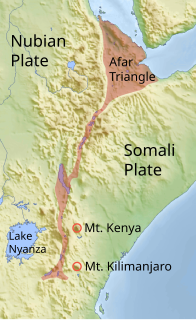
The Gregory Rift is the eastern branch of the East African Rift fracture system. The rift is being caused by the separation of the Somali plate from the Nubian plate, driven by a thermal plume. Although the term is sometimes used in the narrow sense of the Kenyan Rift, the larger definition of the Gregory Rift is the set of faults and grabens extending southward from the Gulf of Aden through Ethiopia and Kenya into Northern Tanzania, passing over the local uplifts of the Ethiopian and Kenyan domes. Ancient fossils of early hominins, the ancestors of humans, have been found in the southern part of the Gregory Rift.
References
- ↑ For a more comprehensive list of volcanoes and craters in Kenya, see sw:Orodha ya volkeno nchini Kenya
- Siebert L, Simkin T (2002–present). Volcanoes of the World: an Illustrated Catalog of Holocene Volcanoes and their Eruptions. Smithsonian Institution, Global Volcanism Program Digital Information Series, GVP-3 (http://www.volcano.si.edu).
- Volcanoes of Kenya Volcano Alive, Retrieved on 2 November 2007
