
A volcano is a rupture in the crust of a planetary-mass object, such as Earth, that allows hot lava, volcanic ash, and gases to escape from a magma chamber below the surface.

A shield volcano is a type of volcano named for its low profile, resembling a shield lying on the ground. It is formed by the eruption of highly fluid lava, which travels farther and forms thinner flows than the more viscous lava erupted from a stratovolcano. Repeated eruptions result in the steady accumulation of broad sheets of lava, building up the shield volcano's distinctive form.

The Mono–Inyo Craters are a volcanic chain of craters, domes and lava flows in Mono County, Eastern California. The chain stretches 25 miles (40 km) from the northwest shore of Mono Lake to the south of Mammoth Mountain. The Mono Lake Volcanic Field forms the northernmost part of the chain and consists of two volcanic islands in the lake and one cinder cone volcano on its northwest shore. Most of the Mono Craters, which make up the bulk of the northern part of the Mono–Inyo chain, are phreatic volcanoes that have since been either plugged or over-topped by rhyolite domes and lava flows. The Inyo volcanic chain form much of the southern part of the chain and consist of phreatic explosion pits, and rhyolitic lava flows and domes. The southernmost part of the chain consists of fumaroles and explosion pits on Mammoth Mountain and a set of cinder cones south of the mountain; the latter are called the Red Cones.

The Lassen volcanic area presents a geological record of sedimentation and volcanic activity in and around Lassen Volcanic National Park in Northern California, U.S. The park is located in the southernmost part of the Cascade Mountain Range in the Pacific Northwest region of the United States. Pacific Oceanic tectonic plates have plunged below the North American Plate in this part of North America for hundreds of millions of years. Heat and molten rock from these subducting plates has fed scores of volcanoes in California, Oregon, Washington and British Columbia over at least the past 30 million years, including these in the Lassen volcanic areas.

Kohala is the oldest of five volcanoes that make up the island of Hawaii. Kohala is an estimated one million years old—so old that it experienced, and recorded, the reversal of Earth's magnetic field 780,000 years ago. It is believed to have breached sea level more than 500,000 years ago and to have last erupted 120,000 years ago. Kohala is 606 km2 (234 sq mi) in area and 14,000 km3 (3,400 cu mi) in volume, and thus constitutes just under 6% of the island of Hawaii.

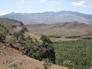
Mount Longonot is a stratovolcano located southeast of Lake Naivasha in the Great Rift Valley of Kenya, Africa. It is thought to have last erupted in the 1860s. Its name is derived from the Maasai word Oloonong'ot, meaning "mountains of many spurs" or "steep ridges".

Sierra Negra is a large shield volcano at the southeastern end of Isabela Island in the Galapagos that rises to an altitude of 1124m. It coalesces with the volcanoes Cerro Azul to the west and Alcedo to the north. It is one of the most active of the Galapagos volcanoes with the most recent historic eruption beginning in June 2018 and continuing through the summer.
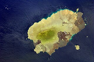
Santiago Island is one of the Galápagos Islands. The island, which consists of two overlapping volcanoes, has an area of 585 square kilometers (226 sq mi) and a maximum altitude of 907 meters (2,976 ft), atop the northwestern shield volcano. The volcano in the island's southeast erupted along a linear fissure and is much lower. The oldest lava flows on the island date back to 750,000 years ago.
Lava Forks Provincial Park is a provincial park in northern British Columbia, Canada. It is the site of Canada's most recent volcanic eruption, which occurred in 1904 at Lava Fork.
Thomas Patrick Gilbert Cholmondeley was a Kenyan farmer. He was the great-grandson of the 3rd Baron Delamere, one of the first and most influential British settlers in Kenya, and was heir to the Delamere title at the time of his death, being the eldest son of the 5th Baron Delamere.

Hoodoo Mountain, sometimes referred to as Hoodoo Volcano, is a potentially active stratovolcano in the Northern Interior of British Columbia, Canada. It is located 25 kilometres northeast of the Alaska–British Columbia border on the north side of the Iskut River opposite of the mouth of the Craig River. With a summit elevation of 1,850 metres and a topographic prominence of 900 metres, Hoodoo Mountain is one of many prominent peaks within the Boundary Ranges of the Coast Mountains. Its flat-topped summit is covered by an ice cap more than 100 metres thick and at least 3 kilometres in diameter. Two valley glaciers surrounding the northwestern and northeastern sides of the mountain have retreated significantly over the last hundred years. They both originate from a large icefield to the north and are the sources of two meltwater streams. These streams flow along the western and eastern sides of the volcano before draining into the Iskut River.

MenengaiCrater is a massive shield volcano with one of the biggest calderas in the world, in the Great Rift Valley, Kenya. It is the largest volcano caldera in Kenya and the second largest volcano caldera in Africa. Volcanic formed rich loam soils enrich the adjacent farmland arounds its flanks. The crater is on the floor of the Rift Valley. The volcano formed about 200,000 years ago and the prominent 12 x 8 km caldera formed about 8000 years ago. The caldera floor is covered with numerous post caldera lava flows. The Menengai volcano is considered one of the best-preserved Krakatau-style calderas in the world. Menengai has very little sediment in the caldera which is a thick mass of lava boulders and inaccessible ridges. Volcanic activity continues and a current project under the GDC is at an advanced stage towards geothermal power generation.

Lake Elmenteita is a soda lake, in the Great Rift Valley, about 120 km northwest of Nairobi, Kenya.
The Soysambu Conservancy was created in 2007 as an entity to conserve the flora, fauna and scenery of Soysambu Ranch, which is to the northwest of Gilgil, Rift Valley Province, Kenya. The Conservancy has taken a conservation lease over the ranch, which would be the portal to the proposed Nakuru-Naivasha wildlife corridor. The Conservancy is 48,000 acres (190 km2) and borders the Elmenteita Badlands in the south in the area around Mawe Mbili. On the west it shares a boundary of 12.1 km with Lake Nakuru National Park.
Mawe Mbili is a volcanic rock formation on the northern edge of the Elmenteita Badlands and within the Soysambu Conservancy, in Nakuru County of Rift Valley Province, southern Kenya. The rock formation is located at the base of Scout Hat Hill, about 5 kilometres (3.1 mi) south of Lake Elmenteita and northwest of Nairobi.
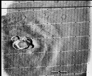
Volcanic activity, or volcanism, has played a significant role in the geologic evolution of Mars. Scientists have known since the Mariner 9 mission in 1972 that volcanic features cover large portions of the Martian surface. These features include extensive lava flows, vast lava plains, and the largest known volcanoes in the Solar System. Martian volcanic features range in age from Noachian to late Amazonian, indicating that the planet has been volcanically active throughout its history, and some speculate it probably still is so today. Both Earth and Mars are large, differentiated planets built from similar chondritic materials. Many of the same magmatic processes that occur on Earth also occurred on Mars, and both planets are similar enough compositionally that the same names can be applied to their igneous rocks and minerals.

James Njenga Karume was a Kenyan businessman and politician. He was born in Elementaita, Nakuru District.
Ol Doinyo Eburru is an active complex of volcanoes in the Great Rift Valley, Kenya to the northwest of Lake Naivasha. It is being exploited for geothermal energy. Soysambu Conservancy is located to the north of the massif, between Lake Elmenteita to the east and Lake Nakuru to the west.

South Island, or Hohnel Island, is a fissure-formed volcanic island and the largest one out of 3 other major islands in Lake Turkana, Kenya. This volcano was discovered in 1888 while it was erupting by Count Teleki, a Hungarian explorer who led the first expedition into the region. It is a part of the Lake Turkana National Parks, which is a UNESCO World Heritage Site.


