Burgich | |
|---|---|
 Burgich Location of Burgich | |
| Coordinates: 1°58′N35°05′E / 1.97°N 35.08°E | |
| Country | Kenya |
| Province | Rift Valley Province |
| Time zone | UTC+3 (EAT) |
Burgich is a settlement in Kenya's Rift Valley Province.
Burgich | |
|---|---|
| Burgich Location of Burgich | |
| Coordinates: 1°58′N35°05′E / 1.97°N 35.08°E | |
| Country | Kenya |
| Province | Rift Valley Province |
| Time zone | UTC+3 (EAT) |
Burgich is a settlement in Kenya's Rift Valley Province.
The highlands provide adequate rainfall for farming and agriculture which is the economic base of the residents of the Rift Valley. Tea from the highlands in the Kericho district enjoys a worldwide reputation, but horticulture is an important part of the district's economy and cattle raising is also practised to a large extent.
The full economic potential of the Rift Valley region is however, far from fully exploited, though the current growth in population and improved education may change this in the near future. People in the province are still mostly rural, but urbanisation is gradually increasing; new cities and towns contain the rural-urban migration and, provided the right policies are instituted, the Rift Valley province will be able to emerge as a national economic and cultural hub.

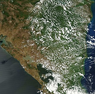
The Great Rift Valley is a series of contiguous geographic trenches, approximately 7,000 kilometres (4,300 mi) in total length, that runs from Lebanon in Asia to Mozambique in Southeast Africa. While the name continues in some usages, it is rarely used in geology as it is considered an imprecise merging of separate though related rift and fault systems.
Nicaragua is a country in Central America, bordering both the Caribbean Sea and the North Pacific Ocean, between Costa Rica and Honduras. Nicaragua is the largest country in Central America in square kilometers.

Rift Valley Province of Kenya, bordering Uganda, was one of Kenya's eight provinces, before the 2013 Kenyan general election. Rift Valley Province was the largest and one of the most economically important provinces in Kenya. It was dominated by the Kenya Rift Valley which passes through it and gives the province its name. According to the 2009 Census, the former province covered an area of 182,505.1 square kilometres and would have had a population of 10,006,805, making it the largest and most populous province in the country. The bulk of the provincial population inhabited a strip between former Nairobi and Nyanza Province. The capital was the town of Nakuru.

The Eastern Highlands, also known as the Manica Highlands, is a mountain range on the border of Zimbabwe and Mozambique. The Eastern Highlands extend north and south for about 300 kilometres (190 mi) through Zimbabwe's Manicaland Province and Mozambique's Manica Province.
Chipinge District is a district in Manicaland Province of eastern Zimbabwe. The administrative headquarters is Chipinge.

The Tugen are a sub tribe of the Kenyan Kalenjin people. They fall under the highland nilotes category. They occupy Baringo County and some parts of Nakuru County and Elgeyo Marakwet County in the former Rift Valley Province. Daniel Arap Moi, the second president of Kenya (1978–2002), came from this sub-tribe. The Tugen people speak the Tugen language. The Tugen population was 197,556 as of 2019.

Chimbu, more frequently spelled Simbu, is a province in the Highlands Region of Papua New Guinea. The province has an area of 6,112 km2 and a population of 376,473. The capital of the province is Kundiawa. Mount Wilhelm, the tallest mountain in Papua New Guinea is on the border of Eastern part of Simbu and the Western part of Madang Province.

Northern Province is one of Zambia's ten provinces. It covers approximately one-sixth of Zambia in land area. The provincial capital is Kasama. The province is made up of 12 districts, namely Kasama District, Chilubi District, Kaputa District, Luwingu District, Mbala District, Mporokoso District, Mpulungu District, Mungwi District, Nsama District, Lupososhi District, Lunte District and Senga Hill District. Currently, only Kasama and Mbala have attained municipal council status, while the rest are still district councils. It is widely considered to be the heartland of the Bemba, one of the largest tribes in Zambia.

Mbeya is a city located in south west Tanzania, Africa, with an urban population of 649,000 in 2023. Mbeya is the capital of the surrounding rural Mbeya region.

The Ethiopian Highlands is a rugged mass of mountains in Ethiopia in Northeast Africa. It forms the largest continuous area of its elevation in the continent, with little of its surface falling below 1,500 m (4,900 ft), while the summits reach heights of up to 4,550 m (14,930 ft). It is sometimes called the "Roof of Northeastern Africa" due to its height and large area. It is the only country in the region with such a high elevated surface. This elevated surface is bisected diagonally by the Great East African Rift System which extends from Syria to Mozambique across the East African Lakes. Most of the Ethiopian Highlands are part of central and northern Ethiopia, and its northernmost portion reaches into Eritrea.

Eastern Province is one of Zambia's ten provinces. The province lies between the Luangwa River and borders with Malawi to the east and Mozambique to the south, from Isoka in the northeast to the north of Luangwa in the south. The provincial capital is Chipata. Eastern province has an area of 51,476 km2 (19,875 sq mi), locally shares border with three other provinces of the country and is divided into fifteen districts.
Njoro is an agricultural town 18 km west south west of Nakuru, Kenya situated on the western rim of the Rift Valley. Njoro town was the headquarters of the former Njoro District, hived off Nakuru District. It was declared as one of the constituencies of Nakuru County in 2010. It has a population of 238,773 people according to the 2019 census report that was published by the Kenya National Bureau of Statistics (KNBS).
Changach is a village in the Keiyo District, Elgeyo-Marakwet County, Kenya. It was formerly in the Rift Valley Province. According to the 2019 census it has a population of 1384 living in 301 households.

The Geology of Pennsylvania consists of six distinct physiographic provinces, three of which are subdivided into different sections. Each province has its own economic advantages and geologic hazards and plays an important role in shaping everyday life in the state. From the southeast corner to the northwest corner of the state, the include: the Atlantic Plain Province province, the Piedmont Province, the New England Province, the Ridge and Valley Province, the Appalachain Province, and the Central Lowlands Province.
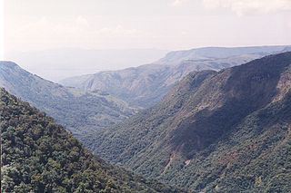
Pungwe River is a 400 km (250 mi) long river in Zimbabwe and Mozambique. It rises below Mount Nyangani in the Eastern Highlands of Zimbabwe and then flows southeastwards through the Manica and Sofala provinces of Mozambique. The Pungwe enters the Urema Valley, the southernmost portion of the Great Rift Valley, where it forms the southern boundary of Gorongosa National Park. The Urema River joins it, and the river follows the rift valley southward. Large seasonal wetlands form around the Pungwe and Urema rivers in the rift valley section. It empties into the Mozambique Channel at Beira, forming a large estuary. It is one of the major rivers of Mozambique and often causes floods.

The North Fly District of the Western Province of Papua New Guinea is the northernmost, smallest, and arguably the most remote of the three districts of the province. It contains the Local-Level Government (LLG) areas of Kiunga Rural, Kiunga Urban, Ningerum Rural, Olsobip Rural and Star Mountains Rural, and the townships of Kiunga, Tabubil, Olsobip and Ningerum.
Kerowagi District is one of six districts of the Simbu Province in Papua New Guinea. Its capital is Kerowagi and the district has three Local Level Government (LLG) areas: Gena-Waugla Rural, Kerowagi Rural, and Kup Rural.
Chebara is a settlement in Kenya's Rift Valley Province.
Dundori or Ndundori is a settlement in Kenya's Rift Valley Province.

During the colonial occupation of Kenya, Black Africans working on farms owned by white settlers were called "squatters" by the British. As of 1945, there were over 200,000 such squatters in the Highlands and more than half were Kikuyu. The Mau Mau rebellion began amongst these squatters in the late 1940s and after independence in the early 1960s, peasants started squatting land in rural areas without the permission of the owner.
| | This Rift Valley Province location article is a stub. You can help Wikipedia by expanding it. |