
The Geography of Kenya is diverse, varying amongst its 47 counties. Kenya has a coastline on the Indian Ocean, which contains swamps of East African mangroves. Inland are broad plains and numerous hills. Kenya borders South Sudan to the northwest, Uganda to the west, Somalia to the east, Tanzania to the south, and Ethiopia to the north.

Kitale is an agricultural town in northern Rift Valley Kenya situated between Mount Elgon and the Cherangany Hills at an elevation of around 1,900 metres (6,200 ft). Its population is 106,187 as of 2009. Kitale is the headquarter town of Trans-Nzoia County. Kitale is reachable by air through Kitale Airport. The postal code for Kitale is 30200.

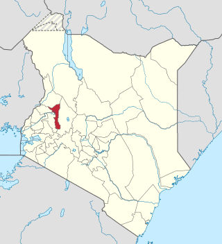
Trans-Nzoia County is a county in the former Rift Valley Province, Kenya, located between the Nzoia River and Mount Elgon, 380 km northwest of Nairobi. At its centre is the town of Kitale which is the capital and largest town. The county borders Bungoma to the west, Uasin Gishu and Kakamega to the south, Elgeyo-Marakwet to the east, West Pokot to the north and the republic of Uganda to the Northwest. Trans Nzoia covers an area of 2495.5 square kilometres.

Uasin Gishu County is one of the 47 counties of Kenya located in the former Rift Valley Province. Eldoret has the county's largest population center as well as its administrative and commercial center. “It lies between longitudes 34 degrees 50’ east and 35 degrees 37’ West and latitudes 0 degrees 03’ South and 0 degrees 55’ North. It is a highland plateau with altitudes falling gently from 2,700 meters above sea level to about 1,500 meters above sea level. The topography is higher to the east and declines gently towards the western border”.
Saiwa Swamp National Park is located near Kitale, in Trans-Nzoia County, Rift Valley Province, Kenya. It is the smallest national park in Kenya, only 3 km2, and was created as habitat for the Sitatunga, a rare aquatic antelope. There are a variety of trees at the national park. Saiwa Swamp National Park is the smallest tour destination park in Kenya, a Sanctuary of the Sitatunga antelope and packed with a lot of wildlife to explore from plants, birds, Insects and reptiles.

Nakuru is a city in the Rift Valley region of the republic of Kenya. It is the capital of Nakuru County, and was formerly the capital of Rift Valley Province. As of 2019, Nakuru had an urban and rural population of 570,674 inhabitants, making it the largest urban center in the Rift Valley, with Eldoret in Uasin Gishu County following closely behind. The city lies along the Nairobi Nakuru Highway, a distance of 160 kilometers from Nairobi, the capital of Kenya. It is the third largest city and fourth largest urban center by metropolitan area in Kenya, behind Nairobi, Mombasa and Kisumu respectively. It lies about 1,850 m above sea level.

Lake Nakuru is one of the Rift Valley lakes at an elevation of 1,754 m (5,755 ft) above sea level. It lies to the south of Nakuru, in the rift valley of Kenya and is protected by Lake Nakuru National Park.

Rift Valley Railways (RVR) was a consortium established to manage the parastatal railways of Kenya and Uganda. The consortium won the bid for private management of the century-old Uganda Railway in 2005. The Kenya-Uganda railway had previously been run by the East African Railways and Harbours Corporation over the period 1948–77. In 2014, RVR moved 1,334 million net tonne kilometers of rail freight, up from 1,185 million net tonne kilometers the previous year. Both Kenya and Uganda terminated their contracts with RVR in mid-2017, with control of their national rail networks reverting to the Kenya Railways Corporation and the Uganda Railways Corporation, respectively.
The Cherang'any Hills are a range of hills in the western highlands of Kenya. The hills are one of Kenya's five main forests and catchment areas. The highlands, the large central plateau, is divided by the Mau Escarpment which rises from the border with Tanzania up to the Cherang'any Hills. The escarpment bounds the plateau that rises to the slopes of Mount Elgon. The Cherangany Hills span three counties namely Trans Nzoia, Elgeyo Marakwet and West Pokot. The highest point of the range is the summit of Nakugen at 3530 m, which can be ascended from the south from parking space at a Kenyan Wildlife Service station, located at 1.16284°N 35.49325°E. Other notable peaks include; Chemnirot (3520 m), Kameleogon (3500 m), Chebon (3375 m), Chepkotet (3370 m), Karelachgelat (3350 m) and Sodang (3211 m). They are home to a marginalized hunter-gatherer community called the Sengwer.
Makutano is a settlement in Kenya's West Pokot County.

Joseph Magutt is a Kenyan academic, diplomat and geopolitical consultant. He was appointed by President Uhuru Kenyatta as Ambassador Extraordinary and Plenipotentiary to the Federal Republic of Germany with accreditation in Romania and Bulgaria in August 2014. His diplomatic appointment under the new constitution was for the first time in the history of Kenya subjected to vetting and approval by parliament of the republic of Kenya.

Tiriki is one of sixteen clans and dialects of the Abaluyia people of Western Kenya. The word Tiriki is also used to refer to their Geographical Location in Hamisi Division, Vihiga County, in the Western province of Kenya. Hamisi Constituency now Hamisi Sub County is one of the longest in Kenya stretching from kiboswa(Ny'angori) to Shiru which borders Kapsabet and Musunji which borders Kakamega Forest. Some also moved to nandi county and occupied aldai and other parts of nandi county.
Lepidochrysops elgonae, the Elgon blue, is a butterfly in the family Lycaenidae. It is found in Kenya. The habitat consists of areas with short grass.
Kipruto Rono Arap Kirwa is a Kenyan politician.
Elgeyo-Marakwet County is one of Kenya's 47 counties. Elgeyo Marakwet County is located in the former Rift Valley Province. Its capital and largest town is Iten. It borders the counties of West Pokot to the north, Baringo County to the east, southeast and south, Uasin Gishu to the southwest and west, and Trans Nzoia to the northwest.

Rift Valley United Football Club is an association football club based in Eldoret, Kenya. The club currently competes in the Kenyan National Super League, and was known as Hotsprings Football Club until 31 March 2014.
Suam, Kenya is a settlement in the Trans-Nzoia County of Kenya. It sits across the Suam River from Suam, Uganda, at the international border between the two countries.
Patrick Simiyu Khaemba is a Kenyan politician. He was the first Governor of Trans-Nzoia County from 2013 to 2022. He was elected into office in 2013 during the Kenya general elections. He is a member of the Coalition for Reforms and Democracy. He was elected under the Forum for the Restoration of Democracy – Kenya.
The Sirikwa culture was the predominant Kenyan hinterland culture of the Pastoral Iron Age, c.2000 BP. Seen to have developed out of the Elmenteitan culture of the East African Pastoral Neolithic c.3300-1200 BP, it was followed in much of its area by the Kalenjin, Maa, western and central Kenyan communities of the 18th and 19th centuries.

During the colonial occupation of Kenya, Black Africans working on farms owned by white settlers were called "squatters" by the British. As of 1945, there were over 200,000 such squatters in the Highlands and more than half were Kikuyu. The Mau Mau rebellion began amongst these squatters in the late 1940s and after independence in the early 1960s, peasants started squatting land in rural areas without the permission of the owner.
