
The Bureau of Land Management (BLM) is an agency within the United States Department of the Interior responsible for administering federal lands. Headquartered in Washington, D.C., and with oversight over 247.3 million acres (1,001,000 km2), it governs one eighth of the country's landmass.

Tooele County is a county in the U.S. state of Utah. As of the 2020 United States Census, the population was 72,698. Its county seat and largest city is Tooele. The county was created in 1850 and organized the following year.

The Black Rock Desert is a semi-arid region of lava beds and playa, or alkali flats, situated in the Black Rock Desert–High Rock Canyon Emigrant Trails National Conservation Area, a silt playa 100 miles (160 km) north of Reno, Nevada that encompasses more than 300,000 acres (120,000 ha) of land and contains more than 120 miles (200 km) of historic trails. It is in the northern Nevada section of the Great Basin with a lakebed that is a dry remnant of Pleistocene Lake Lahontan.

The Bonneville Salt Flats are a densely packed salt pan in Tooele County in northwestern Utah, United States. A remnant of the Pleistocene Lake Bonneville, it is the largest of many salt flats west of the Great Salt Lake. It is public land managed by the Bureau of Land Management and is known for land speed records at the Bonneville Speedway. Access to the Flats is open to the public.
The mustang is a free-roaming horse of the Western United States, descended from horses brought to the Americas by the Spanish. Mustangs are often referred to as wild horses, but because they are descended from once-domesticated animals, they are actually feral horses. The original mustangs were Colonial Spanish horses, but many other breeds and types of horses contributed to the modern mustang, now resulting in varying phenotypes. Some free-roaming horses are relatively unchanged from the original Spanish stock, most strongly represented in the most isolated populations.

Steens Mountain is in the southeastern part of the U.S. state of Oregon, and is a large fault-block mountain. Located in Harney County, it stretches some 50 miles (80 km) north to south, and rises from the west side the Alvord Desert at elevation of about 4,200 feet (1,300 m) to a summit elevation of 9,738 feet (2,968 m). Steens Mountain is not part of a mountain range but is properly a single mountain, the largest of Oregon's fault-block mountains.

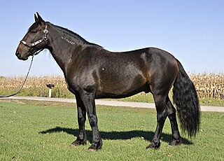
The Spanish Mustang is an American horse breed descended from horses brought from Spain during the early conquest of the Americas. They are classified within the larger grouping of the Colonial Spanish horse, a type that today is rare in Spain. By the early 20th century, most of the once-vast herds of mustangs that had descended from the Spanish horses had been greatly reduced in size. Seeing that these horses were on the brink of extinction, some horseman began making efforts to find and preserve the remaining "Spanish Mustangs" drawing stock from feral and Native American herds, as well as ranch stock. The breed was one of the first to be part of a concerted preservation effort for horses of Spanish phenotype, and a breed registry was founded in 1957.
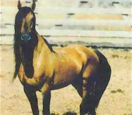
The Kiger mustang is a strain of mustang horse located in the southeastern part of the U.S. state of Oregon. Horses with specific conformation traits discovered in 1977, the name applies only to wild-captured individuals and does not apply to their bred-in-captivity progeny, which are known as Kiger horses. The Bureau of Land Management (BLM) administers two herd management areas for Kiger mustangs in the Burns District—Kiger and Riddle Mountain, in the Steens Mountain area. DNA testing has shown that Kiger mustangs are descended largely from Spanish horses brought to North America in the 17th century, a bloodline thought to have largely disappeared from mustang herds before the Kiger horses were found.

The Henry Mountains is a mountain range located in the southeastern portion of the U.S. state of Utah that runs in a generally north-south direction, extending over a distance of about 30 miles (48 km). They were named by Almon Thompson in honor of Joseph Henry, the first secretary of the Smithsonian Institution. The nearest town of any size is Hanksville, Utah, which is north of the mountains. The Henry Mountains were the last mountain range to be added to the map of the 48 contiguous U.S. states (1872), and before their official naming by Thompson were sometimes referred to as the "Unknown Mountains." In Navajo, the range is still referred to as Dził Bizhiʼ Ádiní.

The Big Maria Mountains are located in the southeastern part of the U.S. state of California, near the Colorado River and Arizona. The range lies between Blythe and Vidal, and west of U.S. Route 95 in California and east of Midland. The mountains are home to the Eagle Nest Mine and reach an elevation of 1,030 meters, (3,379 ft). A power line that runs from Parker Dam to Yuma, Arizona runs through the range. A smaller range, the Little Maria Mountains, lie to the west of the Big Marias.

The Cedar Mountain Wilderness is located in northwestern Utah, United States, just south of Interstate 80. The vegetation on the upper elevations of the Cedar Mountains is dominated by junipers. The foothill and valley regions include mixed desert shrubs. Cheatgrass is prevalent over large areas burned by range fires. The remains of an aragonite mining camp can also be found in the foothills.

The Deseret Peak Wilderness is located in the Stansbury Mountains of Tooele County, Utah, United States near the towns of Tooele and Grantsville, not far from the Great Salt Lake. It is part of the Wasatch-Cache National Forest. This semi-arid wilderness is part of the Great Basin ecosystem. Elevations range from about 6,000 feet to the top of Deseret Peak's limestone escarpment at 11,031 feet (3,362 m). In this high country, with barren Skull Valley to the west, you'll find some springs and intermittent creeks, despite the general dryness of the area.
The Sylvania Mountains Wilderness is a federally designated wilderness area located 30 miles (48 km) east of Bishop in the state of California. The wilderness is 18,677acres in size and is managed by the Bureau of Land Management (BLM). The California Desert Protection Act of 1994 created the Sylvania Mountains Wilderness and was added to the National Wilderness Preservation System. The wilderness is bordered by Nevada stateline on the east, Piper Mountain Wilderness on the west and Death Valley National Park to the south.

The South Fork Eel River Wilderness is a 12,868-acre (5,207 ha) wilderness area located in Mendocino County, California. The wilderness was added to the National Wilderness Preservation System when the United States Congress passed the Northern California Coastal Wild Heritage Wilderness Act in 2006. The Department of the Interior's Bureau of Land Management (BLM) is the agency in charge.
The Pryor Mountains Wild Horse Range is a refuge for a historically significant herd of free-roaming mustangs, the Pryor Mountain mustang, feral horses colloquially called "wild horses", located in the Pryor Mountains of Montana and Wyoming in the United States. The range has an area of 39,650 acres (160.5 km2) and was established in 1968 along the Montana–Wyoming border as the first protected refuge dedicated exclusively for mustangs. It was the second feral horse refuge in the United States. About a quarter of the refuge lies within the Bighorn Canyon National Recreation Area. A group of federal agencies, led by the Bureau of Land Management, administers the range.

The Wild and Free-Roaming Horses and Burros Act of 1971 (WFRHBA), is an Act of Congress, signed into law by President Richard M. Nixon on December 18, 1971. The act covered the management, protection and study of "unbranded and unclaimed horses and burros on public lands in the United States."

The Pryor Mountain mustang is a substrain of mustang considered to be genetically unique and one of the few strains of horses verified by DNA analysis to be descended from the original Colonial Spanish horses brought to the Americas by the Spanish. They live on the Pryor Mountains Wild Horse Range located in the Pryor Mountains of Montana and Wyoming in the United States, and are the only mustang herd remaining in Montana, and one of sixteen in Wyoming. They are protected by the Wild and Free-Roaming Horses and Burros Act of 1971 (WFRHBA) and managed by the Bureau of Land Management (BLM), who has set the optimum herd number at 120 animals. Genetic studies have revealed that the herd exhibits a high degree of genetic diversity and a low degree of inbreeding, and BLM has acknowledged the genetic uniqueness of the herd. Pryor Mountain Mustangs are relatively small horses, exhibit a natural ambling gait, and domesticated Pryor Mountain mustangs are known for their strength, sure-footedness and stamina. The Pryor Mountains Wild Horse Range is one of the most accessible areas to view feral horse herds in the United States and tourism to the area has increased in recent years.

Management of free-roaming feral and semi-feral horses, on various public or tribal lands in North America is accomplished under the authority of law, either by the government of jurisdiction or efforts of private groups. In western Canada, management is a provincial matter, with several associations and societies helping to manage wild horses in British Columbia and Alberta. In Nova Scotia, and various locations in the United States, management is under the jurisdiction of various federal agencies. The largest population of free-roaming horses is found in the Western United States. Here, most of them are protected under the Wild and Free-Roaming Horses and Burros Act of 1971 (WFRH&BA), and their management is primarily undertaken by the Bureau of Land Management (BLM), but also by the U. S. Forest Service (USFS)
Cold Creek is an unincorporated community in Clark County, Nevada, United States located within the Spring Mountains National Recreation Area and approximately 28 miles by road from the Las Vegas city limits. Cold Creek is named for the stream that flows through the community.

