Wasatch Plateau

Last updated
Wasatch Plateau panorama, November 2009 Wasatch Plateau panorama.jpg
Wasatch Plateau panorama, November 2009

The Wasatch Plateau is a plateau located southeast of the southernmost part of the Wasatch Range in central Utah. It is a part of the Colorado Plateau. [1]
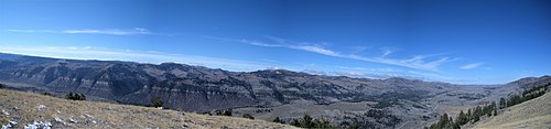
Contents

Geography

The plateau has an elevation of 8,825 feet (2,690 m) [1] and includes an area of 2,792 square miles (7,230 km2). Its highest point in the South Tent Mountain, with an elevation of 11,263 feet (3,433 m). The plateau is roughly bordered by the Spanish Fork Canyon on the north, the Price Canyon on the northeast, the Castle Valley on the east and southeast, Interstate 70 on the south, the Plateau Valley and the Sevier Plateau on the southwest, and the Sanpete Valley on the northwest. The majority of the plateau is within the boundaries of the Manti–La Sal National Forest and is managed by the United States Forest Service. [2] [3]

See also

Related Research Articles

<span class="mw-page-title-main">Rich County, Utah</span> County in Utah, United States

Rich County is a county in the U.S. state of Utah. As of the 2010 United States Census, the population was 2,264, making it the third-least populous county in Utah. Its county seat is Randolph, and the largest town is Garden City. The county was created in 1864. It was named for an early LDS apostle, Charles C. Rich.

<span class="mw-page-title-main">Sanpete County, Utah</span> County in Utah, United States

Sanpete County is a county in the U.S. state of Utah. As of the 2010 United States Census, the population was 27,822. Its county seat is Manti, and its largest city is Ephraim. The county was created in 1850.

<span class="mw-page-title-main">Wasatch Range</span> Mountain range in Utah, United States

The Wasatch Range or Wasatch Mountains is a mountain range in the western United States that runs about 160 miles (260 km) from the Utah-Idaho border south to central Utah. It is the western edge of the greater Rocky Mountains, and the eastern edge of the Great Basin region. The northern extension of the Wasatch Range, the Bear River Mountains, extends just into Idaho, constituting all of the Wasatch Range in that state.

<span class="mw-page-title-main">Colorado Plateau</span> Plateau in the Four Corners region of the Southwest United States

The Colorado Plateau, also known as the Colorado Plateau Province, is a physiographic and desert region of the Intermontane Plateaus, roughly centered on the Four Corners region of the southwestern United States. This province covers an area of 336,700 km2 (130,000 mi2) within western Colorado, northwestern New Mexico, southern and eastern Utah, northern Arizona, and a tiny fraction in the extreme southeast of Nevada. About 90% of the area is drained by the Colorado River and its main tributaries: the Green, San Juan, and Little Colorado. Most of the remainder of the plateau is drained by the Rio Grande and its tributaries.

<span class="mw-page-title-main">Wasatch Front</span> Region in Utah, United States

The Wasatch Front is a metropolitan region in the north-central part of the U.S. state of Utah. It consists of a chain of contiguous cities and towns stretched along the Wasatch Range from approximately Provo in the south to Logan in the north, and containing the cities of Salt Lake City, Bountiful, Layton, and Ogden.

<span class="mw-page-title-main">Little Cottonwood Canyon</span>

Little Cottonwood Canyon lies within the Wasatch-Cache National Forest along the eastern side of the Salt Lake Valley, roughly 15 miles from Salt Lake City, Utah. The canyon is part of Granite, a CDP and "Community Council" designated by Salt Lake County. The canyon is a glacial trough, carved by an alpine glacier during the last ice age, 15,000 to 25,000 years ago. A number of rare and endemic plant species are found in the canyon's Albion Basin. Mountain goats inhabit the surrounding mountains.

<span class="mw-page-title-main">Salt Lake Valley</span> Geographic depression in northern Utah, US, containing Salt Lake City and its suburbs

Salt Lake Valley is a 500-square-mile (1,300 km2) valley in Salt Lake County in the north-central portion of the U.S. state of Utah. It contains Salt Lake City and many of its suburbs, notably Murray, Sandy, South Jordan, West Jordan, and West Valley City; its total population is 1,029,655 as of 2010. Brigham Young said, "this is the right place," when he and his fellow Mormon settlers moved into Utah after being driven out of several states.

<span class="mw-page-title-main">Logan Canyon</span> Canyon in Northeastern Utah

Logan Canyon is in the western United States in northeastern Utah, a canyon that cuts its way through the Bear River Mountains, a branch of the Wasatch Range. It is popular for both summer and winter activities, especially rock-climbing, hiking, camping, fishing, snowmobiling, and skiing, at the Beaver Mountain ski resort. The canyon rises to an elevation of approximately 7,800 feet (2,400 m) above sea level, after a vertical climb of about 2,900 feet (880 m). Just beyond the summit is a steep road leading into Bear Lake Valley and scenic overlooks that provide views of deep blue Bear Lake. The western terminus is at Logan in Cache County and the eastern terminus is at Garden City in Rich County.

<span class="mw-page-title-main">Dixie National Forest</span>

Dixie National Forest is a United States National Forest in Utah with headquarters in Cedar City. It occupies almost two million acres (8,000 km²) and stretches for about 170 miles (270 km) across southern Utah. The largest national forest in Utah, it straddles the divide between the Great Basin and the Colorado River. In descending order of forestland area it is located in parts of Garfield, Washington, Iron, Kane, Wayne, and Piute counties. The majority of forest acreage lies in Garfield County.

<span class="mw-page-title-main">Wellsville Mountains</span>

The Wellsville Mountains are located in northern Utah, United States and are often considered part of the Wasatch Mountains.

Harker Canyon (Tooele County, Utah) Canyon in Tooele County, Utah, United States

Harker Canyon is a canyon in southeastern Tooele County, Utah, United States, about 10 km (6.2 mi) south of the town of Vernon.

<span class="mw-page-title-main">Kokopelli's Trail</span>

The Kokopelli's Trail is a 142-mile (229 km) multi-use trail in Grand County, Utah and Mesa County, Colorado in the western United States. The trail was named in honor of its mythic muse, Kokopelli. The trail was created by the Colorado Plateau Mountain Bike Trail Association (COPMOBA) in cooperation with the Bureau of Land Management (BLM) and the United States Forest Service (USFS) in 1989.

<span class="mw-page-title-main">Lone Peak (Utah)</span>

Lone Peak, a mountain peak southeast of Salt Lake City, Utah, United States is the center of the Lone Peak Wilderness, established in 1978. With an elevation of 11,260 feet (3,430 m), it is one of the taller peaks in the Wasatch Range along the Wasatch Front and tends to be a favorite hike. The first person in recorded history to successfully hike Lone Peak was Richard Bell, Sr. of Riverton, Utah. Richard also lead the first recorded climb of the Lone Peak Cirque. He went on to lead several expeditions and taught the first guides. Bell Canyon is still a common route to the summit, and was named after Richard Bell Sr. following his historic climb. Lone Peak consists almost entirely of quartz monzonite rock of the 30.5 million year old Little Cottonwood Stock. Quartzite and limestone are also found in distal locations on the mountain. The mountain from Little Cottonwood Canyon on the northern end to Corner Canyon on the southern end is called "Mount Jordan", the highest peak of which is Lone Peak, with other lower peaks being Enniss Peak and Bighorn Peak. The Peak ranks 98th on a list of Utah peaks with 500 feet (150 m) topographic prominence.

<span class="mw-page-title-main">Millcreek Canyon (Salt Lake County, Utah)</span>

Millcreek Canyon is a canyon in the Wasatch Mountains and part of Millcreek City on the east side of the Salt Lake Valley, Utah. It is a popular recreation area both in the summer and in the winter. It was named by Brigham Young on August 22, 1847 before all of the mills that were built in and below the densely forested canyon. It is home to two restaurants and six Boy Scout Day Camps.

<span class="mw-page-title-main">Ricks Spring</span> Karst spring in Utah, USA

Ricks Spring is a karst spring, a natural water outflow from a cave in Logan Canyon within the Wasatch-Cache National Forest in northeast Utah. The spring is not an artesian source, but comes from the Logan River. Ricks Spring is the best known of several springs in an underground water network of the area.

<span class="mw-page-title-main">Quitchupah Creek</span>

Quitchupah Creek is a stream draining portions of Emery and Sevier Counties in central Utah, in the western United States. Quitchupah Creek is significant for rock art remains of the Fremont culture that line its banks. Quitchupah is Ute for "animals fare poorly." The drainage area is located within the Colorado River Basin near the south end of the Wasatch Plateau. All drainage from the area flows to Quitchupah Creek or its tributaries, including East Spring Canyon, Water Hollow, and North Fork and flows through Convulsion Canyon.

The Canyon Mountains are a 25-mile (40 km) long mountain range located in the northeast corner of Millard County, Utah; the range is bisected north-south with a southeast border section of Juab County.

Hobble Creek is a stream in Utah County, Utah. Its mouth lies at at its confluence with Utah Lake, at an elevation 4,491 feet (1,369 m). Its source is located at 40°09′45″N111°30′03″W, at the confluence of the Left Fork and Right Fork Hobble Creek in the Wasatch Range. The source lies at an elevation 5,043 feet (1,537 m). The unincorporated community of Hobble Creek occupies the valley of the creek and its Left Fork.

Currant Creek is a stream in eastern Juab County and southern Utah County in northern Utah, United States.

<span class="mw-page-title-main">Guardsman Pass</span> Mountain pass in Utah, US

Guardsman Pass (elevation 9,717 feet is a high mountain pass in the Wasatch Mountains of Utah. The pass is located on the boundaries of the Uinta-Wasatch-Cache National Forest to the west, and the Bonanza Flats backcountry area to the east.

References

  1. 1 2 U.S. Geological Survey Geographic Names Information System: Wasatch Plateau
  2. "Wasatch Plateau". Peakbagger.com. Retrieved 25 Mar 2019.
  3. "Wasatch Plateau". SummitPost.org. Retrieved 25 Mar 2019.

Commons-logo.svg Media related to Wasatch Plateau at Wikimedia Commons

Coordinates: 39°18′41″N111°20′12″W / 39.31139°N 111.33667°W / 39.31139; -111.33667