
Carbon County is a county in the U.S. state of Utah. As of the 2020 United States Census, the population was 20,412. Its county seat and largest city is Price.

Emery County is a county in east-central Utah, United States. As of the 2020 United States Census, the population was 9,825. Its county seat is Castle Dale, and the largest city is Huntington.

Sanpete County is a county in the U.S. state of Utah. As of the 2020 United States Census, the population was 28,437. Its county seat is Manti, and its largest city is Ephraim. The county was created in 1850.

Sevier County is a county in Utah, United States. As of the 2020 United States Census, the population was 21,522. Its county seat and largest city is Richfield.

Emery is a town in Emery County, Utah, United States. The population was 288 at the 2010 census.
Castle Valley may refer to the following places in the United States:
The Richfield Reaper is a weekly newspaper serving the people of south central Utah, printed and published in Richfield, Utah, United States. Its primary areas of coverage include Sevier, Wayne and Piute counties, but is also read in homes in Sanpete and Garfield counties. Available on newsstands Tuesday evenings, it is published and delivered via the US Postal Service on Wednesday.

Interstate 70 (I-70) is a mainline route of the Interstate Highway System in the United States connecting Utah and Maryland. The Utah section runs east–west for approximately 232 miles (373 km) across the central part of the state. Richfield is the largest Utah city served by the freeway, which does not serve or connect any urban areas in the state. The freeway was built as part of a system of highways connecting Los Angeles and the Northeastern United States. I-70 was the second attempt to connect southern California to the east coast of the United States via central Utah, the first being a failed attempt to construct a transcontinental railroad. Parts of that effort were reused in the laying out of the route of I-70.
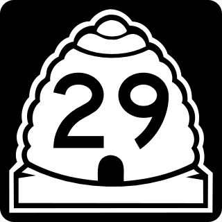
State Route 29 (SR-29) is a state highway in Emery County in the U.S. state of Utah. It runs for 21.732 miles (34.974 km) from the Sanpete-Emery County line near Joe's Valley Reservoir to SR-10 three miles (5 km) north of Castle Dale.

U.S. Route 89 in the U.S. state of Utah is a north-south United States Highway spanning more than 502 miles (807.891 km) through the central part of the state, making it the longest road in Utah. Between Provo and Brigham City, US-89 serves as a local road, paralleling Interstate 15, but the portions from Arizona north to Provo and Brigham City northeast to Wyoming serve separate corridors. The former provides access to several national parks and Arizona, and the latter connects I-15 with Logan, the state's only Metropolitan Statistical Area not on the Interstate.
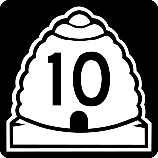
State Route 10 (SR-10) is a State Highway in the U.S. state of Utah. The highway follows a long valley in Eastern Utah between the Wasatch Plateau on the west and the San Rafael Swell on the east.
Mohrland is a ghost town located in Emery County, Utah, United States. Lying in Cedar Creek Canyon near the Carbon County line, Mohrland was Emery County's largest coal mining town, with a history more typical of Carbon County's coal camps than of most Emery County communities.

U.S. Route 6 (US-6) is an east–west United States Numbered Highway through the central part of the U.S. state of Utah. Although it is only about 40 miles (64 km) longer than US-50, it serves more populated areas and, in fact, follows what had been US-50's routing until it was moved to follow Interstate 70 (I-70) in 1976. In 2009, the Utah State Legislature named part of the route the "Mike Dmitrich Highway", named after the Utah state senator, which generated controversy, as the state of Utah had previously joined with all the other states through which US-6 passes in naming all of US-6 the Grand Army of the Republic Highway.
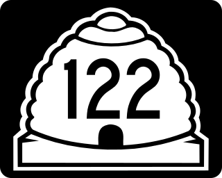
State Route 122 (SR-122) is a state highway in the U.S. state of Utah, connecting the ghost town of Hiawatha with SR-10.
Manti National Forest was established as the Manti Forest Reserve by the General Land Office in Colorado and Utah on May 29, 1903 with 584,640 acres (2,366.0 km2). After the transfer of federal forests to the U.S. Forest Service in 1905, it became a National Forest on March 4, 1907. On July 1, 1915 Nebo National Forest was added. On November 11, 1941, La Sal National Forest was added. On August 28, 1958 the name was changed to Manti-La Sal National Forest. Manti's lands are on the west side of the Colorado River in central Utah, between Manti and Price. In descending order of area, its lands are located in parts of Sanpete (50.3%), Emery (28.96%), Utah (12.59%), Carbon (4.11%), and Sevier (4.05%) counties. As of 30 September 2008 its area was 735,358 acres, representing 57.87% of the combined Manti-La Sal National Forest's total area. There are local ranger district offices in Ephraim, Ferron, and Price, whereas the administrative headquarters of the combined Manti-La Sal National Forest are also in Price.

State Route 24 (SR-24) is a state highway in south central Utah which runs south from Salina through Sevier County then east through Wayne County and north east through Emery County. At a total of 163.294 miles, it is the longest contiguous state route in Utah. A portion of the highway has been designated the Capitol Reef Scenic Byway as part of the Utah Scenic Byways program.

