Castle Dale, Utah

Last updated

Castle Dale, Utah
CastleDaleUtah.jpeg
Castle Dale's city hall
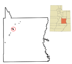
Emery County Utah incorporated and unincorporated areas Castle Dale highlighted.svg
Location within Emery County and the State of Utah
Map of USA UT.svg
Location of Utah in the United States
Coordinates: 39°12′57″N111°1′15″W / 39.21583°N 111.02083°W / 39.21583; -111.02083
Country United States
State Utah
County Emery
Settled1877
Incorporated 1920
Area
[1]
  Total2.23 sq mi (5.79 km2)
  Land2.23 sq mi (5.79 km2)
  Water0.00 sq mi (0.00 km2)
Elevation
5,676 ft (1,730 m)
Population
 (2020) [2]
  Total1,492
  Density670/sq mi (260/km2)
Time zone UTC-7 (Mountain (MST))
  Summer (DST) UTC-6 (MDT)
ZIP code
84513
Area code 435
FIPS code 49-10660 [3]
GNIS feature ID1426380 [4]
Website www.emerycounty.com/castledale/castledale.htm

Castle Dale is a city in northwestern Emery County, Utah, United States. The population was 1,492 at the 2020 census. [2] It is the county seat of Emery County. [5]

Contents

Museum of the San Rafael MuseumOfTheSanRafael.jpg
Museum of the San Rafael

History

The first settlement at Castle Dale was made in 1879. [6]

Geography

Castle Dale lies on the north side of Cottonwood Creek, a tributary of the San Rafael River, in Castle Valley.

According to the United States Census Bureau, the city has a total area of 2.2 square miles (5.6 km2), all land. [1]

Utah State Route 10 passes through the center of town, leading northeast 31 miles (50 km) to Price and southwest 37 miles (60 km) to Interstate 70.

Demographics

Historical population
CensusPop.Note
1890 505
1900 55910.7%
1910 69324.0%
1920 7153.2%
1930 713−0.3%
1940 84118.0%
1950 715−15.0%
1960 617−13.7%
1970 541−12.3%
1980 1,910253.0%
1990 1,704−10.8%
2000 1,657−2.8%
2010 1,630−1.6%
2020 1,492−8.5%
U.S. Decennial Census [7]

As of the census [3] of 2000 there were 1,657 people, 508 households, and 420 families residing in the city. The population density was 887.5 people per square mile (342.1/km2). There were 618 housing units at an average density of 331.0 per square mile (127.6/km2). The racial makeup of the city was 95.47% White, 0.06% African American, 0.66% Native American, 0.54% Asian, 0.18% Pacific Islander, 0.91% from other races, and 2.17% from two or more races. Hispanic or Latino of any race were 2.17% of the population.

Castle Dale has a sizable Afghan community, making up 11.4% of its population as of 2021. [8]

There were 508 households, out of which 49.2% had children under the age of 18 living with them, 72.6% were married couples living together, 7.1% had a female householder with no husband present, and 17.3% were non-families. 15.6% of all households were made up of individuals, and 7.9% had someone living alone who was 65 years of age or older. The average household size was 3.22, and the average family size was 3.60.

In the city, the population was spread out, with 37.2% under 18, 9.7% from 18 to 24, 23.5% from 25 to 44, 21.5% from 45 to 64, and 8.1% who were 65 years of age or older. The median age was 28 years. For every 100 females, there were 105.8 males. For every 100 females aged 18 and over, there were 100.4 males.

The median income for a household in the city was $44,185, and the median income for a family was $48,603. Males had a median income of $40,515 versus $20,294 for females. The per capita income for the city was $14,175. About 6.7% of families and 9.5% of the population were below the poverty line, including 12.4% of those under age 18 and 5.6% of those aged 65 or over.

Climate

Castle Dale has a fairly typical Intermountain West cool semi-arid climate (Köppen BSk). Summer afternoons are hot with intense sunshine, although mornings are pleasantly cool, while winter mornings are frigid even though all but 14.2 afternoons top freezing in an average year. Precipitation, owing to the rain shadows of mountains to the south (blocking monsoonal storms in summer) and west (blocking Pacific storms in winter), is light throughout the year, although there is a slight peak in late summer. The wettest month since record began has been October 2006 with 3.80 inches or 96.5 millimetres, the wettest calendar year 1965 with 14.28 inches or 362.7 millimetres, and the driest 1956 with 3.87 inches or 98.3 millimetres. The dryness of the climate limits snowfall to 16.6 inches or 0.42 metres, with the snowiest month being January 1980 with 24.2 inches or 0.61 metres, and the snowiest year from July 1936 to June 1937 with 47.0 inches or 1.19 metres.

Climate data for Castle Dale 1991-2020, extremes 1899-
MonthJanFebMarAprMayJunJulAugSepOctNovDecYear
Record high °F (°C)67
(19)
70
(21)
83
(28)
89
(32)
97
(36)
104
(40)
107
(42)
103
(39)
102
(39)
88
(31)
81
(27)
67
(19)
107
(42)
Mean daily maximum °F (°C)40.4
(4.7)
46.9
(8.3)
58.4
(14.7)
65.7
(18.7)
74.6
(23.7)
85.3
(29.6)
91.4
(33.0)
88.6
(31.4)
81.1
(27.3)
68.1
(20.1)
53.0
(11.7)
41.0
(5.0)
66.2
(19.0)
Mean daily minimum °F (°C)9.7
(−12.4)
16.1
(−8.8)
24.7
(−4.1)
30.8
(−0.7)
39.5
(4.2)
47.0
(8.3)
54.1
(12.3)
52.2
(11.2)
42.8
(6.0)
31.7
(−0.2)
20.0
(−6.7)
11.2
(−11.6)
31.7
(−0.2)
Record low °F (°C)−34
(−37)
−35
(−37)
−7
(−22)
5
(−15)
13
(−11)
25
(−4)
29
(−2)
30
(−1)
19
(−7)
0
(−18)
−10
(−23)
−28
(−33)
−35
(−37)
Average precipitation inches (mm)0.63
(16)
0.64
(16)
0.59
(15)
0.54
(14)
0.72
(18)
0.45
(11)
0.59
(15)
0.92
(23)
1.03
(26)
0.97
(25)
0.46
(12)
0.47
(12)
8.01
(203)
Average snowfall inches (cm)5.5
(14)
3.3
(8.4)
1.4
(3.6)
0.2
(0.51)
trace0
(0)
0
(0)
0
(0)
0
(0)
0.1
(0.25)
1.2
(3.0)
4.9
(12)
16.6
(41.76)
Average precipitation days (≥ 0.01 in)4.84.73.84.45.03.35.27.35.65.03.34.657.0
Average snowy days (≥ 0.1 in)2.42.00.60.20.000000.10.62.28.1
Source 1: NCEI [9]
Source 2: xmacis [10]

Education

Emery County School District operates public schools in the county. [11]

See also

Related Research Articles

<span class="mw-page-title-main">Markleeville, California</span> Census-designated place in California, United States

Markleeville is a census-designated place (CDP) and the county seat of Alpine County, California, United States. The population was 191 at the 2020 census, down from 210 at the 2010 census.

<span class="mw-page-title-main">Elkhart, Kansas</span> City in Morton County, Kansas

Elkhart is a city in and the county seat of Morton County, Kansas, United States. As of the 2020 census, the population of the city was 1,888. The south edge of the city is the Kansas-Oklahoma state border, and the city is 8.5 miles (13.7 km) from the Kansas-Colorado border.

<span class="mw-page-title-main">Edina, Missouri</span> City in Missouri, United States

Edina is a city and county seat of Knox County, Missouri, United States, between the North and South Forks of the South Fabius River. As of the 2020 census, its population was 1,012.

<span class="mw-page-title-main">Moro, Oregon</span> City in Oregon, United States

Moro is a city in Sherman County, Oregon, United States. The population was 324 at the 2010 census. It is the county seat of Sherman County. It’s currently the least-populous county seat in Oregon. Moro was incorporated on February 17, 1899, by the Oregon Legislative Assembly. It was named for Moro, Illinois.

<span class="mw-page-title-main">Polk Township, Monroe County, Pennsylvania</span> Place in Pennsylvania, United States

Polk Township is a township in Monroe County, Pennsylvania, United States. The population was 7,473 at the 2020 census.

<span class="mw-page-title-main">Price Township, Pennsylvania</span> Place in Pennsylvania, United States

Price Township is a township in Monroe County, Pennsylvania, United States. The population was 3,675 at the 2020 census.

<span class="mw-page-title-main">Price, Utah</span> City in Utah, United States

Price is a city in the U.S. state of Utah and the county seat of Carbon County. The city is home to Utah State University Eastern, as well as the USU Eastern Prehistoric Museum. Price is located within short distances of both Nine Mile Canyon and the Manti-La Sal National Forest.

<span class="mw-page-title-main">Wellington, Utah</span> City in Utah, United States

Wellington is a city in Carbon County, Utah, United States. The population was 1,676 at the 2010 census. The community was settled in 1878 by a band of thirteen Mormons led by Jefferson Tidwell. The town was named for Justus Wellington Seeley, Jr., of the Emery County Court. Many residents commute to nearby Price for their jobs, or work in one of the various coal mines in the area.

<span class="mw-page-title-main">Myton, Utah</span> City in Utah, United States

Myton is a city in Duchesne County, Utah, United States. Established in 1905, Myton had a population of 569 at the 2010 census.

<span class="mw-page-title-main">Clawson, Utah</span> Town in the state of Utah, United States

Clawson is a town in Emery County, Utah, United States. The population was 163 at the 2020 census. The community was named after Rudger Clawson, a Mormon leader.

<span class="mw-page-title-main">Cleveland, Utah</span> Town in the state of Utah, United States

Cleveland is a town in Emery County, Utah, United States. As of the 2010 census, the town population was 464, down from 508 at the 2000 census.

<span class="mw-page-title-main">Elmo, Utah</span> Town in Utah, United States

Elmo is a town in Emery County, Utah, United States. The population was 418 at the 2010 census, up from 368 in 2000.

<span class="mw-page-title-main">Ferron, Utah</span> City in Utah, United States

Ferron is a city in western Emery County, Utah, United States. The population was 1,461 at the 2020 census.

<span class="mw-page-title-main">Huntington, Utah</span> City in Utah, United States

Huntington is a city in northwestern Emery County, Utah, United States. The population was 2,129 at the 2010 census. It is the largest town in Emery County.

<span class="mw-page-title-main">Orangeville, Utah</span> City in Utah, United States

Orangeville is a city in northwestern Emery County, Utah, United States, at the edge of the Manti-La Sal National Forest. The city is at the junction of State Routes 29 and 57, straddling the banks of Cottonwood Creek. The population was 1,470 at the 2010 census.

<span class="mw-page-title-main">Cannonville, Utah</span> Town in Utah, United States

Cannonville is a town in Garfield County, Utah, United States, along Utah Scenic Byway 12. As of the 2010 census, the population was 167, up from 148 at the 2000 census.

<span class="mw-page-title-main">Panguitch, Utah</span> City and county seat in Utah, United States

Panguitch is a city in and the county seat of Garfield County, Utah, United States. The population was 1,725 at the 2020 census. The name Panguitch comes from a Southern Paiute word meaning “Big Fish,” likely named after the plentiful nearby lakes hosting rainbow trout year-round.

<span class="mw-page-title-main">Brian Head, Utah</span> Town in Utah, United States

Brian Head is a town in Iron County, Utah, United States. The population was 83 at the 2010 census, a significant decrease from the 2000 figure of 118.

<span class="mw-page-title-main">Randolph, Utah</span> Town in the state of Utah, United States

Randolph is a town in Rich County, Utah, United States and as of the 2010 census, the town population was 464. It is the county seat of Rich County. Randolph had the highest percentage of people of any city in the country vote for George W. Bush in the 2004 election, at 95.6% Randolph's municipal classification was officially changed from a city to a town on January 1, 2009. The controversial WWASPS boarding school Old West Academy is located just outside Randolph.

<span class="mw-page-title-main">Richfield, Utah</span> City in the United States

Richfield is a city in and the county seat of Sevier County, Utah, United States, and is the largest city in southern-central Utah.

References

  1. 1 2 "2019 U.S. Gazetteer Files". United States Census Bureau. Retrieved August 7, 2020.
  2. 1 2 "Castle Dale city, Utah". United States Census Bureau . Retrieved July 27, 2023.
  3. 1 2 "U.S. Census website". United States Census Bureau . Retrieved January 31, 2008.
  4. "US Board on Geographic Names". United States Geological Survey. October 25, 2007. Retrieved January 31, 2008.
  5. "Find a County". National Association of Counties. Archived from the original on May 31, 2011. Retrieved June 7, 2011.
  6. The Utah Genealogical and Historical Magazine, Volumes 9-10. 1918. p. 82.
  7. "Census of Population and Housing". Census.gov. Retrieved June 4, 2015.
  8. "Castle Dale, Utah.” Castle Dale, Utah (UT 84513, 84537) Profile: Population, Maps, Real Estate, Averages, Homes, Statistics, Relocation, Travel, Jobs, Hospitals, Schools, Crime, Moving, Houses, News, Sex Offenders, www.city-data.com/city/Castle-Dale-Utah.html. Accessed 15 Jan. 2024.
  9. "Summary of Monthly Normals 1991-2020".
  10. "xmACIS2". xmacis.rcc-acis.org.
  11. "2020 CENSUS - SCHOOL DISTRICT REFERENCE MAP: Emery County, UT" (PDF). U.S. Census Bureau . Retrieved March 18, 2023. - Text list

Further reading