
Emery County is a county in east-central Utah, United States. As of the 2020 United States Census, the population was 9,825. Its county seat is Castle Dale, and the largest city is Huntington.
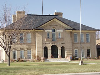
Castle Dale is a city in northwestern Emery County, Utah, United States. The population was 1,492 at the 2020 census. It is the county seat of Emery County.

Emery is a town in Emery County, Utah, United States. The population was 288 at the 2010 census.

Huntington is a city in northwestern Emery County, Utah, United States. The population was 2,129 at the 2010 census. It is the largest town in Emery County.

Green River is a city in Emery County, Utah, United States. The population was 847 at the 2020 census.

The Green River, located in the western United States, is the chief tributary of the Colorado River. The watershed of the river, known as the Green River Basin, covers parts of the U.S. states of Wyoming, Utah, and Colorado. The Green River is 730 miles (1,170 km) long, beginning in the Wind River Mountains of Wyoming and flowing through Wyoming and Utah for most of its course, except for a short segment of 40 miles (64 km) in western Colorado. Much of the route traverses the arid Colorado Plateau, where the river has carved some of the most spectacular canyons in the United States. The Green is slightly smaller than Colorado when the two rivers merge but typically carries a larger load of silt. The average yearly mean flow of the river at Green River, Utah is 6,121 cubic feet (173.3 m3) per second.

Beowawe is a small town in Eureka County, Nevada, United States.

Hiawatha is an unincorporated community and near-ghost town, formerly a coal mining town in southwestern Carbon County, Utah, United States. While the town's former corporate limits were almost entirely within Carbon County, the western part was within the Manti-La Sal National Forest and a very small part extended west into Emery County.

Crystal Geyser is a cold water, carbon dioxide driven geyser located on the east bank of the Green River approximately 9 miles (14 km) downstream from Green River, Utah, United States.

Kelton is a ghost town, just north of the Great Salt Lake, in the Park Valley area of Box Elder County, Utah, United States. The town was inhabited during the period of 1869–1942. Once an important section station on the First transcontinental railroad, Kelton was dependent on the railroad throughout its history. The town suffered serious setbacks in the 1880s when its busy stagecoach route to Boise, Idaho was discontinued, and in the 1900s when the Lucin Cutoff left it off the main rail line. The strongest earthquake in Utah history caused severe damage in 1934, but Kelton ceased to exist only when the rails were completely removed during World War II.

Tucker is a ghost town located near the east end of the Spanish Fork River in Utah County, Utah, United States 7 miles (11 km) below Soldier Summit on U.S. Route 6. It was once an important loading point and construction camp on the Denver and Rio Grande Western Railroad (D&RGW). After the town was abandoned, the state of Utah used the town site for a rest area. In 2009, the site was buried as part of a project to re-align a portion of US-6's western approach to Soldier Summit. To honor the town, the state of Utah built a replacement rest area about 2 miles (3.2 km) downstream from Tucker, called the Tie Fork Rest Area.
Mohrland is a ghost town located in Emery County, Utah, United States. Lying in Cedar Creek Canyon near the Carbon County line, Mohrland was Emery County's largest coal mining town, with a history more typical of Carbon County's coal camps than of most Emery County communities.
Connellsville is a ghost town located high in the mountains of Coal Canyon, near the head of Huntington Canyon in the northwestern corner of Emery County, Utah, United States. A coal mining and coke manufacturing center, Connellsville was the first settlement in what is now Emery County, inhabited from 1874 to 1878. The town now lies beneath the waters of Electric Lake.

Mill Fork is a ghost town located approximately 12 miles (19 km) east of Thistle in Spanish Fork Canyon in Utah County, Utah, United States. Named for its sawmills, Mill Fork was important in the development of the railroad through the canyon. The arched entrance to the small, well-tended Mill Fork Cemetery is a landmark on U.S. Route 6 between the cities of Spanish Fork and Price.
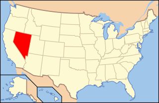
The following is an alphabetical list of articles related to the U.S. State of Nevada.
Lucin is a small railroad community in Box Elder County, Utah, United States, located along the western side of the Great Salt Lake, 162 miles (261 km) northwest of Salt Lake City. Abandoned in 1936 by its original occupants, the community was resettled by four retired railroad workers and their families from 1937 until 1972, and again by four owner-residents in the 1990s.

Silver City is a ghost town located at the mouth of Dragon Canyon on the west flank of the East Tintic Mountains in northeast Juab County in central Utah, United States. It was a silver mining town approximately 90 miles (140 km) south-southwest of Salt Lake City. This area was considered part of the Tintic Mining District and also produced bismuth, copper, gold, and lead. Settlement began with the first mining strikes here in 1869. Silver City was inhabited until 1930, after the mines played out. Jesse Knight, known as the "Mormon Wizard" for his ability to find ore easily, decided to build a smelter in Silver City because it had the flattest ground in all of the Tintic Mining District. Silver City had several mines in 1890, but the mines hit water and were abandoned. Now there is little left other than a few holes where mines were, and a number of tailings piles. The Silver City Cemetery, however, survives and is listed on the National Register of Historic Places.

Moore is an unincorporated community in west central Emery County, Utah, United States, at the edge of the San Rafael Swell.
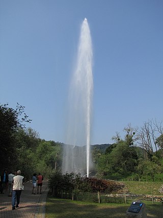
Cold-water geysers are geysers that have eruptions whose water spurts are propelled by CO2-bubbles, instead of the hot steam which drives the more familiar hot-water geysers: The gush of a cold-water geyser is identical to the spurt from a freshly-opened bottle of soda pop. Cold-water geysers look quite similar to their steam-driven counterparts; however, their CO2-laden water often appears whiter and more frothy.
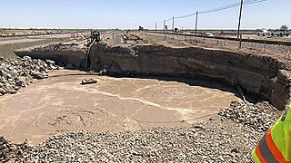
Niland Geyser is a moving mud pot or mud spring outside Niland, California in the Salton Trough in an area of geological instability due to the San Andreas Fault, formed due to carbon dioxide being released underground. It is the only mud pot or mud volcano known to have moved so significantly. The geyser has required costly engineering works since 2018 as it has impinged on the Union Pacific Railroad, California State Route 111, and other infrastructure.


