Elmo, Utah

Last updated
Elmo, Utah
Elmo Utah town hall.jpeg
Town hall and fire station
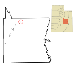
Emery County Utah incorporated and unincorporated areas Elmo highlighted.svg
Location in Emery County and the state of Utah
Map of USA UT.svg
Location of Utah in the United States
Coordinates: 39°23′26″N110°48′58″W / 39.39056°N 110.81611°W / 39.39056; -110.81611 Coordinates: 39°23′26″N110°48′58″W / 39.39056°N 110.81611°W / 39.39056; -110.81611
Country United States
State Utah
County Emery
Settled1908
Incorporated 1935
Area
[1]
  Total0.70 sq mi (1.83 km2)
  Land0.70 sq mi (1.83 km2)
  Water0.00 sq mi (0.00 km2)
Elevation
5,692 ft (1,735 m)
Population
 (2010)
  Total418
  Estimate 
(2019) [2]
402
  Density570.21/sq mi (220.12/km2)
Time zone UTC-7 (Mountain (MST))
  Summer (DST) UTC-6 (MDT)
ZIP code
84521
Area code 435
FIPS code 49-22540 [3]
GNIS feature ID1427806 [4]

Elmo is a town in Emery County, Utah, United States. The population was 418 at the 2010 census, [5] up from 368 in 2000.

Contents

Geography

Elmo is in northern Emery County, 11 miles (18 km) northeast of Huntington, and 16 miles (26 km) south of Price. According to the United States Census Bureau, the town has a total area of 0.66 square miles (1.7 km2), all land. [5]

Demographics

Historical population
CensusPop.
1920 260
1930 30517.3%
1940 198−35.1%
1950 170−14.1%
1960 1752.9%
1970 141−19.4%
1980 300112.8%
1990 267−11.0%
2000 36837.8%
2010 41813.6%
2019 (est.)402 [2] −3.8%
U.S. Decennial Census [6]

As of the census [3] of 2000, there were 368 people, 112 households, and 93 families residing in the town. The population density was 597.9 people per square mile (229.2/km2). There were 120 housing units at an average density of 195.0 per square mile (74.7/km2). The racial makeup of the town was 96.74% White, 0.27% African American, 0.54% Native American, 0.54% Pacific Islander, and 1.90% from two or more races. Hispanic or Latino of any race were 4.35% of the population.

There were 112 households, of which 42.9% had children under 18 living with them, 75.0% were married couples living together, 5.4% had a female householder with no husband present, and 16.1% were non-families. 16.1% of all households were made up of individuals, and 10.7% had someone living alone who was 65 years of age or older. The average household size was 3.11, and the average family size was 3.43.

In the town, the population was spread out, with 30.4% under 18, 11.1% from 18 to 24, 20.4% from 25 to 44, 20.9% from 45 to 64, and 17.1% who were 65 years of age or older. The median age was 35 years. For every 100 females, there were 96.8 males. For every 100 females aged 18 and over, there were 92.5 males.

The median income for a household in the town was $33,750, and the median income for a family was $41,250. Males had a median income of $45,000 versus $18,333 for females. The per capita income was $12,861. About 9.1% of families and 11.2% of the population were below the poverty line, including 19.6% of those under age 18 and 1.9% of those aged 65 or over.

Related Research Articles

<span class="mw-page-title-main">St. Elmo, Illinois</span> City in Illinois, United States

St. Elmo is a city in Fayette County, Illinois, United States. The population was 1,426 at the 2010 census. St. Elmo was established in 1871.

<span class="mw-page-title-main">Smyrna, Maine</span> Town in Maine, United States

Smyrna is a town in Aroostook County, Maine, United States. The population was 439 at the 2020 census.

<span class="mw-page-title-main">West Gardiner, Maine</span> Town in Maine, United States

West Gardiner is a town in Kennebec County, Maine, United States. The population was 3,671 at the 2020 census. West Gardiner is included in the Augusta, Maine micropolitan New England City and Town Area.

Ripley is a town in Somerset County, Maine, United States. The community was named after Brigadier General Eleazer Wheelock Ripley of the War of 1812. The population was 484 at the 2020 census.

<span class="mw-page-title-main">Elmo, Missouri</span> City in Missouri, United States

Elmo is a city in Nodaway County, Missouri, United States. The population was 168 at the 2010 census.

<span class="mw-page-title-main">Paradise, Utah</span> Town in Utah, United States

Paradise is a town located in the southern part of Cache County, Utah, United States. The population was 904 at the 2010 census. It is included in the Logan, Utah-Idaho Metropolitan Statistical Area.

<span class="mw-page-title-main">Trenton, Utah</span> Town in Utah, United States

Trenton is a town in Cache County, Utah, United States. The population was 464 at the 2010 census. It is included in the Logan, Utah-Idaho (partial) Metropolitan Statistical Area.

<span class="mw-page-title-main">Wellington, Utah</span> City in Utah, United States

Wellington is a city in Carbon County, Utah, United States. The population was 1,676 at the 2010 census. The community was settled in 1878 by a band of thirteen Mormons led by Jefferson Tidwell. The town was named for Justus Wellington Seeley, Jr., of the Emery County Court. Many residents commute to nearby Price for their jobs, or work in one of the various coal mines in the area.

<span class="mw-page-title-main">Castle Dale, Utah</span> City in Utah, United States

Castle Dale is a city in northwestern Emery County, Utah, United States. The population was 1,630 at the 2010 census. It is the county seat of Emery County.

<span class="mw-page-title-main">Clawson, Utah</span> Town in Utah, United States

Clawson is a town in Emery County, Utah, United States. The population was 163 at the 2010 census. The community was named after Rudger Clawson, a Mormon leader.

<span class="mw-page-title-main">Cleveland, Utah</span> Town in Utah, United States

Cleveland is a town in Emery County, Utah, United States. As of the 2010 census, the town population was 464, down from 508 at the 2000 census.

<span class="mw-page-title-main">Ferron, Utah</span> City in Utah, United States

Ferron is a city in western Emery County, Utah, United States. The population was 1,626 at the 2010 census. The 2020 2020 census showed the population at 1,474 residents.

<span class="mw-page-title-main">Orangeville, Utah</span> City in Utah, United States

Orangeville is a city in northwestern Emery County, Utah, United States, at the edge of the Manti-La Sal National Forest. The city is at the junction of State Routes 29 and 57, straddling the banks of Cottonwood Creek. The population was 1,470 at the 2010 census.

<span class="mw-page-title-main">Joseph, Utah</span> Town in Utah, United States

Joseph is a town in Sevier County, Utah, United States. The population was 269 at the 2000 census. The town was named for Joseph Angell Young, an apostle of The Church of Jesus Christ of Latter-day Saints. Joseph was settled in 1871.

<span class="mw-page-title-main">Sigurd, Utah</span> Town in Utah, United States

Sigurd is a town in Sevier County, Utah, United States. The population was 429 at the 2010 census.

<span class="mw-page-title-main">Francis, Utah</span> Town in Utah, United States

Francis is a town in on the western edge of Summit County, Utah, United States. It is part of the Salt Lake City, Utah Metropolitan Statistical Area. The population was 1,077 at the 2010 census.

<span class="mw-page-title-main">Cedar Fort, Utah</span> Town in Utah, United States

Cedar Fort is a town in Utah County, Utah, United States. It is part of the Provo–Orem Metropolitan Statistical Area. The population was 368 at the 2010 census.

<span class="mw-page-title-main">Elk Ridge, Utah</span> City in Utah, United States

Elk Ridge is a city in Utah County, Utah, United States. Named for a herd of elk that wintered in the area, it is part of the Provo–Orem, Utah Metropolitan Statistical Area. The population was 4,687 at the time of the 2020 census. Elk Ridge became a fifth-class city by state law in November 2000.

<span class="mw-page-title-main">Genola, Utah</span> Town in Utah, United States

Genola is a town in Utah County, Utah, United States. It is part of the Provo–Orem Metropolitan Statistical Area. The population was 1,370 at the 2010 census.

<span class="mw-page-title-main">Woodland Hills, Utah</span> City in Utah, United States

Woodland Hills is a city in Utah County, Utah, United States. It is part of the Provo–Orem Metropolitan Statistical Area. The population was 1,521 at the 2020 census. Woodland Hills became a city at the end of 2000.

References

  1. "2019 U.S. Gazetteer Files". United States Census Bureau. Retrieved August 7, 2020.
  2. 1 2 "Population and Housing Unit Estimates". United States Census Bureau. May 24, 2020. Retrieved May 27, 2020.
  3. 1 2 "U.S. Census website". United States Census Bureau . Retrieved 2008-01-31.
  4. "US Board on Geographic Names". United States Geological Survey. 2007-10-25. Retrieved 2008-01-31.
  5. 1 2 "Geographic Identifiers: 2010 Census Summary File 1 (G001): Elmo town, Utah". American Factfinder. U.S. Census Bureau. Archived from the original on February 13, 2020. Retrieved March 31, 2016.
  6. "Census of Population and Housing". Census.gov. Retrieved June 4, 2015.