The company began in 1948 when David P. Flaccus started an offset printing business in Missoula. Over several years the company evolved into an independent publishing company and eventually a distributor for other publishers. The company's largest and most popular series of books is Roadside Geology with 29 titles and sales of over 1 million total copies. Other popular series include Geology Underfoot (7 titles) and Roadside History (18 titles).
In October 2024, The Geological Society of America (GSA) acquired all copyrights and licensing agreements for Mountain Press Publishing Company’s geology series Roadside Geology, Geology Underfoot, and Geology Rocks!, along with select titles from the Earth Science and Young Readers series.[1]
Long Valley Caldera is a depression in eastern California that is adjacent to Mammoth Mountain. The valley is one of the Earth's largest calderas, measuring about 20 mi (32 km) long (east-west), 11 mi (18 km) wide (north-south), and up to 3,000 ft (910 m) deep.
The Alabama Hills are a range of hills and rock formations near the eastern slope of the Sierra Nevada in the Owens Valley, west of Lone Pine in Inyo County, California.
In geology, catastrophism is the theory that the Earth has largely been shaped by sudden, short-lived, violent events, possibly worldwide in scope. This contrasts with uniformitarianism, according to which slow incremental changes, such as erosion, brought about all the Earth's geological features. The proponents of uniformitarianism held that the present was "the key to the past", and that all geological processes throughout the past resembled those that can be observed today. Since the 19th-century disputes between catastrophists and uniformitarians, a more inclusive and integrated view of geologic events has developed, in which the scientific consensus accepts that some catastrophic events occurred in the geologic past, but regards these as explicable as extreme examples of natural processes which can occur.
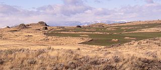
Owens Valley is an arid valley of the Owens River in eastern California in the United States. It is located to the east of the Sierra Nevada, west of the White Mountains and Inyo Mountains, and is split between the Great Basin Desert and the Mojave Desert. The mountain peaks on the West side reach above 14,000 feet (4,300 m) in elevation, while the floor of the Owens Valley is about 4,000 feet (1,200 m), making the valley the deepest in the United States. The Sierra Nevada casts the valley in a rain shadow, which makes Owens Valley "the Land of Little Rain". The bed of Owens Lake, now a predominantly dry endorheic alkali flat, sits on the southern end of the valley.
Glacial Lake Wisconsin was a prehistoric proglacial lake that existed from approximately 18,000 to 14,000 years ago, at the end of the last ice age, in the central part of present-day Wisconsin in the United States.
The Palouse River is a tributary of the Snake River in Washington and Idaho, in the northwest United States. It flows for 167 miles (269 km) southwestwards, primarily through the Palouse region of southeastern Washington. It is part of the Columbia River Basin, as the Snake River is a tributary of the Columbia River.
Massanutten Mountain is a synclinal ridge in the Ridge-and-Valley Appalachians, located in the U.S. state of Virginia. The original Native American name for the ridge is unknown.
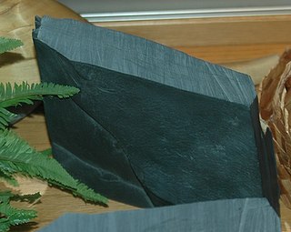
Argillite is a fine-grained sedimentary rock composed predominantly of indurated clay particles. Argillaceous rocks are basically lithified muds and oozes. They contain variable amounts of silt-sized particles. The argillites grade into shale when the fissile layering typical of shale is developed. Another name for poorly lithified argillites is mudstone. These rocks, although variable in composition, are typically high in aluminium and silica with variable alkali and alkaline earth cations. The term pelitic or pelite is often applied to these sediments and rocks. Metamorphism of argillites produces slate, phyllite, and pelitic schist.
A desert pavement, also called reg, serir, gibber, or saï is a desert surface covered with closely packed, interlocking angular or rounded rock fragments of pebble and cobble size. They typically top alluvial fans. Desert varnish collects on the exposed surface rocks over time.
Stephen L. Harris was Professor of Humanities and Religious Studies at California State University, Sacramento. He served there ten years as department chair and was named a Woodrow Wilson Fellow. He received his MA and PhD degrees from Cornell University. Harris was a member of the American Academy of Religion, a fellow at the Westar Institute, a fellow of the Jesus Seminar, and authored several books on religion, some of which are used in introductory university courses.
The geology of Minnesota comprises the rock, minerals, and soils of the U.S. state of Minnesota, including their formation, development, distribution, and condition.
The Withrow Moraine and Jameson Lake Drumlin Field is a National Park Service–designated privately owned National Natural Landmark located in Douglas County, Washington state, United States. Withrow Moraine is the only Ice Age terminal moraine on the Waterville Plateau section of the Columbia Plateau. The drumlin field includes excellent examples of glacially-formed elongated hills.
The Geology of Idaho is complex, with outcroppings of differing ages of volcanics, undifferentiated metamorphics and sedimentary structures.
Friedrich Wilderness Park lies at the southern end of the Texas Hill Country. The park is hilly due to its location on the Balcones escarpment that separates the Texas Hill Country from the flat South Texas region.
The Mississippian Pocono Formation is a mapped bedrock unit in Pennsylvania, Maryland, and West Virginia, in the United States. It is also known as the Pocono Group in Maryland and West Virginia, and the upper part of the Pocono Formation is sometimes called the Burgoon Formation or Burgoon Sandstone in Pennsylvania. The Pocono is a major ridge-former In the Ridge-and-Valley Appalachians of the eastern United States
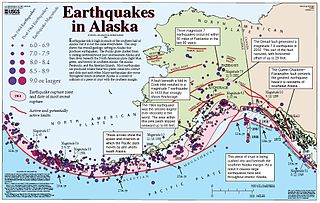
The Denali Fault is a major intracontinental dextral strike-slip fault in western North America, extending from northwestern British Columbia, Canada to the central region of the U.S. state of Alaska.
The following works deal with the cultural, political, economic, military, biographical and geologic history of pre-territorial Montana, Montana Territory and the State of Montana.
Giant current ripples (GCRs), also known as giant gravel bars or giant gravel dunes, are a form of subaqueous dune. They are active channel topographic forms up to 20 m high, which occur within near-thalweg areas of the main outflow routes created by glacial lake outburst floods. Giant current ripple marks are large scale analogues of small current ripples formed by sand in streams. Giant current ripple marks are important features associated with scablands. As a landscape component, they are found in several areas that were previously in the vicinity of large glacial lakes.
Arthur Gibbs Sylvester was an American structural geologist. He was an emeritus professor of geology at the University of California, Santa Barbara and the author of Roadside Geology of Southern California (2016) and the second edition of Geology Underfoot in Southern California (2020), both published by Mountain Press. The Geological Society of America announced he was to be awarded the Structure and Tectonics Division's Career Contribution Award at their 2023 Fall Meeting.
Geology Underfoot is a series of geology guidebooks published by Mountain Press Publishing Company.
This page is based on this Wikipedia article Text is available under the CC BY-SA 4.0 license; additional terms may apply. Images, videos and audio are available under their respective licenses.