Longs Peak is a high and prominent mountain in the northern Front Range of the Rocky Mountains of North America. The 14,259-foot (4346 m) fourteener is located in the Rocky Mountain National Park Wilderness, 9.6 miles (15.5 km) southwest by south of the Town of Estes Park, Colorado, United States. Longs Peak is the northernmost fourteener in the Rocky Mountains of Colorado and the highest point in Boulder County and Rocky Mountain National Park. The mountain was named in honor of explorer Stephen Harriman Long and is featured on the Colorado state quarter.

In geography and geology, a cliff or rock face is an area of rock which has a general angle defined by the vertical, or nearly vertical. Cliffs are formed by the processes of weathering and erosion, with the effect of gravity. Cliffs are common on coasts, in mountainous areas, escarpments and along rivers. Cliffs are usually composed of rock that is resistant to weathering and erosion. The sedimentary rocks that are most likely to form cliffs include sandstone, limestone, chalk, and dolomite. Igneous rocks such as granite and basalt also often form cliffs.

Mount Timpanogos, often referred to as Timp, is the second-highest mountain in Utah's Wasatch Range. Timpanogos rises to an elevation of 11,752 ft (3,582 m) above sea level in the Uinta-Wasatch-Cache National Forest. With 5,270 ft (1,610 m) of topographic prominence, Timpanogos is the 47th-most prominent mountain in the contiguous United States.

Little Cottonwood Canyon lies within the Wasatch-Cache National Forest along the eastern side of the Salt Lake Valley, roughly 15 miles from Salt Lake City, Utah. The canyon is part of Granite, a CDP and "Community Council" designated by Salt Lake County. The canyon is a glacial trough, carved by an alpine glacier during the last ice age, 15,000 to 25,000 years ago. A number of rare and endemic plant species are found in the canyon's Albion Basin. Introduced Mountain goats inhabit the surrounding mountains.

Mount Nebo is the southernmost and highest mountain in the Wasatch Range of Utah, in the United States, and the centerpiece of the Mount Nebo Wilderness, inside the Uinta National Forest. It is named after the biblical Mount Nebo in Jordan, overlooking Israel from the east of the Jordan River, which is said to be the place of Moses' death.

Hunter Mountain is in the towns of Hunter and Lexington, just south of the village of Hunter, in Greene County, New York, United States. At approximately 4,040 feet (1,231 m) in elevation, it is the highest peak in the county and the second-highest peak in the Catskill Mountains.
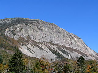
Cannon Mountain is a 4,080-foot (1,240 m) peak in the White Mountains of New Hampshire. It is known for both its technical rock and ice climbing on its cliff face and skiing at Cannon Mountain Ski Area. It was also home to the Old Man of the Mountain, until that formation collapsed on May 3, 2003.

Mount Moosilauke is a 4,802-foot-high (1,464 m) mountain at the southwestern end of the White Mountains in the town of Benton, New Hampshire, United States. It is the tenth highest and most southwesterly of the 4,000 foot summits in the White Mountains.
The Appalachian National Scenic Trail spans 14 U.S. states over its roughly 2,200 miles (3,500 km): Georgia, North Carolina, Tennessee, Virginia, West Virginia, Maryland, Pennsylvania, New Jersey, New York, Connecticut, Massachusetts, Vermont, New Hampshire, and Maine. The southern end is at Springer Mountain, Georgia, and it follows the ridgeline of the Appalachian Mountains, crossing many of its highest peaks and running almost continuously through wilderness before reaching the northern end at Mount Katahdin, Maine.

Lone Peak is a mountain summit in the Wasatch Range southeast of Salt Lake City, Utah, United States, and the center of the Lone Peak Wilderness, established in 1978. With an elevation of 11,260 feet (3,430 m), it is one of the highest peaks in the range and among the most prominent of the Wasatch Front, towering over the Salt Lake City suburb of Draper and easily visible from most of the valley, which makes it a popular destination for hiking and rock climbing.

The Sawtooth Range is a mountain range of the Rocky Mountains in central Idaho, United States, reaching a maximum elevation of 10,751 feet (3,277 m) at the summit of Thompson Peak. It encompasses an area of 678 square miles (1,756 km2) spanning parts of Custer, Boise, Blaine, and Elmore counties, and is bordered to the east by the Sawtooth Valley. Much of the mountain range is within the Sawtooth Wilderness, part of the Sawtooth National Recreation Area and Sawtooth National Forest.

Big Slide Mountain is a mountain in the High Peaks Region of the Adirondack Park in New York. The mountain is the twenty-seventh highest peak in the High Peaks Region. The peak was named for the prominent steep cliff that rises to its summit. It is located in the High Peaks Wilderness Area.
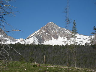
Mount Cramer, at 10,716 feet (3,266 m) is the second highest peak in the Sawtooth Range of Idaho. The summit of Mount Cramer is located on the border of Custer and Boise Counties. The peak is the highest point in Boise County. Mount Cramer is also located within the Sawtooth Wilderness portion of the Sawtooth National Recreation Area. The town of Stanley, Idaho is almost 14 miles (23 km) from Mount Cramer, while the area known as Sawtooth City is nearly 12 miles (19 km) from Mount Cramer. The west side of Mount Cramer drains into the South Fork of the Payette River, while the east side drains to the Salmon River.
Williams Peak, at 10,636 feet (3,242 m) high is the 6th highest peak in the Sawtooth Mountains of Idaho and is located within the Sawtooth Wilderness portion of the Sawtooth National Recreation Area. The peak lies 0.75 mi (1,210 m) north-northeast of Thompson Peak, the highest peak in the range.

The House Range is a north-south trending mountain range in Millard County, of west-central Utah. The House Range was named in 1859 by James H. Simpson. It was named by Simpson because "...of its well-defined stratification and the resemblance of portions of its outline to domes, minarets, houses, and other structures."
Tule Valley is a valley in Millard County, Utah, United States.

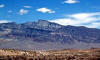
The Pine Valley Mountains are a mountain range in Washington County, Utah, United States, spanning the county north of the city of St. George. The highest point in the range is Signal Peak at 10,365 feet (3,159 m). The mountains are part of Dixie National Forest and are bordered to the south by the Red Cliffs National Conservation Area.
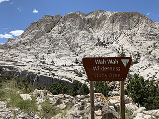
The Crystal Peak Dolomite is a geologic formation in the Wah Wah Mountains of western Utah. It preserves fossils dating to the Middle Ordovician period.
Tule Peak is a summit located in the northwest part of the state of Nevada, United States in the county region of Washoe. It is the highest peak in the Virginia Mountains with a height of 2659.7m.

Sawtooth Mountain is a 9,600-foot elevation (2,926 m) mountain summit in Millard County, Utah, United States.