Wellsville Mountains

Last updated
Wellsville Mountains
Wellsville Mountains.jpg
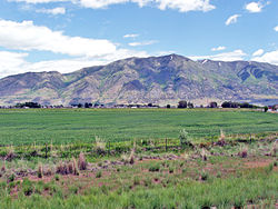
The Wellsville Mountains as seen from the air in mid-September. Box Elder peak and the Wellsville cone are both visible, September 2009.
Highest point
PeakBox Elder Peak [1]
Elevation 9,372 ft (2,857 m)
Coordinates 41°38′08″N112°00′52″W / 41.635624°N 112.014561°W / 41.635624; -112.014561
Dimensions
Length28 mi (45 km)N/S
Width17 mi (27 km)E/W
Area307 sq mi (800 km2)
Naming
Etymology Nearby City of Wellsville
Geography
USA Utah relief location map.svg
Red triangle with thick white border.svg
Wellsville Mountains
Usa edcp relief location map.png
Red triangle with thick white border.svg
Wellsville Mountains
Wellsville Mountains (the United States)
Country United States
State Utah
Parent range Wasatch Range

The Wellsville Mountains are a mountain range in Box Elder and Cache counties in Utah, United States, [2] that is part of the Wasatch Range.

Contents

Description

North Wellsville Mountains from west, at Elwood, Utah with Mendon Peak, June 2008 08-64-City of Elwood,UT,with,Mendon Peak in background as seen from I-15. June 8,2008.jpg
North Wellsville Mountains from west, at Elwood, Utah with Mendon Peak, June 2008

The range separates the Cache Valley from the Wasatch Front (Bear River Valley), as well as form a portion of the border between Box Elder and Cache counties. Nearly all of the water collected by the Wellsville Mountains drains into the Bear River. [3]

While only moderately tall, they are particularly narrow. For this reason, it is often claimed they are one of the steepest mountain ranges in North America. [4] [5] [6] Box Elder (9,372 feet [2,857 m]) and the Wellsville Cone (9,356 feet [2,852 m]) are its two highest peaks. US-89/US-91 traverses Box Elder Canyon, Dry Canyon, and Wellsville Canyon, beginning east of Brigham City as a four-lane highway, curving north then northeast and entering Cache Valley at Wellsville.

The mountains were named for the nearby City of Wellsville. [7]

See also

References

  1. "Box Elder Peak". Peakbagger.com. Retrieved 15 Jan 2013.
  2. "Wellsville Mountains". Geographic Names Information System . United States Geological Survey, United States Department of the Interior.
  3. "Wellsville Mountains". Peakbagger.com. Retrieved January 13, 2013.
  4. Wilderness.net, Retrieved 21 Aug 2007
  5. Bear River Association of Governments Archived 2007-07-04 at the Wayback Machine , Retrieved 12 Aug 2007
  6. Archived 2007-10-08 at the Wayback Machine Publiclands.org, Retrieved 12 Aug 2007
  7. Van Cott, John W. (1990). Utah Place Names: A Comprehensive Guide to the Origins of Geographic Names: A Compilation. Salt Lake City: University of Utah Press. p. 393. ISBN   978-0-87480-345-7. OCLC   797284427 . Retrieved 16 Mar 2018.