Elwood, Utah

Last updated
Elwood, Utah
08-64-City of Elwood,UT,with,Mendon Peak in background as seen from I-15. June 8,2008.jpg
Town of Elwood, with Mendon Peak in background
Box Elder County Utah incorporated and unincorporated areas Elwood highlighted.svg
Location in Box Elder County and the state of Utah
Map of USA UT.svg
Location of Utah in the United States
Coordinates: 41°40′27″N112°8′29″W / 41.67417°N 112.14139°W / 41.67417; -112.14139 Coordinates: 41°40′27″N112°8′29″W / 41.67417°N 112.14139°W / 41.67417; -112.14139
Country United States
State Utah
County Box Elder
Settled1868
Incorporated 1933
Government
  MayorKeenan Nelson
Area
[1]
  Total8.07 sq mi (20.91 km2)
  Land8.06 sq mi (20.88 km2)
  Water0.01 sq mi (0.04 km2)
Elevation
[2]
4,298 ft (1,310 m)
Population
 (2010)
  Total1,034
  Estimate 
(2019) [3]
1,103
  Density136.83/sq mi (52.83/km2)
Time zone UTC-7 (Mountain (MST))
  Summer (DST) UTC-6 (MDT)
ZIP code
84337
Area code 435
FIPS code 49-22760 [4]
GNIS feature ID1427809 [2]
Website www.elwoodtown.com

Elwood is a town in Box Elder County, Utah, United States. The population was 1,034 at the 2010 census. [5]

Contents

Geography

Elwood is located in eastern Box Elder County in the Bear River Valley. The Bear River forms part of the eastern border of the town, and the Malad River forms part of the western border. The town of Deweyville and the city of Honeyville are to the east, and the city of Tremonton is to the northwest.

Interstate Highways 15 and 84 run through the town, with access from Exit 376 (Utah State Route 13, the main local road through the town).

According to the United States Census Bureau, the town has a total area of 7.8 square miles (20.3 km2), of which 0.02 square miles (0.04 km2), or 0.17%, is water. [5]

Demographics

Historical population
CensusPop.
1910 525
1920 64823.4%
1930 520−19.8%
1940 469−9.8%
1950 393−16.2%
1960 345−12.2%
1970 294−14.8%
1980 48163.6%
1990 57519.5%
2000 67817.9%
2010 1,03452.5%
2019 (est.)1,103 [3] 6.7%
U.S. Decennial Census [6]

As of the census [4] of 2000, there were 678 people, 194 households, and 170 families residing in the town. The population density was 88.5 people per square mile (34.2/km2). There were 198 housing units at an average density of 25.8 per square mile (10.0/km2). The racial makeup of the town was 93.95% White, 0.44% Native American, 1.33% Asian, 3.10% from other races, and 1.18% from two or more races. Hispanic or Latino of any race were 4.28% of the population.

There were 194 households, out of which 47.4% had children under 18 living with them, 76.3% were married couples living together, 5.2% had a female householder with no husband present, and 11.9% were non-families. 11.9% of all households were made up of individuals, and 6.7% had someone living alone who was 65 years of age or older. The average household size was 3.49, and the average family size was 3.79.

In the town, the population was spread out, with 37.9% under 18, 8.6% from 18 to 24, 24.0% from 25 to 44, 20.6% from 45 to 64, and 8.8% who were 65 years of age or older. The median age was 29 years. For every 100 females, there were 109.3 males. For every 100 females aged 18 and over, there were 110.5 males.

The median income for a household in the town was $46,406, and the median income for a family was $52,292. Males had a median income of $37,500 versus $21,875 for females. The per capita income for the town was $15,233. About 3.4% of families and 4.3% of the population were below the poverty line, including 4.2% of those under age 18 and 7.4% of those aged 65 or over.

Related Research Articles

<span class="mw-page-title-main">McLeansboro, Illinois</span> City in Illinois, United States

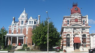
McLeansboro is a city in Hamilton County, Illinois, United States. The population was 2,675 at the 2020 census. The estimated population as of 2018 was 2,773. It is the county seat of Hamilton County.
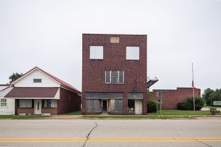
<span class="mw-page-title-main">Elwood, Kansas</span> City in Doniphan County, Kansas

Elwood is a city in Doniphan County, Kansas, United States, located west across the Missouri River from Saint Joseph, Missouri. As of the 2020 census, the population of the city was 1,125.

<span class="mw-page-title-main">Elwood, Nebraska</span> Village in Nebraska, United States

Elwood is a village and the county seat of Gosper County, Nebraska, United States. It is part of the Lexington, Nebraska Micropolitan Statistical Area. The population was 707 at the 2010 census.

<span class="mw-page-title-main">Cornish, Utah</span> Town in Utah, United States

Cornish is a town in Cache County, Utah, United States. The population was 288 at the 2010 census. It is included in the Logan, Utah-Idaho (partial) Metropolitan Statistical Area.

<span class="mw-page-title-main">Lewiston, Utah</span> City in Utah, United States

Lewiston is a city in Cache County, Utah, United States. It is situated at the northern Utah border and borders the state of Idaho. The population was 1,766 at the 2010 census. It is included in the Logan, Utah-Idaho (partial) Metropolitan Statistical Area.

<span class="mw-page-title-main">Paradise, Utah</span> Town in Utah, United States

Paradise is a town located in the southern part of Cache County, Utah, United States. The population was 904 at the 2010 census. It is included in the Logan, Utah-Idaho Metropolitan Statistical Area.

<span class="mw-page-title-main">Trenton, Utah</span> Town in Utah, United States

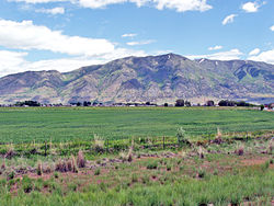
Trenton is a town in Cache County, Utah, United States. The population was 464 at the 2010 census. It is included in the Logan, Utah-Idaho (partial) Metropolitan Statistical Area.

<span class="mw-page-title-main">Henrieville, Utah</span> Town in Utah, United States

Henrieville is a town in Garfield County, Utah, United States, along Utah Scenic Byway 12. As of the 2010 census, the town population was 230, up from 159 at the 2000 census.

<span class="mw-page-title-main">Tropic, Utah</span> Town in Utah, United States

Tropic is a town in Garfield County, Utah, United States, along Utah Scenic Byway 12. As of the 2010 census, the town had a population of 530. Tropic was founded in 1891.

<span class="mw-page-title-main">Joseph, Utah</span> Town in Utah, United States

Joseph is a town in Sevier County, Utah, United States. The population was 269 at the 2000 census. The town was named for Joseph Angell Young, an apostle of The Church of Jesus Christ of Latter-day Saints. Joseph was settled in 1871.

<span class="mw-page-title-main">Redmond, Utah</span> Town in Utah, United States

Redmond is a town in Sevier County, Utah, United States. The population was 730 at the 2010 census. Redmond was first settled in 1876, and named for red mounds to the west of the town.

<span class="mw-page-title-main">Sigurd, Utah</span> Town in Utah, United States

Sigurd is a town in Sevier County, Utah, United States. The population was 429 at the 2010 census.

<span class="mw-page-title-main">Francis, Utah</span> Town in Utah, United States

Francis is a town in on the western edge of Summit County, Utah, United States. It is part of the Salt Lake City, Utah Metropolitan Statistical Area. The population was 1,077 at the 2010 census.

<span class="mw-page-title-main">Henefer, Utah</span> Town in Utah, United States

Henefer is a town in Summit County, Utah, United States. It is part of the Salt Lake City, Utah Metropolitan Statistical Area. The population was 766 at the 2010 census.

<span class="mw-page-title-main">Cedar Fort, Utah</span> Town in Utah, United States

Cedar Fort is a town in Utah County, Utah, United States. It is part of the Provo–Orem Metropolitan Statistical Area. The population was 368 at the 2010 census.

<span class="mw-page-title-main">Elk Ridge, Utah</span> City in Utah, United States

Elk Ridge is a city in Utah County, Utah, United States. Named for a herd of elk that wintered in the area, it is part of the Provo–Orem, Utah Metropolitan Statistical Area. The population was 4,687 at the time of the 2020 census. Elk Ridge became a fifth-class city by state law in November 2000.

<span class="mw-page-title-main">Genola, Utah</span> Town in Utah, United States

Genola is a town in Utah County, Utah, United States. It is part of the Provo–Orem Metropolitan Statistical Area. The population was 1,370 at the 2010 census.

<span class="mw-page-title-main">Woodland Hills, Utah</span> City in Utah, United States

Woodland Hills is a city in Utah County, Utah, United States. It is part of the Provo–Orem Metropolitan Statistical Area. The population was 1,521 at the 2020 census. Woodland Hills became a city at the end of 2000.

<span class="mw-page-title-main">Ellwood City, Pennsylvania</span> Borough in Pennsylvania, United States

Ellwood City is a borough primarily in Lawrence County, Pennsylvania, United States, with a small portion in Beaver County. The population was 7,031 at the 2020 census. Ellwood City lies 30 miles (48 km) northwest of Pittsburgh and 8 miles (13 km) southeast of New Castle within the New Castle micropolitan area. In the past, Ellwood City sustained many heavy industries such as steel-tube mills, steel-car works, building-stone and limestone quarries, foundries and machine shops, and coal-mining.

Elwood, New Jersey Census-designated place in New Jersey, United States

Elwood is an unincorporated community and census-designated place (CDP) located within Mullica Township in Atlantic County, New Jersey, United States. As of the 2010 United States Census, the CDP's population was 1,437. At previous censuses, the area was listed by the U.S. Census Bureau as the Elwood-Magnolia CDP. The area is served as United States Postal Service ZIP code 08217.

References

  1. "2019 U.S. Gazetteer Files". United States Census Bureau. Retrieved August 7, 2020.
  2. 1 2 U.S. Geological Survey Geographic Names Information System: Elwood
  3. 1 2 "Population and Housing Unit Estimates". United States Census Bureau. May 24, 2020. Retrieved May 27, 2020.
  4. 1 2 "U.S. Census website". United States Census Bureau . Retrieved 2008-01-31.
  5. 1 2 "Geographic Identifiers: 2010 Demographic Profile Data (G001): Elwood town, Utah". U.S. Census Bureau, American Factfinder. Archived from the original on February 12, 2020. Retrieved April 24, 2014.
  6. "Census of Population and Housing". Census.gov. Retrieved June 4, 2015.