Rosette, Utah

Last updated

Rosette, Utah
USA Utah location map.svg
Red pog.svg
Rosette
Location of Rosette within the State of Utah
Usa edcp location map.svg
Red pog.svg
Rosette
Rosette (the United States)
Coordinates: 41°49′07″N113°24′47″W / 41.81861°N 113.41306°W / 41.81861; -113.41306
Country United States
State Utah
County Box Elder
Named for Wild roses
Elevation
[1]
5,686 ft (1,733 m)
Time zone UTC-7 (Mountain (MST))
  Summer (DST) UTC-6 (MDT)
ZIP codes
84329
Area code 435
GNIS feature ID1445146 [1]

Rosette is an unincorporated ranching community in northwestern Box Elder County, Utah, United States. [1]

Contents

Historical population
CensusPop.Note
1920 100
1930 77−23.0%
1940 8611.7%
1950 68−20.9%
Source: U.S. Census Bureau [2]

Description

Rosette is located about 4 miles (6.4 km) west of Park Valley, south of the Raft River Mountains. [3]

The community was named by the town's first postmaster, Jonathan Campbell, in 1871. The name refers to the wild roses in the area. [4]

Climate

According to the Köppen Climate Classification system, Rosette has a semi-arid climate, abbreviated "BSk" on climate maps. [5]

Climate data for Rosette, Utah, 1991–2020 normals, extremes 1990–present
MonthJanFebMarAprMayJunJulAugSepOctNovDecYear
Record high °F (°C)55
(13)
62
(17)
74
(23)
83
(28)
90
(32)
100
(38)
102
(39)
100
(38)
97
(36)
92
(33)
69
(21)
63
(17)
102
(39)
Mean maximum °F (°C)46.5
(8.1)
52.3
(11.3)
62.9
(17.2)
73.0
(22.8)
80.8
(27.1)
89.1
(31.7)
95.1
(35.1)
93.5
(34.2)
88.6
(31.4)
76.0
(24.4)
61.6
(16.4)
50.3
(10.2)
95.9
(35.5)
Average high °F (°C)34.6
(1.4)
39.0
(3.9)
47.9
(8.8)
55.0
(12.8)
64.8
(18.2)
75.2
(24.0)
85.7
(29.8)
84.6
(29.2)
74.4
(23.6)
60.3
(15.7)
45.3
(7.4)
34.7
(1.5)
58.5
(14.7)
Daily mean °F (°C)25.1
(−3.8)
29.2
(−1.6)
37.5
(3.1)
43.9
(6.6)
53.1
(11.7)
62.4
(16.9)
72.3
(22.4)
70.9
(21.6)
61.0
(16.1)
47.8
(8.8)
34.9
(1.6)
25.8
(−3.4)
47.0
(8.3)
Average low °F (°C)15.7
(−9.1)
19.3
(−7.1)
27.0
(−2.8)
32.9
(0.5)
41.4
(5.2)
49.6
(9.8)
58.9
(14.9)
57.3
(14.1)
47.6
(8.7)
35.4
(1.9)
24.5
(−4.2)
16.8
(−8.4)
35.5
(1.9)
Mean minimum °F (°C)0.9
(−17.3)
4.9
(−15.1)
13.2
(−10.4)
19.4
(−7.0)
25.7
(−3.5)
34.3
(1.3)
46.8
(8.2)
44.2
(6.8)
31.3
(−0.4)
19.9
(−6.7)
8.3
(−13.2)
−0.2
(−17.9)
−4.2
(−20.1)
Record low °F (°C)−13
(−25)
−9
(−23)
4
(−16)
5
(−15)
14
(−10)
27
(−3)
39
(4)
31
(−1)
20
(−7)
2
(−17)
−9
(−23)
−24
(−31)
−24
(−31)
Average precipitation inches (mm)1.18
(30)
0.92
(23)
0.84
(21)
1.10
(28)
1.50
(38)
0.99
(25)
0.82
(21)
0.75
(19)
1.06
(27)
0.87
(22)
0.60
(15)
1.26
(32)
11.89
(302)
Average precipitation days (≥ 0.01 in)8.16.86.26.99.85.85.45.45.35.15.38.778.8
Source: NOAA [6] [7]

See also

Flag of Utah.svg  Utahportal

Related Research Articles

<span class="mw-page-title-main">Big Bay, Michigan</span> Census-designated place & unincorporated community in Michigan, United States

Big Bay is an unincorporated community in Marquette County of the U.S. state of Michigan. It is a census-designated place (CDP) for statistical purposes and does not have any legal status as an incorporated municipality. As of the 2020 census, the CDP had a population of 257. The community is located within Powell Township near the shore of "Big Bay" on Lake Superior.

<span class="mw-page-title-main">Trenton, Utah</span> Town in Utah, United States

Trenton is a town in Cache County, Utah, United States. The population was 464 at the 2010 census. It is included in the Logan, Utah-Idaho (partial) Metropolitan Statistical Area.

<span class="mw-page-title-main">Altamont, Utah</span> Town in the state of Utah, United States

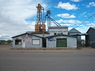
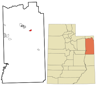
Altamont is a town in Duchesne County, Utah, United States. The population was 225 at the 2010 census, an increase over the 2000 figure of 178.

<span class="mw-page-title-main">Myton, Utah</span> City in Utah, United States

Myton is a city in Duchesne County, Utah, United States. Established in 1905, Myton had a population of 569 at the 2010 census.

<span class="mw-page-title-main">Neola, Utah</span> Census-designated place in Utah, United States

Neola is a census-designated place (CDP) in Duchesne County, Utah, United States. The population was 461 at the 2010 census. Neola was established in 1912.

<span class="mw-page-title-main">Levan, Utah</span> Town in Utah, United States

Levan is a town in Juab County, Utah, United States. As of the 2020 census it had a population of 862.

<span class="mw-page-title-main">Alton, Utah</span> Town in the state of Utah, United States

Alton is a town in northwest Kane County, Utah, United States. The population was 119 at the 2010 census, a decrease from the 2000 figure of 134.

<span class="mw-page-title-main">Big Water, Utah</span> Town in the state of Utah, United States

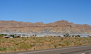
Big Water is a town in Kane County, Utah, United States. The population was 475 at the 2010 census, up from 417 at the 2000 census. It is located 17 miles (27 km) northwest of Page, Arizona, on US-89 near Lake Powell and the Glen Canyon Dam. It was originally called Glen Canyon City and housed workers who built the dam in the 1950s.

<span class="mw-page-title-main">Laketown, Utah</span> Town in the state of Utah, United States

Laketown is a town in Rich County, Utah, United States. The population was 248 at the 2010 census. The town is named for nearby Bear Lake.

<span class="mw-page-title-main">Woodruff, Utah</span> Town in Utah, United States

Woodruff is a town in Rich County, Utah, United States. The population was 180 at the 2010 census.

<span class="mw-page-title-main">Vernon, Utah</span> Town in the state of Utah, United States

Vernon is a town in southeastern Tooele County, Utah, United States.

<span class="mw-page-title-main">Fairfield, Utah</span> Town in the state of Utah, United States

Fairfield is a town in Utah County, Utah, United States. It is part of the Provo–Orem, Utah Metropolitan Statistical Area. It is located in the southwest corner of Cedar Valley about 50 miles (80 km) southwest of Salt Lake City and 5 miles (8.0 km) south of Cedar Fort on Utah State Route 73, west of Utah Lake. The population was 119 at the 2010 census.

<span class="mw-page-title-main">Mapleton, Oregon</span> Unincorporated community in the state of Oregon, United States

Mapleton is an unincorporated community in Lane County, Oregon, United States. It is located on Oregon Route 126 and the Siuslaw River, 45 miles (72 km) west of Eugene and 15 miles (24 km) east of Florence. It is also the western terminus of Oregon Route 36. As of the 2000 census, Mapleton had a total population of 918.

<span class="mw-page-title-main">Echo, Utah</span> CDP in Utah, United States

Echo is a census-designated place located in northwestern Summit County, Utah, United States. The population was 56 at the 2010 census.

<span class="mw-page-title-main">EskDale, Utah</span> Unincorporated community in the state of Utah, United States

Eskdale is an unincorporated community in western Millard County, Utah, United States, just east of the Nevada border.

<span class="mw-page-title-main">Jensen, Utah</span> CDP in Utah, United States

Jensen is a census-designated place in eastern Uintah County, Utah, United States. The population was 412 at the 2010 census. It lies along the Green River and U.S. Route 40, southeast of the city of Vernal, the county seat of Uintah County, and about 17 miles west of the Colorado border. Although Jensen is unincorporated, it has a post office, with the ZIP code of 84035.

Callao is a community in northern Snake Valley, along the border of Juab and Tooele counties, Utah, United States.

<span class="mw-page-title-main">Deseret, Utah</span> CDP in Utah, United States

Deseret is a census-designated place in Millard County, Utah, United States. The population was 353 at the 2010 census. Deseret is located approximately 10 miles (16 km) southwest of Delta, and about 150 miles (240 km) southwest of Salt Lake City. The name Deseret comes from the Book of Mormon.

Lacomb is a census-designated place and unincorporated community in Linn County, Oregon, United States, located about 10 miles (16 km) northeast of Lebanon. It was named in December 1889 by W.J. Turnidge, a son of a pioneer. As of the 2019 Census it had a population of 481.

Angle is an unincorporated community in Piute County, Utah, United States. The community is on Utah State Route 62 9.2 miles (14.8 km) north of Antimony.

References

  1. 1 2 3 "Rosette". Geographic Names Information System . United States Geological Survey, United States Department of the Interior.
  2. "Census of Population and Housing". census.gov. United States Census Bureau . Retrieved November 7, 2011.
  3. "MyTopo Maps - Rosette, UT, USA" (Map). mytopo.com. Trimble Navigation, Ltd. Retrieved March 16, 2018.
  4. Van Cott, John W. (1990). Utah Place Names: A Comprehensive Guide to the Origins of Geographic Names: A Compilation. Salt Lake City: University of Utah Press. p. 321. ISBN   978-0-87480-345-7. OCLC   797284427 . Retrieved March 16, 2018.
  5. Climate Summary for Rosette, Utah
  6. "NOWData – NOAA Online Weather Data". National Oceanic and Atmospheric Administration. Retrieved November 25, 2022.
  7. "Summary of Monthly Normals 1991–2020". National Oceanic and Atmospheric Administration. Retrieved November 29, 2022.

Commons-logo.svg Media related to Rosette, Utah at Wikimedia Commons