Park Valley, Utah

Last updated

Park Valley, Utah
Park Valley, Utah.JPG
Buildings in Park Valley, August 2012
USA Utah location map.svg
Red pog.svg
Park Valley
Location of Park Valley within the State of Utah
Coordinates: 41°49′03″N113°19′45″W / 41.81750°N 113.32917°W / 41.81750; -113.32917
Country United States
State Utah
County Box Elder
Settled1869
Founded byWilliam P. Thomas
Elevation
[1]
5,548 ft (1,691 m)
Time zone UTC-7 (Mountain (MST))
  Summer (DST) UTC-6 (MDT)
ZIP code
84329
Area code 435
GNIS feature ID1431110 [1]

Park Valley is an unincorporated community in north-central Box Elder County, Utah, United States. [1]

Contents

Description

The community lies in the northwestern part of the state, 150 miles (240 km) northwest of the state capital at Salt Lake City, and 100 miles (160 km) west of the county seat at Brigham City. Utah State Route 30 runs through the center of the valley, generally from east to west. The valley is a roughly oval shape of about 30 miles (48 km) in length east to west and about 25 miles (40 km) north to south, covering a major portion of the western end of the county.

Park Valley anchors the northern end of the Great Basin. The Raft River Mountains to the north mark the boundary between the Great Basin and the Snake River Plain. What is called the community of Park Valley includes name locations that used to be nearly separate communities, such as Rosette, Dove Creek, Muddy, Rosebud, and Kelton, as well as ones that have been almost forgotten by time, such as Ten-Mile, Clear Creek, Rosen Valley, Terrace, Golden, Matlin, and other lesser camps along the old railroad grade. Since all of these areas belong to a homogeneous community, they are all known collectively as Park Valley. The valley center, or Park Valley proper, is the community center, which contains the church house, store, hotel, the park, and the schoolhouse.

Historical population
CensusPop.Note
1870 70
1880 275292.9%
1890 196−28.7%
1900 27942.3%
1910 260−6.8%
1920 173−33.5%
1930 167−3.5%
1940 140−16.2%
1950 1421.4%
Source: U.S. Census Bureau [2]

History

In 1826, explorer Jedediah Smith passed through the area. In 1841, the Bartleson-Bidwell Party brought the first wagons through the valley.

While the Transcontinental Railroad coming to Utah did not pass directly through the valley, its proximity played an important part in the settlement and development of the area. Settlement was apparently a result of surveys conducted for several miles on either side of the railroad right-of-way. Even before the rails were joined at Promontory on May 10, 1869, the effect of the railroad on Park Valley had begun. The first permanent settler was William P. (Cotton) Thomas, who migrated from Brigham City in 1869, and developed a cattle ranch near Dove Creek. The heavy growth of trees along the creek and the view of the valley inspired the name.

The town experienced a minor boom in 1890 when gold was discovered. [3]

Climate

According to the Köppen Climate Classification system, Park Valley has a semi-arid climate, abbreviated "BSk" on climate maps. [4]

See also

Flag of Utah.svg  Utahportal

Related Research Articles

<span class="mw-page-title-main">Emery County, Utah</span> County in Utah, United States

Emery County is a county in east-central Utah, United States. As of the 2020 United States Census, the population was 9,825. Its county seat is Castle Dale, and the largest city is Huntington.

<span class="mw-page-title-main">Rich County, Utah</span> County in Utah, United States

Rich County is a county in the U.S. state of Utah. As of the 2020 United States Census, the population was 2,510, making it the third-least populous county in Utah. Its county seat is Randolph, and the largest town is Garden City. The county was created in 1864. It was named for an early LDS apostle, Charles C. Rich.

<span class="mw-page-title-main">Corinne, Utah</span> City in Utah, United States

Corinne is a city in Box Elder County, Utah, United States. The population was 809 at the 2020 census, up from the 2010 figure of 685.

<span class="mw-page-title-main">Perry, Utah</span> City in Utah, United States

Perry is a city in Box Elder County, Utah, United States. The population was 4,512 at the 2010 census.

<span class="mw-page-title-main">Snowville, Utah</span> Town in the state of Utah, United States

Snowville is a town in Box Elder County, Utah, United States. The population was 167 at the 2010 census.

<span class="mw-page-title-main">Providence, Utah</span> City in Utah, United States

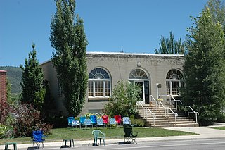
Providence is a city in Cache County, Utah, United States. The population was 7,075 at the 2010 census. It is included in the Logan, Utah-Idaho Metropolitan Statistical Area.

<span class="mw-page-title-main">Farmington, Utah</span> City in Utah, United States

Farmington is a city in Davis County, Utah, United States. The population was 24,531 at the 2020 census. The Lagoon Amusement Park and Station Park transit-oriented retail center are located in Farmington.

<span class="mw-page-title-main">Cedar City, Utah</span> City in the United States

Cedar City is the largest city in Iron County, Utah, United States. It is located 250 miles (400 km) south of Salt Lake City, and 170 miles (270 km) north of Las Vegas on Interstate 15. It is the home of Southern Utah University, the Utah Shakespeare Festival, the Utah Summer Games, the Simon Fest Theatre Co., and other events. As of the 2020 census the city had a population of 35,235, up from 28,857 in the 2010 census.

<span class="mw-page-title-main">Parowan, Utah</span> City in Utah, United States

Parowan is a city in and the county seat of Iron County, Utah, United States. The population was 2,790 at the 2010 census, and in 2018 the estimated population was 3,100.

<span class="mw-page-title-main">Fairview, Utah</span> City in Utah, United States

Fairview is a city in northern Sanpete County, Utah, United States. The population was 1,203 at the 2020 census.

<span class="mw-page-title-main">Coalville, Utah</span> City in the United States

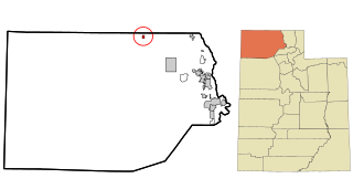
Coalville is a city in and the county seat of Summit County, Utah, United States. It is part of the Salt Lake City, Utah Metropolitan Statistical Area. The population was 1,363 as of the 2010 census. Interstate 80 passes through the town, as well as the Weber River, which flows into Echo Reservoir, just north of Coalville.

<span class="mw-page-title-main">Vernal, Utah</span> City in Utah, United States

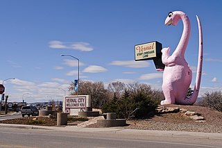
Vernal, the county seat and largest city in Uintah County, is in northeastern Utah, approximately 175 miles (280 km) east of Salt Lake City and 20 miles (32 km) west of the Colorado border. As of the 2020 census, the city population was 10,079. The population has since grown to 10,432 as of the 2022 population estimate.

<span class="mw-page-title-main">Pleasant Grove, Utah</span> City in Utah, United States

Pleasant Grove, originally named Battle Creek, is a city in Utah County, Utah, United States, known as "Utah's City of Trees". It is part of the Provo–Orem Metropolitan Statistical Area. The population was 37,726 at the 2020 Census.

<span class="mw-page-title-main">Mormon Trail</span> Migrant route from Illinois to Salt Lake City, Utah

The Mormon Trail is the 1,300-mile (2,100 km) long route from Illinois to Utah on which Mormon pioneers traveled from 1846–47. Today, the Mormon Trail is a part of the United States National Trails System, known as the Mormon Pioneer National Historic Trail.

<span class="mw-page-title-main">Jordan River (Utah)</span> River feeding the Great Salt Lake, USA

The Jordan River, in the state of Utah, United States, is a river about 51 miles (82 km) long. Regulated by pumps at its headwaters at Utah Lake, it flows northward through the Salt Lake Valley and empties into the Great Salt Lake. Four of Utah's six largest cities border the river: Salt Lake City, West Valley City, West Jordan, and Sandy. More than a million people live in the Jordan Subbasin, part of the Jordan River watershed that lies within Salt Lake and Utah counties. During the Pleistocene, the area was part of Lake Bonneville.

<span class="mw-page-title-main">Sevier River</span> River in central Utah, United States

The Sevier River is a 400-mile (640 km)-long river in the Great Basin of southwestern Utah in the United States. Originating west of Bryce Canyon National Park, the river flows north through a chain of high farming valleys and steep canyons along the west side of the Sevier Plateau before turning southwest and terminating in the endorheic basin of Sevier Lake in the Sevier Desert. It is used extensively for irrigation along its course, with the consequence that Sevier Lake is usually dry.

Blue Creek is a ghost town in the Blue Creek Valley in northeastern Box Elder County, Utah, United States.

<span class="mw-page-title-main">Lake Point, Utah</span> City in Utah, United States

Lake Point is a city on the eastern edge of northern Tooele County, Utah, United States. It is located 17 miles southwest of Salt Lake City International Airport and 11 miles north of Tooele, Utah. At its location on the south shore of the Great Salt Lake, the city is served by Interstate 80 and Utah State Route 36.

<span class="mw-page-title-main">Springville, Utah</span> City in Utah, United States

Springville is a city in Utah County, Utah, United States, that is part of the Provo–Orem metropolitan area. The population was 35,268 in 2020, according to the United States Census. Springville is a bedroom community for commuters who work in the Provo-Orem and Salt Lake City metropolitan areas. Other neighboring cities include Spanish Fork and Mapleton. Springville has the nickname of "Art City" or "Hobble Creek".

<span class="mw-page-title-main">Juab Valley</span> Valley in Juab County, Utah, United States

The Juab Valley is a 40-mile (64 km) long valley located on the eastern edge of Juab County, Utah, United States.

References

  1. 1 2 3 "Park Valley". Geographic Names Information System . United States Geological Survey, United States Department of the Interior.
  2. "Census of Population and Housing". census.gov. United States Census Bureau. Archived from the original on February 8, 2006. Retrieved November 7, 2011.
  3. "Park Valley, Utah Genealogy - FamilySearch Wiki". familysearch.org. Retrieved June 7, 2016.
  4. Climate Summary for Park Valley, Utah

Commons-logo.svg Media related to Park Valley, Utah at Wikimedia Commons