Willard, Utah

Last updated

Willard, Utah
Willard3.jpg
City of Willard, with Willard Bay and the Promontory Mountains in the background
Box Elder County Utah incorporated and unincorporated areas Willard highlighted.svg
Location in Box Elder County and the state of Utah
Map of USA UT.svg
Location of Utah in the United States
Coordinates: 41°24′43″N112°2′23″W / 41.41194°N 112.03972°W / 41.41194; -112.03972
Country Flag of the United States.svg  United States
State Flag of Utah.svg  Utah
County Box Elder
Settled1851
Incorporated 1870
Named for Willard Richards
Area
[1]
  Total7.08 sq mi (18.35 km2)
  Land5.62 sq mi (14.55 km2)
  Water1.47 sq mi (3.80 km2)
Elevation
[2]
4,350 ft (1,326 m)
Population
 (2010)
  Total1,772
  Estimate 
(2019) [3]
1,958
  Density348.58/sq mi (134.58/km2)
Time zone UTC-7 (Mountain (MST))
  Summer (DST) UTC-6 (MDT)
ZIP code
84340
Area code 435
FIPS code 49-84710 [4]
GNIS feature ID1447372 [2]
Website www.willardcity.com

Willard (Shoshoni: Sogo-timp-bow ya) [5] is a city in Box Elder County, Utah, United States. The population was 1,772 at the 2010 census. [6]

Contents

Geography

Willard is located in southeastern Box Elder County and is bordered by the city of Perry to the north and the unincorporated community of South Willard to the south. The east edge of the city is bordered by Cache National Forest in the Wasatch Range, and the west side extends into Willard Bay, a freshwater reservoir built out of the Great Salt Lake. Willard Bay State Park is located within the city limits along the shore of Willard Bay.

Interstate highways 15 and 84 pass through the western side of the city, with access from Exit 357. U.S. Route 89 is the city's Main Street.

According to the United States Census Bureau, the city has a total area of 7.2 square miles (18.6 km2), of which 5.7 square miles (14.7 km2) is land and 1.5 square miles (3.9 km2), or 21.16%, is water. [6]

History

In 1851, several companies of Mormon settlers were sent north from Salt Lake City to a northern bay of the Great Salt Lake called Bear River Bay. In 1957 the US Corps of Engineers built a fresh water lake which is now called Willard Bay. A company of nineteen located on North Willow Creek, 7 miles (11 km) south of the site where Brigham City would be established. Two years later, the infant community relocated two miles further south, and a fort wall was built due to the possibility of attacks by the Shohone and their allies. Willard's first settlers were mostly of Welsh, English, Scottish and Dutch descent. Most were farmers, but some were merchants, carpenters, blacksmiths and school teachers. Historically, the economy of Willard centered on agriculture, with fruit crops being the major product. Gravel excavation and worked stone have also been a significant source of income.

Henry G. Sherwood surveyed North Willow Creek in 1851. The community was renamed Willard in honor of Willard Richards (1804-1854, [7] a recently deceased Apostle of the LDS Church and counselor to Brigham Young, in 1859. Willard received its charter as a city in 1870.

Gifted stonemason Shadrack Jones took advantage of local rock cliffs and the alluvial fan exposed as ancient Lake Bonneville receded. [8] Between 1862 and 1883, he mined the local stone and built single-family homes. Over thirty still stand and many are listed on the National Register of Historic Places as contributing buildings in the Willard Historic District. Other early structures included a brick yard, the first grist mill in Box Elder County, and a number of molasses mills.

Demographics

Historical population
CensusPop.Note
1870 552
1880 412−25.4%
1890 49219.4%
1900 58017.9%
1910 577−0.5%
1920 65112.8%
1930 561−13.8%
1940 541−3.6%
1950 5481.3%
1960 81448.5%
1970 1,04528.4%
1980 1,24118.8%
1990 1,2984.6%
2000 1,63025.6%
2010 1,7728.7%
2019 (est.)1,958 [3] 10.5%
U.S. Decennial Census [9]

As of the census [6] of 2010, there were 1,772 people, 600 households, and 485 families residing in the city. The population density was 310.9 people per square mile (120.5/km2). There were 633 housing units at an average density of 111.1 per square mile (43.1/km2). The racial makeup of the city was 95.4% White, 0.1% African American, 0.3% Native American, 0.8% Asian, 0.1% Pacific Islander, 1.2% from other races, and 2.1% from two or more races. Hispanic or Latino of any race were 3.9% of the population.

There were 600 households, out of which 35.2% had children under the age of 18 living with them, 68.3% were married couples living together, 7.7% had a female householder with no husband present, and 19.2% were non-families. 15.8% of all households were made up of individuals, and 7.3% had someone living alone who was 65 years of age or older. The average household size was 2.95 and the average family size was 3.31.

In the city, the population was spread out, with 28.9% under the age of 18, 8.1% from 18 to 24, 23.8% from 25 to 44, 27.2% from 45 to 64, and 12% who were 65 years of age or older. The median age was 34.3 years. For every 100 females, there were 98.2 males. For every 100 females age 18 and over, there were 99.7 males.

In 2000 [4] the median income for a household in the city was $52,150, and the median income for a family was $57,841. Males had a median income of $40,625 versus $26,364 for females. The per capita income for the city was $17,592. About 5.1% of families and 7.2% of the population were below the poverty line, including 7.9% of those under age 18 and 4.7% of those age 65 or over.

Notable people

See also

Related Research Articles

<span class="mw-page-title-main">Box Elder County, Utah</span> County in Utah, United States

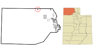
Box Elder County is a county at the northwestern corner of Utah, United States. At the 2020 census, the population was 57,666, up from the 2010 figure of 49,975. Its county seat and largest city is Brigham City. The county was named for the box elder trees that abound in the county.

<span class="mw-page-title-main">Weber County, Utah</span> County in Utah, United States

Weber County is a county in the U.S. state of Utah. As of the 2020 census, the population was 262,223, making it Utah's fourth-most populous county. Its county seat and largest city is Ogden, the home of Weber State University. The county was named for the Weber River.

<span class="mw-page-title-main">Corinne, Utah</span> City in Utah, United States

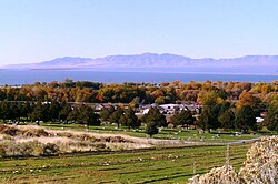
Corinne is a city in Box Elder County, Utah, United States. The population was 809 at the 2020 census, up from the 2010 figure of 685.

<span class="mw-page-title-main">Fielding, Utah</span> Town in Utah, United States

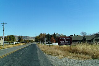
Fielding is a town in Box Elder County, Utah, United States. The population was 455 at the 2010 census.

<span class="mw-page-title-main">Howell, Utah</span> Town in the state of Utah, United States

Howell is a town located in the Blue Creek Valley in northeast Box Elder County, Utah, United States. The population was 245 at the 2010 census.

<span class="mw-page-title-main">Mantua, Utah</span> Town in the state of Utah, United States

Mantua is a town on the eastern edge Box Elder County, Utah, United States. The population of the town was 687 at the 2010 census.

<span class="mw-page-title-main">Perry, Utah</span> City in Utah, United States

Perry is a city in Box Elder County, Utah, United States. The population was 4,512 at the 2010 census.

<span class="mw-page-title-main">Riverside, Utah</span> CDP in Utah, United States

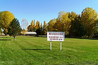
Riverside is a census-designated place (CDP) in Box Elder County, Utah, United States. The population was 760 at the 2010 census.

<span class="mw-page-title-main">South Willard, Utah</span> CDP in Utah, United States

South Willard is a census-designated place (CDP) in Box Elder County, Utah, United States. The population was 1,571 at the 2010 census.

<span class="mw-page-title-main">Cornish, Utah</span> Town in the state of Utah, United States

Cornish is a town in Cache County, Utah, United States. The population was 288 at the 2010 census. It is included in the Logan, Utah-Idaho (partial) Metropolitan Statistical Area.

<span class="mw-page-title-main">Syracuse, Utah</span> City in Utah, United States

Syracuse is a city in Davis County, Utah, United States. It is situated between the Great Salt Lake and Interstate 15, about 30 miles (48 km) north of Salt Lake City. It is part of the Ogden–Clearfield, Utah Metropolitan Statistical Area. The city has seen rapid growth and development since the 1990s. The city population was 24,331 at the time of the 2010 census, an increase of 158.9% since the 2000 census.

<span class="mw-page-title-main">Lynndyl, Utah</span> Town in the state of Utah, United States

Lynndyl is a town in Millard County, Utah, United States. The population was 106 at the 2010 census.

<span class="mw-page-title-main">Joseph, Utah</span> Town in the state of Utah, United States

Joseph is a town in Sevier County, Utah, United States. The population was 269 at the 2000 census. The town was named for Joseph Angell Young, an apostle of the Church of Jesus Christ of Latter-day Saints. Joseph was settled in 1871.

<span class="mw-page-title-main">Redmond, Utah</span> Town in the state of Utah, United States

Redmond is a town in Sevier County, Utah, United States. The population was 730 at the 2010 census. Redmond was first settled in 1876, and named for red mounds to the west of the town.

<span class="mw-page-title-main">Francis, Utah</span> Town in the state of Utah, United States

Francis is a town in on the western edge of Summit County, Utah, United States. It is part of the Salt Lake City, Utah Metropolitan Statistical Area. The population was 1,077 at the 2010 census.

<span class="mw-page-title-main">Woodland Hills, Utah</span> City in Utah, United States

Woodland Hills is a city in Utah County, Utah, United States. It is part of the Provo–Orem Metropolitan Statistical Area. The population was 1,521 at the 2020 census. Woodland Hills became a city at the end of 2000.

<span class="mw-page-title-main">Charleston, Utah</span> Town in Utah, United States

Charleston is a town in Wasatch County, Utah, United States. The population was 415 at the 2010 census.

<span class="mw-page-title-main">Wallsburg, Utah</span> Town in the state of Utah, United States

Wallsburg is a town in Wasatch County, Utah, United States. It is part of the Salt Lake City metropolitan area. The population was 250 at the 2010 census. Wallsburg was established in 1861, and was named for William Madison Wall.

<span class="mw-page-title-main">Leeds, Utah</span> Town in Washington County, Utah

Leeds is a town in Washington County, Utah, United States. The population was 820 at the 2010 census.

<span class="mw-page-title-main">Torrey, Utah</span> Town in the state of Utah, United States

Torrey is a town located on State Route 24 in Wayne County, Utah, United States, 8 miles (13 km) from Capitol Reef National Park. As of the 2010 census, the town had a population of 182.

References

  1. "2019 U.S. Gazetteer Files". United States Census Bureau. Retrieved August 7, 2020.
  2. 1 2 U.S. Geological Survey Geographic Names Information System: Willard
  3. 1 2 "Population and Housing Unit Estimates". United States Census Bureau. May 24, 2020. Retrieved May 27, 2020.
  4. 1 2 "U.S. Census website". United States Census Bureau . Retrieved January 31, 2008.
  5. "ArcGIS Web Application". mlibgisservices.maps.arcgis.com. Retrieved April 6, 2023.
  6. 1 2 3 "Geographic Identifiers: 2010 Demographic Profile Data (G001): Willard city, Utah". U.S. Census Bureau, American Factfinder. Archived from the original on February 12, 2020. Retrieved July 11, 2015.
  7. Lund, Anthon Henrik (1922). The Utah Genealogical and Historical Magazine. Geneal. Society of Utah. p. 42.
  8. "A Heritage of Stone in Willard" (PDF). Archived from the original (PDF) on August 28, 2016. Retrieved October 13, 2023.
  9. "Census of Population and Housing". Census.gov. Retrieved June 4, 2015.