
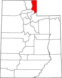
Box Elder County is a county at the northwestern corner of Utah, United States. As of 2018, the estimated population is 54,950. Its county seat and largest city is Brigham City. The county was named for the box elder trees that abound in the county.

Emery County is a county in east-central Utah, United States. As of the 2010 United States Census, the population was 10,976. Its county seat is Castle Dale, and the largest city is Huntington.

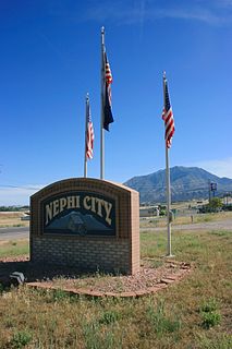
Juab County is a county in western Utah, United States. As of the 2010 United States Census, the population was 10,246. Its county seat and largest city is Nephi.
Piute County is a county in south-central Utah, United States. As of the 2010 United States Census, the population was 1,556, making it the second-least populous county in Utah. The county seat is Junction, and the largest town is Circleville.
Rich County is a county in the U.S. state of Utah. As of the 2010 United States Census, the population was 2,264, making it the third-least populous county in Utah. Its county seat is Randolph, and the largest town is Garden City. The county was created in 1864. It was named for an early LDS apostle, Charles C. Rich.
Washington County is a county in the southwestern corner of Utah, United States. As of the 2020 United States Census, the population was 180,279, making it the fifth-most populous county in Utah. Its county seat and largest city is St. George. The county was created in 1852 and organized in 1856. It was named after the first President of the United States, George Washington. A portion of the Paiute Indian Reservation is in western Washington County. Washington County comprises the St. George, UT Metropolitan Statistical Area.

Brigham City is a city in Box Elder County, Utah, United States. The population was 17,899 at the 2010 census. It is the county seat of Box Elder County. It lies on the western slope of the Wellsville Mountains, a branch of the Wasatch Range at the western terminus of Box Elder Canyon. Brigham City saw most of its growth during the 1950s and 1960s, but has seen a struggling economy and stagnating growth since then. It is near the headquarters of ATK Thiokol, the company that created the solid rocket boosters for the Space Shuttle.

Howell is a town located in the Blue Creek Valley in northeast Box Elder County, Utah, United States. The population was 245 at the 2010 census.
Tremonton is a city in Box Elder County, Utah. The population was 7,647 at the time of the 2010 census.
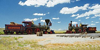
Golden Spike National Historical Park is a United States National Historical Park located at Promontory Summit, north of the Great Salt Lake in east-central Box Elder County, Utah, United States. The nearest city is Corinne, approximately 23 miles (37 km) east-southeast of the site.

Cache Valley is a valley of northern Utah and southeast Idaho, United States, that includes the Logan metropolitan area. The valley was used by 19th century mountain men and was the site of the 1863 Bear River Massacre. The name, Cache Valley is often used synonymously to describe the Logan Metropolitan Area, one of the fastest growing metro areas in the US per capita — both in terms of economic GDP and population.

Interstate 84 (I-84) is a part of the Interstate Highway System that links Portland, Oregon, to I-80 near Echo, Utah. The 117.38-mile-long (188.90 km) segment in the US state of Utah is the shortest of any of the three states the western I-84 passes through and contains the eastern terminus of the highway. I-84 enters Box Elder County near Snowville before becoming concurrent with I-15 in Tremonton. The concurrent highways travel south through Brigham City and Ogden and separate near Ogden-Hinckley Airport. Turing east along the Davis County border, I-84 intersects US Route 89 (US-89) and enters Weber Canyon as well as Morgan County. While in Morgan County, I-84 passes the Devil's Gate-Weber Hydroelectric Power Plant and Devil's Slide rock formation. Past Morgan, the highway crosses into Summit County, past the Thousand Mile Tree before reaching its eastern terminus at I-80 near Echo.

State Route 42 (SR-42) is a 7.390-mile-long (11.893 km) state highway completely within Box Elder County in the U.S. state of Utah. It connects SR-30 to former SH-81 at the Idaho state line. The highway was formerly part of U.S. Route 30S (US-30S), prior to being bypassed and replaced with what is now signed as Interstate 84 (I-84).

Park Valley is an unincorporated community in north-central Box Elder County, Utah, United States.
Standrod is an unincorporated community in extreme northwestern Box Elder County, Utah, United States, very close to the state line with Idaho. Standrod is a rural community that is reached primarily by dirt roads. The residents of Standrod primarily rely on agriculture. The community is in the area of the Raft River Mountains. The climate of the area has four distinct seasons that occur in the northern Great Basin area.
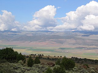
Grouse Creek is an unincorporated community in the nearly unpopulated northwestern region of Box Elder County, Utah, United States, near the Idaho and Nevada borders. The community lies along unpaved roads north of State Route 30 in the Grouse Creek Mountains. Its elevation is 5,331 feet (1,625 m). It has a post office with the ZIP code 84313.
Utah State Route 3 may refer to:

Quail Creek State Park is a state park of Utah, United States, featuring a 600-acre (240 ha) reservoir. The park is located within Hurricane, Utah, 9 miles (14 km) west of the city center and 1.5 miles (2.4 km) south of the historic ghost town of Harrisburg. Quail Creek State Park offers camping, boating, swimming, and fishing.
Cedar Creek is a ghost town in Box Elder County, Utah, United States. Founded in the 1860s, Cedar Creek was a farming town. Businesses included a school, an inn, and a store. The interstate highway system built through Cedar Creek and the nearby communities of Snowville and Park Valley. Cedar Creek was abandoned when weather conditions made farming difficult.
The Juab Valley is a 40-mile (64 km) long valley located on the eastern edge of Juab County, Utah, United States.


