Howell, Utah

Last updated

Howell
Howell Utah School.jpeg
The old schoolhouse in Howell, March 2009
Box Elder County Utah incorporated and unincorporated areas Howell highlighted.svg
Location of Howell within Box Elder County and the State of Utah.
Map of USA UT.svg
Location of Utah in the United States
Coordinates: 41°46′23″N112°27′35″W / 41.77306°N 112.45972°W / 41.77306; -112.45972
Country United States
State Utah
County Box Elder
Settled1910
Incorporated 1941
Named for Joseph Howell [1] :194
Area
[2]
  Total35.47 sq mi (91.87 km2)
  Land35.27 sq mi (91.36 km2)
  Water0.20 sq mi (0.51 km2)
Elevation
[3]
4,561 ft (1,390 m)
Population
 (2010)
  Total245
  Estimate 
(2019) [4]
254
  Density7.20/sq mi (2.78/km2)
Time zone UTC-7 (Mountain (MST))
  Summer (DST) UTC-6 (MDT)
ZIP code
84316
Area code 435
FIPS code 49-36620 [5]
GNIS feature ID1437591 [3]

Howell is a town located in the Blue Creek Valley in northeast Box Elder County, Utah, United States. [3] [1] The population was 245 at the 2010 census.

Contents

Geography

According to the United States Census Bureau, the town has a total area of 35.6 square miles (92 km2), of which 35.4 square miles (92 km2) is land and 0.2 square miles (0.52 km2) (0.56%) is water.

Climate

There is a weather station nearby at Thiokol Airport. Thiokol Airport/Howell's climate borders between being semi-arid and humid continental climate (Köppen BSk/Dfb), characterized by cold winters, warm-to-hot summers, and high diurnal temperature variation throughout the year.

Climate data for Thiokol Propulsion F S, Utah, 1991–2020 normals, 1962-2020 extremes: 4600ft (1402m)
MonthJanFebMarAprMayJunJulAugSepOctNovDecYear
Record high °F (°C)56
(13)
65
(18)
74
(23)
85
(29)
96
(36)
103
(39)
108
(42)
107
(42)
98
(37)
88
(31)
78
(26)
60
(16)
108
(42)
Mean maximum °F (°C)44.6
(7.0)
53.5
(11.9)
67.0
(19.4)
77.5
(25.3)
85.5
(29.7)
95.4
(35.2)
100.9
(38.3)
99.6
(37.6)
93.4
(34.1)
81.1
(27.3)
61.5
(16.4)
48.2
(9.0)
101.9
(38.8)
Average high °F (°C)29.8
(−1.2)
36.7
(2.6)
48.4
(9.1)
56.0
(13.3)
66.8
(19.3)
81.1
(27.3)
89.6
(32.0)
89.1
(31.7)
77.0
(25.0)
60.4
(15.8)
44.4
(6.9)
34.3
(1.3)
59.5
(15.3)
Daily mean °F (°C)21.2
(−6.0)
24.9
(−3.9)
36.1
(2.3)
43.1
(6.2)
53.1
(11.7)
64.1
(17.8)
71.9
(22.2)
70.8
(21.6)
59.5
(15.3)
44.7
(7.1)
32.8
(0.4)
23.1
(−4.9)
45.4
(7.5)
Average low °F (°C)12.5
(−10.8)
13.2
(−10.4)
23.7
(−4.6)
30.1
(−1.1)
39.3
(4.1)
47.0
(8.3)
54.2
(12.3)
52.4
(11.3)
42.0
(5.6)
28.9
(−1.7)
21.2
(−6.0)
12.0
(−11.1)
31.4
(−0.3)
Mean minimum °F (°C)−1.7
(−18.7)
−0.5
(−18.1)
11.0
(−11.7)
20.3
(−6.5)
26.9
(−2.8)
35.3
(1.8)
45.2
(7.3)
42.6
(5.9)
30.1
(−1.1)
18.0
(−7.8)
6.3
(−14.3)
−2.8
(−19.3)
−8.1
(−22.3)
Record low °F (°C)−28
(−33)
−29
(−34)
−5
(−21)
10
(−12)
15
(−9)
29
(−2)
35
(2)
30
(−1)
20
(−7)
10
(−12)
−17
(−27)
−27
(−33)
−29
(−34)
Average precipitation inches (mm)1.42
(36)
0.98
(25)
1.24
(31)
1.12
(28)
1.84
(47)
1.09
(28)
0.60
(15)
0.82
(21)
0.98
(25)
1.13
(29)
0.72
(18)
1.47
(37)
13.41
(340)
Average snowfall inches (cm)5.2
(13)
4.5
(11)
0.7
(1.8)
0.2
(0.51)
0.0
(0.0)
0.0
(0.0)
0.0
(0.0)
0.0
(0.0)
0.0
(0.0)
0.1
(0.25)
2.6
(6.6)
7.0
(18)
20.3
(51.16)
Source 1: NOAA [6]
Source 2: XMACIS2 (1982-2010 snowfall, records & monthly max/mins) [7]

Demographics

Historical population
CensusPop.Note
1920 302
1930 246−18.5%
1940 28114.2%
1950 176−37.4%
1960 1886.8%
1970 146−22.3%
1980 17620.5%
1990 23734.7%
2000 221−6.8%
2010 24510.9%
2019 (est.)254 [4] 3.7%
U.S. Decennial Census [8]

As of the census [5] of 2000, there were 221 people, 68 households, and 55 families residing in the town. The population density was 6.2 people per square mile (2.4/km2). There were 75 housing units at an average density of 2.1 per square mile (0.8/km2). The racial makeup of the town was 99.10% White, 0.45% African American and 0.45% Native American.

There were 68 households, out of which 41.2% had children under the age of 18 living with them, 75.0% were married couples living together, 4.4% had a female householder with no husband present, and 19.1% were non-families. 19.1% of all households were made up of individuals, and 4.4% had someone living alone who was 65 years of age or older. The average household size was 3.25 and the average family size was 3.76.

In the town, the population was spread out, with 36.2% under the age of 18, 12.2% from 18 to 24, 20.8% from 25 to 44, 22.6% from 45 to 64, and 8.1% who were 65 years of age or older. The median age was 26 years. For every 100 females, there were 130.2 males. For every 100 females age 18 and over, there were 101.4 males.

The median income for a household in the town was $40,750, and the median income for a family was $42,250. Males had a median income of $39,861 versus $12,292 for females. The per capita income for the town was $16,510. About 7.3% of families and 7.6% of the population were below the poverty line, including 12.6% of those under the age of eighteen and 17.6% of those 65 or over.

History

Howell lies in the Blue Creek Valley that stretches north-south between four mountain ranges, Promontory Mountains, south, North Promontory Mountains, west, West Hills, northeast, and Blue Spring Hills, southeast. The northeast Great Salt Lake lies to the south of Howell, and north of Howell finds Interstate 84, roughly the area known to locals as Blue Creek. Nomadic Shoshone Indians used the area to travel between the Great Salt Lake and areas to the north.

Charles Crocker, a California developer and business man oversaw development of the First transcontinental railroad, which passed through Promontory, about 10 miles (16 km) south of Howell. The Golden Spike was driven near Promontory (at Lampo) in 1869. Crocker formed the Promontory Land and Livestock Company in this time period, which had land holdings that stretched from the Great Salt Lake north to Idaho, and west to Nevada. The area was used for cattle ranching, with headquarters in Promontory, Howell, and the Dilly Ranch. The company disbanded in 1909.

In 1909 the newly created Promontory-Curlew Land Company purchased the Promontory Land and Livestock Company's Utah and Idaho land holdings. Howell is named after Utah Congressman Joseph Howell who was involved with the Promontory-Curlew Land Company.

In 1910 Nephi Nessen purchased 1,000 acres (4.0 km2) from the Promontory-Curlew Land Company, and established the first private and permanent residence in Howell. Nessen was born in Logan, Utah in 1867, the son of Danish immigrants and converts to the Church of Jesus Christ of Latter-day Saints who crossed the plains from the east as part of a Handcart company. Other settler families included Andersen, Baxter, Cravens, Gunnell, Bailey, Carlsen, Douglas, Fonnesbeck, Rock, Wood, Allen, Barber, and Maughn.

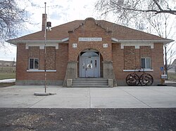
The Bar M Ranch was headquartered near what is now the town center. A school was opened in 1910 in a Bar M Ranch building. In 1911, a new school was opened (pictured above), which has now been converted into a community center. In 1980, a modern school was built for kindergarten through third grades, but closed in 2008.

In 1904, the Blue Creek Reservoir was built on Blue Creek, 1 mile (1.6 km) northwest of Howell. [9] However, the reservoir is now located almost entirely within the town limits [10]

Transportation

While I-84 only passes through the northeastern corner of the town, SR-83 heads south from the interstate to pass through the town (and continues on to Corinne). [10]

See also

Related Research Articles

<span class="mw-page-title-main">Box Elder County, Utah</span> County in Utah, United States

Box Elder County is a county at the northwestern corner of Utah, United States. At the 2020 census, the population was 57,666, up from the 2010 figure of 49,975. Its county seat and largest city is Brigham City. The county was named for the box elder trees that abound in the county.

<span class="mw-page-title-main">Duchesne County, Utah</span> County in Utah, United States

Duchesne County is a county in the northeast part of the U.S. state of Utah. As of the 2020 United States Census, the population was 19,596. Its county seat is Duchesne, and the largest city is Roosevelt.

<span class="mw-page-title-main">Juab County, Utah</span> County in Utah, United States

Juab County is a county in western Utah, United States. As of the 2020 United States Census, the population was 11,786. Its county seat and largest city is Nephi.

<span class="mw-page-title-main">Piute County, Utah</span> County in Utah, United States

Piute County is a county in south-central Utah, United States. As of the 2020 United States Census, the population was 1,438, making it the second-least populous county in Utah. The county seat is Junction, and the largest town is Circleville.

<span class="mw-page-title-main">Morgan County, Utah</span> County in Utah, United States

Morgan County is a county in northern Utah, United States. As of the 2020 census, the population was 12,295. Its county seat and largest city is Morgan. Morgan County is part of the Ogden-Clearfield, UT Metropolitan Statistical Area as well as the Salt Lake City-Provo-Orem, UT Combined Statistical Area.

<span class="mw-page-title-main">Corinne, Utah</span> City in Utah, United States

Corinne is a city in Box Elder County, Utah, United States. The population was 809 at the 2020 census, up from the 2010 figure of 685.

<span class="mw-page-title-main">Fielding, Utah</span> Town in Utah, United States

Fielding is a town in Box Elder County, Utah, United States. The population was 455 at the 2010 census.

<span class="mw-page-title-main">Mantua, Utah</span> Town in the state of Utah, United States

Mantua is a town on the eastern edge Box Elder County, Utah, United States. The population of the town was 687 at the 2010 census.

<span class="mw-page-title-main">Riverside, Utah</span> CDP in Utah, United States

Riverside is a census-designated place (CDP) in Box Elder County, Utah, United States. The population was 760 at the 2010 census.

<span class="mw-page-title-main">Snowville, Utah</span> Town in the state of Utah, United States

Snowville is a town in Box Elder County, Utah, United States. The population was 167 at the 2010 census.

<span class="mw-page-title-main">Amalga, Utah</span> Town in the state of Utah, United States

Amalga is a town in Cache County, Utah, United States. The population was 488 at the 2010 census. It is included in the Logan, Utah-Idaho (partial) Metropolitan Statistical Area.

<span class="mw-page-title-main">Antimony, Utah</span> Town in the state of Utah, United States

Antimony is a town in Garfield County, Utah, United States. The population was 122 at the 2010 census, the same as the 2000 census.

<span class="mw-page-title-main">Paragonah, Utah</span> Town in the state of Utah, United States

Paragonah is a town in Iron County, Utah, United States. The population was 488 at the 2010 census.

<span class="mw-page-title-main">Levan, Utah</span> Town in Juab County, Utah, United States

Levan is a town in Juab County, Utah, United States. As of the 2020 census it had a population of 862.

<span class="mw-page-title-main">Rocky Ridge, Utah</span> Town in the state of Utah, United States

Rocky Ridge is a town on the northeastern edge of Juab County, Utah, United States. As of the 2010 census it had a population of 733, and in 2018 the estimated population was 833.

<span class="mw-page-title-main">Aurora, Utah</span> City in Utah, United States

Aurora is a city in north-central Sevier County, Utah, United States. The population was 923 in the 2020 Census.

<span class="mw-page-title-main">Joseph, Utah</span> Town in the state of Utah, United States

Joseph is a town in Sevier County, Utah, United States. The population was 269 at the 2000 census. The town was named for Joseph Angell Young, an apostle of the Church of Jesus Christ of Latter-day Saints. Joseph was settled in 1871.

<span class="mw-page-title-main">Coalville, Utah</span> City in the United States

Coalville is a city in and the county seat of Summit County, Utah, United States. It is part of the Salt Lake City, Utah Metropolitan Statistical Area. The population was 1,486 as of the 2020 census. Interstate 80 passes through the town, as well as the Weber River, which flows into Echo Reservoir, just north of Coalville.

<span class="mw-page-title-main">Vernon, Utah</span> Town in the state of Utah, United States

Vernon is a town in southeastern Tooele County, Utah, United States.

Blue Creek is a ghost town in the Blue Creek Valley in northeastern Box Elder County, Utah, United States.

References

  1. 1 2 Van Cott, John W. (1990). Utah Place Names: A Comprehensive Guide to the Origins of Geographic Names: A Compilation. Salt Lake City: University of Utah Press. p. 194. ISBN   978-0-87480-345-7. OCLC   797284427.
  2. "2019 U.S. Gazetteer Files". United States Census Bureau. Retrieved August 7, 2020.
  3. 1 2 3 U.S. Geological Survey Geographic Names Information System: Howell, Utah
  4. 1 2 "Population and Housing Unit Estimates". United States Census Bureau. May 24, 2020. Retrieved May 27, 2020.
  5. 1 2 "U.S. Census website". census.gov. United States Census Bureau . Retrieved January 31, 2008.
  6. "Thiokol Propulsion F S, Utah 1991-2020 Monthly Normals" . Retrieved November 19, 2023.
  7. "xmACIS". National Oceanic and Atmospheric Administration. Retrieved November 19, 2023.
  8. "Census of Population and Housing". census.gov. Retrieved June 4, 2015.
  9. Van Cott, John W. (1990). Utah Place Names: A Comprehensive Guide to the Origins of Geographic Names: A Compilation. Salt Lake City: University of Utah Press. p. 41. ISBN   978-0-87480-345-7. OCLC   797284427 . Retrieved March 20, 2018.
  10. 1 2 Google (December 26, 2016). "Howell, Utah 84316" (Map). Google Maps . Google. Retrieved December 26, 2016.