Perry, Utah

Last updated
Perry, Utah
Heritage Theatre Perry Utah.jpeg
The Heritage Community Theatre, a Perry landmark
Motto(s): 
"Building a Community Together"
Box Elder County Utah incorporated and unincorporated areas Perry highlighted.svg
Location in Box Elder County and the state of Utah
Map of USA UT.svg
Location of Utah in the United States
Coordinates: 41°27′43″N112°2′12″W / 41.46194°N 112.03667°W / 41.46194; -112.03667 Coordinates: 41°27′43″N112°2′12″W / 41.46194°N 112.03667°W / 41.46194; -112.03667
Country United States
State Utah
County Box Elder
Settled1853
Named for Gustavus Adolphus Perry
Area
[1]
  Total8.00 sq mi (20.72 km2)
  Land8.00 sq mi (20.72 km2)
  Water0.00 sq mi (0.01 km2)
Elevation
[2]
4,367 ft (1,331 m)
Population
 (2010)
  Total4,512
  Estimate 
(2019) [3]
5,248
  Density656.08/sq mi (253.32/km2)
Time zone UTC-7 (Mountain (MST))
  Summer (DST) UTC-6 (MDT)
ZIP code
84302
Area code(s) 435
FIPS code 49-59390 [4]
GNIS feature ID1455150 [2]
Website www.perrycity.org

Perry is a city in Box Elder County, Utah, United States. The population was 4,512 at the 2010 census. [5]

Contents

History

Land in the area now known as Perry was first claimed in 1851 by Orrin Porter Rockwell and his brother Merritt, at a place now called Porter Spring. However, they only laid claim to the land and did not build a residence. Settlement by LDS pioneers began in 1853, when William Plummer Tippets built a cabin at the settlement known as "Three Mile Creek", there being a creek three miles south of Box Elder (now Brigham City). Another settlement known as "Welsh Settlement" was midway between Three Mile Creek and Box Elder, which joined with Three Mile Creek in 1869. In 1898 the community was renamed Perry after Gustavus Adolphus Perry and his family, who were among the early settlers. [6]

In 1854 Gustavus Adolphus Perry was made LDS branch president at the location. It had various branch presidents from then until 1877. In 1877 it was made a ward with Orrin Alonzo Perry as bishop. [7] In 1930 there were 341 inhabitants in Perry. It still only had enough Latter-day Saints for one ward. In the spring of 2008 the Perry Utah Stake was created by a division of the Willard Utah Stake. This stake consists of nine wards, but one of the wards in the Willard Stake is a Perry Ward as well. [8]

In June 1896 a partially completed reservoir at the mouth of Three Mile Creek Canyon (now Perry Canyon) overflowed, flooding much of the town, destroying homes and covering farms with mud and gravel. A second flood in 1923 caused less damage. [9]

Geography

Looking east from I-15 toward Perry, Utah and the Wasatch Mountains, October 2014 Utah (16217331845).jpg
Looking east from I-15 toward Perry, Utah and the Wasatch Mountains, October 2014

Perry is located in southeastern Box Elder County and is bordered by Brigham City to the north and Willard to the south. The east side of the city is bordered by Cache National Forest at the northern end of the Wasatch Range.

Interstate Highways 15 and 84 run through the western side of the city, with access south of the city from Exit 357 in Willard and north of the city from Exit 362 through Brigham City. U.S. Route 89 runs through the center of the city.

The city has historically been primarily rural and agricultural, consisting of family dairies, cattle farms, and fruit orchards, with many fruit stands along U.S. 89 through Box Elder County to southern Idaho known as Utah's Fruit Belt. [10] It is now primarily a suburban residential community, [9] with some commercial activity along the northern border with Brigham City and along U.S. 89.

According to the United States Census Bureau, the city has a total area of 8.0 square miles (20.8 km2), all land. [5]

Demographics

Historical population
CensusPop.
1900 260
1910 29212.3%
1920 36725.7%
1930 341−7.1%
1940 38312.3%
1950 44917.2%
1960 58730.7%
1970 90954.9%
1980 1,08419.3%
1990 1,21111.7%
2000 2,38396.8%
2010 4,51289.3%
2019 (est.)5,248 [3] 16.3%
U.S. Decennial Census [11]

As of the census of 2010, [5] there were 4,512 people, 1,373 households, and 1,179 families residing in the city. The population density was 564 people per square mile (216.9/km2). There were 1,427 housing units at an average density of 178.4 per square mile (68.6/km2). The racial makeup of the city was 94.5% White, 0.1% African American, 0.7% Native American, 0.7% Asian, 0.3% Pacific Islander, 1.8% from other races, and 1.8% from two or more races. Hispanic or Latino of any race were 4.6% of the population.

There were 1,373 households, out of which 46.5% had children under the age of 18 living with them, 76.3% were married couples living together, 6.9% had a female householder with no husband present, and 14.1% were non-families. 12.0% of all households were made up of individuals, and 5.3% had someone living alone who was 65 years of age or older. The average household size was 3.29 and the average family size was 3.60.

In the city, the population was spread out, with 36.1% under the age of 18, 6.5% from 18 to 24, 27.2% from 25 to 44, 19.1% from 45 to 64, and 11.1% who were 65 years of age or older. The median age was 31.1 years. For every 100 females, there were 101 males. For every 100 females age 18 and over, there were 99.4 males.

During the census of 2000, [4] the median income for a household in the city was $52,500, and the median income for a family was $57,857. Males had a median income of $41,761 versus $26,806 for females. The per capita income for the city was $19,092. About 1.2% of families and 2.2% of the population were below the poverty line, including 2.9% of those under age 18 and 4.0% of those age 65 or over.

Education

Perry is part of the Box Elder School District. The city has one public, and one public charter, elementary school. Students attend schools in Willard and Brigham City for other grades.

Recreation

The city has four parks, one with a baseball diamond and room for soccer, one with two soccer fields, and one a nature park. [12] Trails for hiking lead up the canyons into Cache National Forest, and connect with the Bonneville Shoreline Trail.

See also

Related Research Articles

Box Elder County, Utah U.S. county in Utah

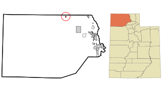
Box Elder County is a county at the northwestern corner of Utah, United States. As of 2018, the estimated population is 54,950. Its county seat and largest city is Brigham City. The county was named for the box elder trees that abound in the county.

Weber County, Utah U.S. county in Utah

Weber County is a county in the U.S. state of Utah. As of the 2010 census, the population was 231,236, making it Utah's fourth-most populous county. Its county seat and largest city is Ogden, the home of Weber State University. The county was named for the Weber River.

Preston, Idaho City in Idaho, United States

Preston is a city in Franklin County, Idaho, United States. The population was 5,204 at the 2010 census. The city is the county seat of Franklin County. It is part of the Logan, Utah-Idaho Metropolitan Statistical Area.

Bear River City, Utah City in Utah, United States

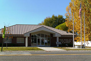
Bear River City is a city in Box Elder County, Utah, United States. The population was 853 at the 2010 census, an increase over the 2000 population of 750. The population was sufficient under Utah state law for Bear River to become a city near the end of 2000. Although current state law requires a minimum population of 1000 for cities, Bear River City remains a city.

Brigham City, Utah City in Utah, United States

Brigham City is a city in Box Elder County, Utah, United States. The population was 17,899 at the 2010 census. It is the county seat of Box Elder County. It lies on the western slope of the Wellsville Mountains, a branch of the Wasatch Range at the western terminus of Box Elder Canyon. Brigham City saw most of its growth during the 1950s and 1960s, but has seen a struggling economy and stagnating growth since then. It is near the headquarters of ATK Thiokol, the company that created the solid rocket boosters for the Space Shuttle.
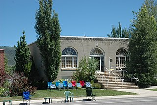
Corinne, Utah Town in Utah, United States

Corinne is a town in Box Elder County, Utah, United States. The population was 685 at the 2010 census.

Garland, Utah City in Utah, United States

Garland is a city in northeastern Box Elder County, Utah, United States. The population was 2,400 at the 2010 census.

Honeyville, Utah City in Utah, United States

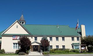
Honeyville is a city near the eastern edge of Box Elder County, Utah, United States. The population was 1,441 at the 2010 census.

Howell, Utah Town in Utah, United States

Howell is a town located in the Blue Creek Valley in northeast Box Elder County, Utah, United States. The population was 245 at the 2010 census.

Mantua, Utah Town in Utah, United States

Mantua is a town on the eastern edge Box Elder County, Utah, United States. The population of the town was 687 at the 2010 census.

Snowville, Utah Town in Utah, United States

Snowville is a town in Box Elder County, Utah, United States. The population was 167 at the 2010 census.

South Willard, Utah CDP in Utah, United States

South Willard is a census-designated place (CDP) in Box Elder County, Utah, United States. The population was 1,571 at the 2010 census.

Willard, Utah City in Utah, United States

Willard is a city in Box Elder County, Utah, United States. The population was 1,772 at the 2010 census.

Providence, Utah City in Utah, United States

Providence is a city in Cache County, Utah, United States. The population was 7,075 at the 2010 census. It is included in the Logan, Utah-Idaho Metropolitan Statistical Area.

Smithfield, Utah City in Utah, United States

Smithfield is a city in Cache County, Utah, United States. The population was 9,495 at the 2010 census, with an estimated population of 12,025 in 2019. It is included in the Logan, Utah-Idaho Metropolitan Statistical Area, and is the second largest city in the area after Logan, the county seat. Smithfield is home to Sky View High School.

Kaysville, Utah City in Utah, United States

Kaysville is a city in Davis County, Utah. It is part of the Ogden–Clearfield metropolitan area. The population was 27,300 at the time of the 2010 census, with an estimated population of 32,390 in 2019.

Oakley, Utah City in Utah, United States

Oakley is a city in Summit County, Utah, United States. It is part of the Salt Lake City, Utah Metropolitan Statistical Area. The population was 1,470 at the 2010 census.

Mapleton, Utah City in Utah, United States

Mapleton is a city in Utah County, Utah, United States. It is part of the Provo–Orem Metropolitan Statistical Area. The population was 7,979 at the 2010 census.

Pleasant Grove, Utah City in Utah, United States

Pleasant Grove, originally named Battle Creek, is a city in Utah County, Utah, United States known as "Utah's City of Trees". It is part of the Provo–Orem Metropolitan Statistical Area. The population was 33,509 at the 2010 Census.

West Haven, Utah City in Utah, United States

West Haven is a city in Weber County, Utah, United States. The population was 10,272 at the 2010 census. It was incorporated on July 1, 1991, combining the unincorporated communities of Kanesville and Wilson.

References

  1. "2019 U.S. Gazetteer Files". United States Census Bureau. Retrieved August 7, 2020.
  2. 1 2 U.S. Geological Survey Geographic Names Information System: Perry
  3. 1 2 "Population and Housing Unit Estimates". United States Census Bureau. May 24, 2020. Retrieved May 27, 2020.
  4. 1 2 "U.S. Census website". United States Census Bureau . Retrieved 2008-01-31.
  5. 1 2 3 "Geographic Identifiers: 2010 Demographic Profile Data (G001): Perry city, Utah". U.S. Census Bureau, American Factfinder. Archived from the original on February 12, 2020. Retrieved July 11, 2015.
  6. Lee Perry, "Elder L. Tom Perry of the Council of the Twelve", Ensign , February 1975, p. 9.
  7. Andrew Jenson. Encyclopedic History of the Church . vol. ? p. 651.
  8. Perry Stake website homepage
  9. 1 2 Perry History, Box Elder County website
  10. Jeff Vice, Fruit Stands Going Strong Despite I-15, Deseret News, May 17, 1993
  11. "Census of Population and Housing". Census.gov. Retrieved June 4, 2015.
  12. Perry City Parks