Wellsville, Utah

Last updated

Wellsville, Utah
Wellsville Tabernacle of the LDS Church.jpg
The Wellsville Tabernacle, an early Latter-day Saint meetinghouse
Cache County Utah incorporated and unincorporated areas Wellsville highlighted.svg
Location in Cache County and the state of Utah
Coordinates: 41°38′8″N111°55′59″W / 41.63556°N 111.93306°W / 41.63556; -111.93306
Country United States
State Utah
County Cache
Founded (as Maughan's Fort)1856
Named for Daniel H. Wells
Area
[1]
  Total7.28 sq mi (18.86 km2)
  Land7.27 sq mi (18.83 km2)
  Water0.01 sq mi (0.04 km2)
Elevation
[2]
4,547 ft (1,386 m)
Population
 (2010)
  Total3,432
  Estimate 
(2019) [3]
3,941
  Density542.17/sq mi (209.32/km2)
Time zone UTC-7 (Mountain (MST))
  Summer (DST) UTC-6 (MDT)
ZIP code
84339
Area code 435
FIPS code 49-82620 [4]
GNIS feature ID1447103 [2]
Website www.wellsvillecity.com

Wellsville is a city in Cache County, Utah, United States. The population was 4,060 at the 2020 census. [5] Wellsville is located at the base of the Wellsville mountain range. It is included in the Logan, Utah-Idaho Metropolitan Statistical Area.

Contents

Wellsville is home to the Utah State University South Farm as well as the Utah State University Equestrian Center, the American Heritage Center and the Wellsville Tabernacle.

Wellsville was laid out in 1856, and named after Daniel H. Wells, a Mormon leader. [6]

Geography

Wellsville is on the Eastern side of the Wellsville Mountains. According to the United States Census Bureau, the city has a total area of 6.6 square miles (17.1 km2), of which 0.02 square miles (0.04 km2), or 0.21%, is water. [7]

Climate

Large seasonal temperature differences typify this climatic region, with warm to hot (and often humid) summers and cold (sometimes severely cold) winters. According to the Köppen Climate Classification system, Wellsville has a humid continental climate, abbreviated "Dfb" on climate maps. [8]

Demographics

Historical population
CensusPop.Note
1870 885
1880 1,19334.8%
1890 1,045−12.4%
1900 908−13.1%
1910 1,19531.6%
1920 1,2988.6%
1930 1,270−2.2%
1940 1,40210.4%
1950 1,241−11.5%
1960 1,106−10.9%
1970 1,26714.6%
1980 1,95254.1%
1990 2,20613.0%
2000 2,72923.7%
2010 3,43225.8%
2019 (est.)3,941 [3] 14.8%
U.S. Decennial Census [9]

As of the census [4] of 2000, there were 2,729 people, 778 households, and 686 families residing in the city. The population density was 429.3 inhabitants per square mile (165.8/km2). There were 815 housing units at an average density of 128.2 per square mile (49.5/km2). The racial makeup of the city was 97.29% White, 0.40% Native American, 0.15% Asian, 0.15% Pacific Islander, 1.73% from other races, and 0.29% from two or more races. Hispanic or Latino of any race were 2.79% of the population.

There were 778 households, out of which 55.3% had children under 18 living with them, 79.8% were married couples living together, 5.4% had a female householder with no husband present, and 11.8% were non-families. 9.8% of all households were made up of individuals, and 5.7% had someone living alone who was 65 years of age or older. The average household size was 3.51, and the average family size was 3.79.

The city's population was spread out, with 38.3% under 18, 10.2% from 18 to 24, 26.9% from 25 to 44, 16.9% from 45 to 64, and 7.7% who were 65 years of age or older. The median age was 26 years. For every 100 females, there were 104.0 males. For every 100 females aged 18 and over, there were 101.4 males.

The median income for a household in the city was $49,115, and the median income for a family was $51,023. Males had a median income of $37,244 versus $21,750 for females. The per capita income for the city was $16,171. About 5.8% of families and 6.4% of the population were below the poverty line, including 8.1% of those under age 18 and 8.8% of those aged 65 or over.

Notable person

Related Research Articles

<span class="mw-page-title-main">McCammon, Idaho</span> City in Idaho, United States

McCammon is a city in Bannock County, Idaho, United States. It is part of the Pocatello, Idaho Metropolitan Statistical Area'. The population was 809 at the 2010 census. In 1892, McCammon became the junction point between the Oregon Short Line Railroad and Utah and Northern Railway, and city gained the nickname Junction City.

<span class="mw-page-title-main">Tekamah, Nebraska</span> City in Nebraska, United States

Tekamah is a city in Burt County, Nebraska, United States. The population was 1,736 at the 2010 census. It is the county seat of Burt County.

<span class="mw-page-title-main">New Rockford, North Dakota</span> City in North Dakota, United States

New Rockford is a city in Eddy County, North Dakota, United States. It is the county seat of Eddy County. The population was 1,361 at the 2020 census. New Rockford was founded in 1883.

<span class="mw-page-title-main">Underwood, North Dakota</span> City in North Dakota, United States

Underwood is a city in McLean County, North Dakota, United States. The population was 784 at the 2020 census.

<span class="mw-page-title-main">Coal Center, Pennsylvania</span> Borough in Pennsylvania, United States

Coal Center is a borough on the Monongahela River in Washington County, Pennsylvania, United States and part of the Pittsburgh metropolitan area since 1950. The population was 110 at the 2020 census.

<span class="mw-page-title-main">Parkston, South Dakota</span> City in South Dakota, United States

Parkston is a city in Hutchinson County, South Dakota, United States. The population was 1,567 at the 2020 census.

<span class="mw-page-title-main">Lewiston, Utah</span> City in Utah, United States

Lewiston is a city in Cache County, Utah, United States. It is situated at the northern Utah border and borders the state of Idaho. The population was 1,766 at the 2010 census. It is included in the Logan, Utah-Idaho (partial) Metropolitan Statistical Area.

<span class="mw-page-title-main">Trenton, Utah</span> Town in Utah, United States

Trenton is a town in Cache County, Utah, United States. The population was 464 at the 2010 census. It is included in the Logan, Utah-Idaho (partial) Metropolitan Statistical Area.

<span class="mw-page-title-main">Wellington, Utah</span> City in Utah, United States

Wellington is a city in Carbon County, Utah, United States. The population was 1,676 at the 2010 census. The community was settled in 1878 by a band of thirteen Mormons led by Jefferson Tidwell. The town was named for Justus Wellington Seeley, Jr., of the Emery County Court. Many residents commute to nearby Price for their jobs, or work in one of the various coal mines in the area.

<span class="mw-page-title-main">Nephi, Utah</span> City in and county seat of Juab County, Utah, United States

Nephi is a city in Juab County, Utah, United States. It is part of the Provo–Orem metropolitan area. The population was 6,443 at the 2020 census. It is the county seat of Juab County. It was settled by Mormon pioneers in 1851 as Salt Creek, and it acquired its current name in 1882. It is the principal city in the Juab Valley, an agricultural area. Nephi was named after Nephi, son of Lehi, from the Book of Mormon.

<span class="mw-page-title-main">Meadow, Utah</span> Town in the state of Utah, United States

Meadow is a town in Millard County, Utah, United States. The population was 254 at the 2000 census. Originally called Meadow Creek, the town is located about eight miles south of Fillmore.

<span class="mw-page-title-main">Junction, Utah</span> Town in the state of Utah, United States

Junction is a town in and the county seat of Piute County, Utah, United States. The population was 191 at the 2010 census.

<span class="mw-page-title-main">Garden City, Utah</span> Town in the state of Utah, United States

Garden City is a town in northwestern Rich County, Utah, United States. The population was 562 at the 2010 census. Garden City sits on the shores of Bear Lake and is a popular summer resort destination town, thus nicknamed the "Caribbean of the Rockies”.

<span class="mw-page-title-main">Moroni, Utah</span> City in Utah, United States

Moroni is a city in Sanpete County, Utah, United States. The population was 1,423 at the 2010 census.

<span class="mw-page-title-main">Redmond, Utah</span> Town in the state of Utah, United States

Redmond is a town in Sevier County, Utah, United States. The population was 730 at the 2010 census. Redmond was first settled in 1876, and named for red mounds to the west of the town.

<span class="mw-page-title-main">Henefer, Utah</span> Town in Utah, United States

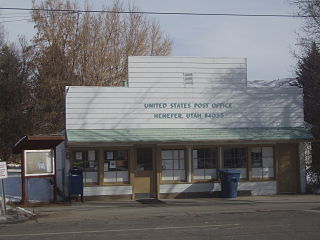
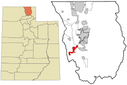
Henefer is a town in Summit County, Utah, United States. It is part of the Salt Lake City, Utah Metropolitan Statistical Area. The population was 766 at the 2010 census.

<span class="mw-page-title-main">Salem, Utah</span> City in Utah, United States

Salem is a city in Utah County, Utah. It is part of the Provo–Orem metropolitan area. The population was 9,298 at the time of the 2020 U.S. census. Landmark locations in Salem include the Dream Mine of John Hyrum Koyle and the Salem Pond.

<span class="mw-page-title-main">Huntsville, Utah</span> Town in the state of Utah, United States

Huntsville is a town in Weber County, Utah, United States. The population was 608 at the 2010 census. It is located in Ogden Valley. It is part of the Ogden–Clearfield, Utah Metropolitan Statistical Area, as well as the Ogden Valley census county division.

<span class="mw-page-title-main">Uintah, Utah</span> City in Utah, United States

Uintah is a city in Weber County, Utah, United States. The population was 1,322 at the 2010 census. It is part of the Ogden–Clearfield, Utah Metropolitan Statistical Area. Although Uintah was a town in 2000, it has since been classified as a fifth-class city by state law.

<span class="mw-page-title-main">Granville, West Virginia</span> Town in West Virginia

Granville is a town in Monongalia County, West Virginia, United States. The population was 1,355 at the 2020 census. It is included in the Morgantown metropolitan area.

References

  1. "2019 U.S. Gazetteer Files". United States Census Bureau. Retrieved August 7, 2020.
  2. 1 2 U.S. Geological Survey Geographic Names Information System: Wellsville
  3. 1 2 "Population and Housing Unit Estimates". United States Census Bureau. May 24, 2020. Retrieved May 27, 2020.
  4. 1 2 "U.S. Census website". United States Census Bureau . Retrieved January 31, 2008.
  5. "USA Today, 2020 Census Data -- Wellsville, Ut" . Retrieved April 14, 2024.
  6. Lund, Anthon Henrik (1922). The Utah Genealogical and Historical Magazine. Geneal. Society of Utah. p. 41.
  7. "USA Today, 2020 Census Data". U.S. Census Bureau, American Factfinder. Retrieved April 14, 2024.
  8. Climate Summary for Wellsville, Utah
  9. "Census of Population and Housing". Census.gov. Retrieved June 4, 2015.