Clarkston, Utah

Last updated

Clarkston, Utah
Martin Harris monument.JPG
Cache County Utah incorporated and unincorporated areas Clarkston highlighted.svg
Location in Cache County and the state of Utah.
Coordinates: 41°55′8″N112°2′58″W / 41.91889°N 112.04944°W / 41.91889; -112.04944
Country United States
State Utah
County Cache
Founded1864
Named for Israel Justus Clark
Area
[1]
  Total0.93 sq mi (2.40 km2)
  Land0.93 sq mi (2.40 km2)
  Water0.00 sq mi (0.00 km2)
Elevation
[2]
4,879 ft (1,487 m)
Population
 (2010)
  Total666
  Estimate 
(2019) [3]
740
  Density797.41/sq mi (307.98/km2)
Time zone UTC-7 (Mountain (MST))
  Summer (DST) UTC-6 (MDT)
ZIP code
84305
Area code 435
FIPS code 49-13190 [4]
GNIS feature ID1426671 [2]

Clarkston is a town in Cache County, Utah, United States. The population was 666 at the 2010 census. It is included in the Logan, Utah-Idaho Metropolitan Statistical Area. The community celebration is held in June each year and is known as The Pony Express Days. [5]

Contents

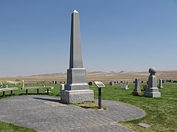
Clarkston is noted for being the last home of Martin Harris, one of the Three Witnesses of the Book of Mormon. He is buried in Clarkston, and every other year a pageant commemorates his life. The pageant was discontinued in 2018. [6] [7]

Many of it residents enjoy the local wildlife which includes mule deer, [8] sharp-tailed grouse, [9] and pheasant. [10]

History

The townsite of Clarkston was laid out in 1864. [11] It was named for Israel Justus Clark, who was an early settler and the first branch president of the Church of Jesus Christ of Latter-day Saints in Clarkston. [12] The settlers originally settled east of modern-day Clarkston in a spot known as the flat. Due to water quality concerns and sickness, they moved the town to a higher elevation and closer to City Creek and other springs. They also experimented in dry farming, mainly north of town. There was trouble with the native Americans, and in 1866 the settlement was abandoned for a short time. Eventually, an agreement was made between the settlers and Indian John, a chief under the Washakie. [13] A Latter-day Saint ward was organized in Clarkston in the fall of 1867 with William F. Rigby as bishop. [14] A brick meetinghouse was built in 1910. [14] In 1930 Clarkston had a population of 570. [14] Among the first settlers were Israel J. Clark, James Myler, William Ricks, Michael Poulsen, Johannis Dahle, Gideon Harmison, David Cook, John Griffiths, John Griffin, John Godfrey, Samuel Whitney, Ole S. Jensen and their families; also the Thompson and Hansen families, A. W. Heggie, a Mr. Parker, Paul Paulson, Andrew McCombs, Simon Smith, Isaac Cook, A. H. Atkinson, and others. [15] The existence of the Clarkston settlement was threatened in 1869 when a majority of the settlers, due mainly to discouragement because of the severe winters and heavy drifting snow, decided to move to the present site of Newton, Utah. But a few people decided to stay in Clarkston, and some who had left returned, and the settlement became a permanent one. There was a controversy over retaining the name Clarkston for the original settlement or transferring it to the "New Town." [16]

Geography

According to the United States Census Bureau, the town has a total area of 1 square mile (2.6 km2), all land. High above Clarkston rises Gunsight Peak, at an elevation of 8244 feet. [17] Clarkston averages 219 sunny days a year. The average rainfall is 18 inches a year, with an average snowfall of 62 inches per year. [18]

Demographics

Historical population
CensusPop.Note
1870 153
1880 464203.3%
1890 440−5.2%
1900 4758.0%
1910 56418.7%
1920 528−6.4%
1930 5708.0%
1940 5791.6%
1950 526−9.2%
1960 490−6.8%
1970 420−14.3%
1980 56233.8%
1990 64514.8%
2000 6886.7%
2010 666−3.2%
2019 (est.)740 [3] 11.1%
U.S. Decennial Census [19]

As of the census [4] of 2000, there were 688 people, 206 households, and 172 families residing in the town. The population density was 718.0 inhabitants per square mile (277.2/km2). There were 219 housing units at an average density of 228.6 per square mile (88.3/km2). The racial makeup of the town was 95.78% White, 0.29% Native American, 1.60% from other races, and 2.33% from two or more races. Hispanic or Latino of any race were 2.18% of the population.

There were 206 households, out of which 47.1% had children under the age of 18 living with them, 76.7% were married couples living together, 4.9% had a female householder with no husband present, and 16.5% were non-families. 16.0% of all households were made up of individuals, and 9.2% had someone living alone who was 65 years of age or older. The average household size was 3.34, and the average family size was 3.78.

In the town, the population was spread out, with 35.5% under 18, 10.9% from 18 to 24, 23.4% from 25 to 44, 19.8% from 45 to 64, and 10.5% who were 65 years of age or older. The median age was 28 years. For every 100 females, there were 108.5 males. For every 100 females aged 18 and over, there were 100.9 males.

The median income for a household in the town was $40,592, and the median income for a family was $42,171. Males had a median income of $32,344 versus $20,000 for females. The per capita income for the town was $13,626. None of the families and 0.7% of the population lived below the poverty line, including no under eighteens and 7.2% of those over 64.

Notable people

Related Research Articles

<span class="mw-page-title-main">Pima, Arizona</span> Town in Graham County, Arizona

Pima is a town in Graham County, Arizona, United States. As of the 2010 census, the population of the town was 2,387, up from 1,989 in 2000. The estimated population in 2018 was 2,512. Pima is part of the Safford Micropolitan Statistical Area.

<span class="mw-page-title-main">Garland, Utah</span> City in Utah, United States

Garland is a city in northeastern Box Elder County, Utah, United States. The population was 2,400 at the 2010 census.

<span class="mw-page-title-main">Perry, Utah</span> City in Utah, United States

Perry is a city in Box Elder County, Utah, United States. The population was 4,512 at the 2010 census.

<span class="mw-page-title-main">Hyde Park, Utah</span> City in Utah, United States

Hyde Park is a city in north-central Cache County, Utah, United States. The population was 3,833 at the 2010 census, with an estimated population of 4,700 in 2018. It is included in the Logan, Utah-Idaho Metropolitan Statistical Area.

<span class="mw-page-title-main">Mendon, Utah</span> City in Utah, United States

Mendon is a city in Cache County, Utah, United States. The population was 1,282 at the 2010 census. It is included in the Logan, Utah-Idaho Metropolitan Statistical Area.

<span class="mw-page-title-main">Newton, Utah</span> Town in the state of Utah, United States

Newton is a town in Cache County, Utah, United States. It was founded in 1869 by pioneers of the Church of Jesus Christ of Latter-day Saints. The population was 789 at the 2010 census. It is included in the Logan, Utah-Idaho Metropolitan Statistical Area.

<span class="mw-page-title-main">Peter, Utah</span> Census-designated place in Utah, United States

Peter is a census-designated place (CDP) on the west-central edge of Cache County, Utah, United States. The population was 324 at the 2010 census. It is included in the Logan, Utah-Idaho (partial) Metropolitan Statistical Area.

<span class="mw-page-title-main">Kaysville, Utah</span> City in Utah, United States

Kaysville is a city in Davis County, Utah. It is part of the Ogden–Clearfield metropolitan area. The population was 27,300 at the time of the 2010 census, with an estimated population of 32,390 in 2019.

<span class="mw-page-title-main">Clawson, Utah</span> Town in the state of Utah, United States

Clawson is a town in Emery County, Utah, United States. The population was 163 at the 2020 census. The community was named after Rudger Clawson, a Mormon leader.

<span class="mw-page-title-main">Glendale, Utah</span> Town in Utah, United States

Glendale is a town in Kane County, Utah, United States. The population was 381 at the 2010 census.

<span class="mw-page-title-main">Holden, Utah</span> Town in the state of Utah, United States

Holden is a town in Millard County, Utah, United States. The population was 378 at the 2010 census.

<span class="mw-page-title-main">Kanosh, Utah</span> Town in the state of Utah, United States

Kanosh is a town in Millard County, Utah, United States. The population was 474 at the 2010 census.

<span class="mw-page-title-main">Leamington, Utah</span> Town in the state of Utah, United States

Leamington is a town in Millard County, Utah. The population was 217 at the time of the 2000 census.

<span class="mw-page-title-main">Circleville, Utah</span> Town in the state of Utah, United States

Circleville is a town in Piute County, Utah, United States. The population was 547 at the 2010 census.

<span class="mw-page-title-main">Manti, Utah</span> City in Utah, United States

Manti is a city in and the county seat of Sanpete County, Utah, United States. The population was 3,276 at the 2010 United States Census.

<span class="mw-page-title-main">Mayfield, Utah</span> Town in the state of Utah, United States

Mayfield is a town in southwestern Sanpete County, Utah, United States. The population was 496 at the 2010 census.

<span class="mw-page-title-main">Joseph, Utah</span> Town in the state of Utah, United States

Joseph is a town in Sevier County, Utah, United States. The population was 269 at the 2000 census. The town was named for Joseph Angell Young, an apostle of the Church of Jesus Christ of Latter-day Saints. Joseph was settled in 1871.

<span class="mw-page-title-main">Salem, Utah</span> City in Utah, United States

Salem is a city in Utah County, Utah. It is part of the Provo–Orem metropolitan area. The population was 9,298 at the time of the 2020 U.S. census. Landmark locations in Salem include the Dream Mine of John Hyrum Koyle and the Salem Pond.

<span class="mw-page-title-main">Charleston, Utah</span> Town in Utah, United States

Charleston is a town in Wasatch County, Utah, United States. The population was 415 at the 2010 census.

<span class="mw-page-title-main">Riverdale, Utah</span> City in Utah, United States

Riverdale is a city in southern Weber County, Utah, United States. The population was 8,426 at the 2010 census. It is part of the Ogden–Clearfield, Utah Metropolitan Statistical Area.

References

  1. "2019 U.S. Gazetteer Files". United States Census Bureau. Retrieved August 7, 2020.
  2. 1 2 U.S. Geological Survey Geographic Names Information System: Clarkston
  3. 1 2 "Population and Housing Unit Estimates". United States Census Bureau. May 24, 2020. Retrieved May 27, 2020.
  4. 1 2 "U.S. Census website". United States Census Bureau . Retrieved January 31, 2008.
  5. "Clarkston gets messy for sesquicentennial".
  6. "Church finalizes pageant decision: 4 to end, 3 to continue". December 6, 2018.
  7. The Church of Jesus Christ of Latter-day Saints
  8. "More Deer Hunting Opportunities Available in 2015". December 9, 2014.
  9. https://wildlife.utah.gov/pdf/upland/02sharptail.pdf [ bare URL PDF ]
  10. https://wildlife.utah.gov/guidebooks/2019-20_upland_turkey.pdf [ bare URL PDF ]
  11. Jenson, Andrew. Encyclopedic History of the Church of Jesus Christ of Latter-day Saints (Salt Lake City: Deseret News Press, 1941) p. 143
  12. The Utah Genealogical and Historical Magazine, Volumes 9-10. 1918. p. 84.
  13. "An Early History of Cache County— Early History of Clarkston, 1860 to 1867".
  14. 1 2 3 Jenson. Encyclopedic History. p. 143
  15. [Among the first settlers were Israel J. Clark, James Myler, William Ricks, Michael Poulsen, Johannis Dahle, Gideon Harmison, David Cook, John Griffiths, John Griffin, John Godfrey, Samuel Whitney, Ole S. Jensen, and their families; also the Thompson and Hansen families, A. W. Heggie, a Mr. Parker, Paul Paulson, Andrew McCombs, Simon Smith, Isaac Cook, A. H. Atkinson and others.]
  16. "A short history of Clarkston, Utah".
  17. "Gunsight Peak : Climbing, Hiking & Mountaineering : SummitPost".
  18. "Climate in Clarkston, Utah". Bestplaces.net. Retrieved September 7, 2022.
  19. "Census of Population and Housing". Census.gov. Retrieved June 4, 2015.