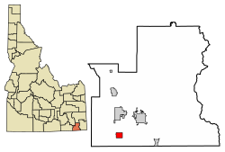
Weston, Idaho | |
---|---|
Coordinates: 42°2′10″N111°58′30″W / 42.03611°N 111.97500°W | |
Country | United States |
State | Idaho |
County | Franklin |
Government | |
• Mayor | Greg Garner |
Area | |
• Total | 1.90 sq mi (4.93 km2) |
• Land | 1.90 sq mi (4.92 km2) |
• Water | 0.01 sq mi (0.01 km2) |
Elevation | 4,744 ft (1,446 m) |
Population | |
• Total | 511 |
• Density | 247.37/sq mi (95.50/km2) |
Time zone | UTC-7 (Mountain (MST)) |
• Summer (DST) | UTC-6 (MDT) |
ZIP code | 83286 |
Area code | 208 |
FIPS code | 16-87040 |
GNIS feature ID | 0375844 |
Weston is a city in Franklin County, Idaho, United States. The population was 511 at the 2020 census. It is part of the Logan, Utah-Idaho Metropolitan Statistical Area. It was first settled in 1865. [3] The community was so named on account of its location at the west bank of the Bear River. [4]
Weston is located at 42°2′10″N111°58′30″W / 42.03611°N 111.97500°W (42.036151, -111.975105). [5]
According to the United States Census Bureau, the city has a total area of 1.98 square miles (5.13 km2), of which, 1.97 square miles (5.10 km2) is land and 0.01 square miles (0.03 km2) is water. [6]
Census | Pop. | Note | %± |
---|---|---|---|
1910 | 308 | — | |
1920 | 452 | 46.8% | |
1930 | 429 | −5.1% | |
1940 | 439 | 2.3% | |
1950 | 382 | −13.0% | |
1960 | 284 | −25.7% | |
1970 | 230 | −19.0% | |
1980 | 310 | 34.8% | |
1990 | 390 | 25.8% | |
2000 | 425 | 9.0% | |
2010 | 437 | 2.8% | |
2020 | 511 | 16.9% | |
U.S. Decennial Census [7] |
As of the census [2] of 2010, there were 437 people, 139 households, and 112 families residing in the city. The population density was 221.8 inhabitants per square mile (85.6/km2). There were 147 housing units at an average density of 74.6 per square mile (28.8/km2). The racial makeup of the city was 98.4% White, 0.5% African American, and 1.1% from two or more races. Hispanic or Latino of any race were 0.5% of the population.
There were 139 households, of which 45.3% had children under the age of 18 living with them, 74.1% were married couples living together, 4.3% had a female householder with no husband present, 2.2% had a male householder with no wife present, and 19.4% were non-families. 18.7% of all households were made up of individuals, and 7.2% had someone living alone who was 65 years of age or older. The average household size was 3.14 and the average family size was 3.63.
The median age in the city was 29 years. 37.1% of residents were under the age of 18; 6.6% were between the ages of 18 and 24; 22.2% were from 25 to 44; 24.9% were from 45 to 64; and 9.2% were 65 years of age or older. The gender makeup of the city was 49.9% male and 50.1% female.
As of the census [8] of 2000, there were 425 people, 118 households, and 105 families residing in the city. The population density was 214.6 inhabitants per square mile (82.9/km2). There were 129 housing units at an average density of 65.1 per square mile (25.1/km2). The racial makeup of the city was 97.18% White, 0.24% Pacific Islander, 1.88% from other races, and 0.71% from two or more races. Hispanic or Latino of any race were 3.29% of the population.
There were 118 households, out of which 56.8% had children under the age of 18 living with them, 81.4% were married couples living together, 5.1% had a female householder with no husband present, and 11.0% were non-families. 11.0% of all households were made up of individuals, and 4.2% had someone living alone who was 65 years of age or older. The average household size was 3.60 and the average family size was 3.84.
In the city, the population was spread out, with 39.5% under the age of 18, 9.9% from 18 to 24, 24.9% from 25 to 44, 17.9% from 45 to 64, and 7.8% who were 65 years of age or older. The median age was 25 years. For every 100 females, there were 103.3 males. For every 100 females aged 18 and over, there were 107.3 males.
The median income for a household in the city was $35,556, and the median income for a family was $35,750. Males had a median income of $31,458 versus $17,188 for females. The per capita income for the city was $10,206. About 8.6% of families and 11.0% of the population were below the poverty line, including 11.8% of those under age 18 and 12.9% of those age 65 or over.
Weston County is a county in the U.S. state of Wyoming. As of the 2020 United States Census, the population was 6,838. Its county seat is Newcastle. Its east boundary line abuts the west line of the state of South Dakota.
Franklin County is a county located in the U.S. state of Idaho. As of the 2020 Census the county had a population of 14,194. The county seat and largest city is Preston. The county was established in 1913 and named after Franklin D. Richards, an Apostle of the Church of Jesus Christ of Latter-day Saints. It is the only Franklin County in the United States that is not named after Benjamin Franklin. Franklin County is part of the Logan, UT-ID Metropolitan Statistical Area.
St. Charles is a city in southern Bear Lake County, Idaho, United States, that is located near the northwestern shore of Bear Lake. Its population was 131 at the 2010 census, down from 156 in 2000.
Bancroft is a city in the Gem Valley in Caribou County, Idaho, United States. The population was 299 at the 2020 census, and 377 at the 2010 census.
Franklin is a city in Franklin County, Idaho, United States. The population was 1,025 at the 2020 census. It is part of the Logan, Utah-Idaho Metropolitan Statistical Area.
Karnak is a village in Pulaski County, Illinois, United States. The population was 499 at the 2010 census.
Minonk is a city in Minonk Township, Woodford County, Illinois. The population was 2,078 at the 2010 census, down from 2,168 in 2000. The city is part of the Peoria, Illinois, metropolitan area.
Orient is a town in Aroostook County, Maine, United States. The population was 156 at the 2020 census.
West Forks is a plantation in Somerset County, Maine, United States. The population was 58 at the 2020 census.
Perry is a town in Washington County, Maine, United States, on the Canada–United States border. At the 2020 census, the town had a population of 802.
South St. Paul is a city in Dakota County, Minnesota, United States, immediately south and southeast of St. Paul and east of West St. Paul. The population was 20,759 at the 2020 census. The town was a major meat-packing location, and many residents are descended from immigrants of Southern European and Eastern European heritage, who came to work in the meat-packing plants in the early twentieth century.
Weston is a village in Saunders County, Nebraska, United States. The population was 250 at the 2020 census.
Freetown is a town in Cortland County, New York, United States. The population was 757 at the 2010 census. Freetown is in the southeastern part of the county and is southeast of Cortland.
New Weston is a village in Darke County, Ohio, United States. The population was 124 at the 2020 census.
Petersboro is a census-designated place (CDP) on the west-central edge of Cache County, Utah, United States. The population was 324 at the 2010 census. It is included in the Logan, Utah-Idaho (partial) Metropolitan Statistical Area.
Mona is a city in Juab County, Utah, United States. As of the 2010 census it had a population of 1,547. It is part of the Provo–Orem metropolitan area.
White City is a city in Salt Lake County, Utah, United States. The city is an enclave of Sandy. The population was 5,407 at the 2010 census, a modest decrease from the 2000 population of 5,988.
Weston is a city in and the county seat of Lewis County, West Virginia, United States. The population was 3,943 at the 2020 census. It is home to the Museum of American Glass in West Virginia and the Trans-Allegheny Lunatic Asylum.
Bridgeport is a hamlet located partly in the town of Sullivan in Madison County, New York, United States and partly in the town of Cicero in Onondaga County. The population was 1,490 at the 2010 census.
Weston is a village in Marathon County, Wisconsin. It is part of the Wausau Metropolitan Statistical Area. The population was 14,868 at the time of the 2010 census.