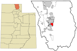
Providence lies 2.5 miles (4.0km) south of Logan on former State Route 238. Its 1990 census population was 3,344. Situated immediately east of the confluence of Spring Creek with the Logan River, the town lies astride a delta at the mouth of Providence Canyon and beneath 8,881-foot (2,707m) Big Baldy Mountain. The settlement was located on Spring Creek to take advantage of water, arable land, timber resources, and existing trails.
As directed by LDS President Brigham Young, on July 24, 1855, Captain Briant Stringham, Simon Baker, Andrew Moffat, and Brigham Young Jr., located headquarters for the Elkhorn Cattle Ranch on a spring of water near the west bank of the Blacksmith Fork River, immediately southwest of the present site of Providence. Subsequently, in the early spring of 1857, Samuel, Joseph, Aboile, and Nephi Campbell, and John Dunn, crossed the mountains from North Ogden into Cache Valley, seeking a new place to settle. To them, the town they called "Ogden's Hole" was becoming too crowded. They pitched camp at the present site of Providence, at a spring and pond where a creek from a canyon in the Bear River Range entered the alluvial lowland. To assess the fertility of the soil, the explorers broke sod and plowed a long furrow.
Plans were made for the immediate resettlement from North Ogden to Cache Valley of the Campbell and other families, but the move was interrupted by the approach of the U.S. Army with orders to force a military occupation of Utah Territory. The Weber County settlers evacuated their homes and moved south for temporary sanctuary on the "Provo bottoms", and the Weber County brigade of the Nauvoo Legion passed through Cache Valley to conduct a defensive reconnoiter of the Bear River region. A number of these men subsequently returned to settle in Providence.
Settlers finally came to Spring Creek on April 20, 1859. Arriving first were Ira Rice, a 65-year-old War of 1812 veteran from Massachusetts, and a 35-year-old Welsh coal miner, Hopkin Mathews, accompanied by his teenage daughter Elizabeth. They were joined by the English-speaking Bowen, Busenbark, Campbell, Clark, Clifford, Dees, Dunn, Durfey, Gates, Hall, Lane, Maddison, Rammell, Thompson, Williams, and Wright families, plus the Gassman, Lau, and Theurer families, whose native tongue was German.
Douglas fir logs were cut and dragged from Spring Creek Canyon to build cabins. The houses faced one another across a narrow road, which could be closed with wagons at each end to make a fort. On April 25, 1859, Peter Maughan visited Spring Creek to establish a religious organization. He chose Samuel Campbell as presiding elder. The first indoor meetings were held in a log meeting-and-schoolhouse erected by John Maddison and William Fife. By August there were 16 families living at the fort; the following month, a child (Hannah Priscilla Thompson) was born at Spring Creek.
On November 14, 1859, LDS apostlesOrson Hyde and Ezra T. Benson organized the Providence Ward. Hyde chose the name: "Spring Creek settlement being situated in an elbow of the mountains and appearing to us somewhat of a providential place, we named Providence." Robert Williams was ordained as bishop. Two years later, when a U.S. post office was established in Providence, Williams was also named postmaster.
In 1860 John Theurer persuaded a number of fellow Swiss LDS converts (whose last names were Alder, Fuhriman, Kresie, Loosli, Naef, Stucki, and Trauber) to come to Spring Creek with its alpine setting. The Swiss tradition of community sauerkraut dinners continues to the present day in Providence. The village became a mix of Yankees, English, and Swiss, united by a common religious persuasion. As Providence was situated astride a Shoshoni trail from a winter camp on the Bear River to Bear Lake via Blacksmith Fork Canyon, church authorities advised that a more substantial fort be erected. A six-foot-high, two-and-one-half-foot-thick rock wall was built to enclose both the log houses and an open commons area.
On November 23, 1862, in the foothills just outside Providence, a two-hour skirmish was fought by 60 soldiers under the command of Major Edward McGarry of the U.S. Second Cavalry against 30 or 40 Shoshone under Chief Bear Hunter.[7] The objective was to recover livestock and a ten-year-old white boy taken during the Utter Party Massacre on the Oregon Trail in August 1860. Three Shoshone people were killed and five others, including Chief Bear Hunter, were captured. An exchange of the captives was made for the boy, Reuben Van Orman, who had been held for two years.
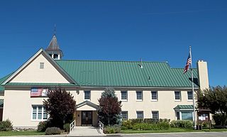
In 1864 the town was laid out into square 8-acre (32,000m2) blocks, each divided into six lots of approximately one and one-third acres. East of Main Street the lots face north–south; they face east–west on the western side of town. The log structures, including the meeting/school building, were relocated from the fort onto the lots under the supervision of Bishop William Budge. On September 4, 1871, James Martineau completed his detailed official survey of Providence City. The cemetery was moved from the south end of town to a hill north of town. Construction was completed in 1871 on a rock meetinghouse and on a rock schoolhouse in 1877. The schoolhouse was replaced by a new building with a bell tower in 1904.
For more than a hundred years, the major activity of most of the people of Providence was farming. Irrigation canals were dug from the Spring Creek and from the Blacksmith Fork and Logan rivers. The livestock industry included the raising of beef cattle (1859), honey bees (1866), horses (1870), dairy cattle (1874), poultry (1918), and foxes (1928). The horticulture industry included growing grain and alfalfa; apple, cherry, pear, and prune orchards; and peas, beans, and sugar beets. Beginning in 1886 Joseph Alastor Smith established Edgewood Hall as a nursery and dairy operation on the bench overlooking Providence. After its 28-room manor burned to the ground on Labor Day of 1935, the 140-acre (0.57km2) estate was acquired by Wall Street financier and Logan native L. Boyd Hatch. An elegant formal estate was created by Hatch, but he sold out in 1953 to cattleman Theron Bringhurst.
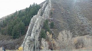
The commercial activities of Providence included private mercantile shops of Rice, Hargraves, and Theurer plus a ZCMI Co-op store (1869–1912). Many years after the Co-op structure burned, Watkins and Sons Printing established a business in a remodeled and expanded facility. Other enterprises included molasses mills, a sawmill, lime kilns, brickyards, blacksmith shops, and an early automobile service station. The sugar factory of David Eccles and Charles Nibley began refining sugar beets in Providence in 1901 and operated for 25 years. Millions of tons of limestone for this and other refineries in the Pacific Northwest were quarried from Providence Canyon. The Utah Idaho Central Railroad Company extended its electric interurban line from Logan and established a depot in Providence in 1912. The railroad hauled limestone, farm produce, and passengers throughout Cache Valley as well as to Corinne, Ogden, and beyond via a connection with the Oregon Short Line Railroad company. Accompanying the UIC were electric lights, the telegraph, and the telephone. The last railroad train ran through town in 1947.
With the coming of statehood to Utah and with the population exceeding 1,000 in the 1890s, Providence was organized as a town corporation. In 1897 Hopkin Mathews became town board president. Providence became a third-class city on 19 July 1929, with James Hansen elected mayor.
Commencing with its first subdivision in 1962, Providence changed at an accelerating pace from a farming community into a "bedroom" suburb of Logan. Fields began to give way to developer tracts of individually owned, single-family houses on small lots. Although there is a spattering of home enterprises, most commercial activities have disappeared from Providence. A major employer of Providence citizens is Utah State University, which at its founding in 1888 seriously considered the Providence bench for its location. Other residents commute to Thiokol Corporation facilities or Hill Air Force Base as well as to smaller business firms and institutions in and around Logan.
This climatic region is typified by large seasonal temperature differences, with warm to hot (and often humid) summers and cold (sometimes severely cold) winters. According to the Köppen Climate Classification system, Providence has a warm summer continental climate, abbreviated "Dfb" on climate maps.[8]
As of the census[5] of 2000, there were 4,377 people, 1,240 households, and 1,082 families residing in the city. The population density was 1,549.0 inhabitants per square mile (598.1/km2). There were 1,290 housing units at an average density of 456.5 per square mile (176.3/km2). The racial makeup of the city was 96.73% White, 0.14% African American, 0.25% Native American, 0.53% Asian, 0.09% Pacific Islander, 1.67% from other races, and 0.59% from two or more races. Hispanic or Latino of any race were 2.06% of the population.
There were 1,240 households, out of which 50.2% had children under the age of 18 living with them, 79.0% were married couples living together, 6.5% had a female householder with no husband present, and 12.7% were non-families. 11.9% of all households were made up of individuals, and 6.3% had someone living alone who was 65 years of age or older. The average household size was 3.51 and the average family size was 3.84.
In the city, the population was spread out, with 36.6% under the age of 18, 10.6% from 18 to 24, 24.6% from 25 to 44, 19.0% from 45 to 64, and 9.2% who were 65 years of age or older. The median age was 28 years. For every 100 females, there were 98.5 males. For every 100 females age 18 and over, there were 94.7 males.
The median income for a household in the city was $56,129, and the median income for a family was $58,856. Males had a median income of $39,306 versus $27,074 for females. The per capita income for the city was $21,201. About 2.5% of families and 3.2% of the population were below the poverty line, including 2.0% of those under age 18 and 7.5% of those age 65 or over.
Notable people
Nephi Miller, pioneer in the modern practice of migratory beekeeping
Cache County is a county located in the Wasatch Front region of Utah. As of the 2020 United States Census, the population was 133,154, with an estimated 140,173 in 2022. Its county seat and largest city is Logan. Cache County is one of two counties included in the Logan metropolitan area, alongside Franklin County, Idaho.
Rich County is a county in the U.S. state of Utah. As of the 2020 United States Census, the population was 2,510, making it the third-least populous county in Utah. Its county seat is Randolph, and the largest town is Garden City. The county was created in 1864. It was named for an early LDS apostle, Charles C. Rich.
Morgan County is a county in northern Utah, United States. As of the 2020 census, the population was 12,295. Its county seat and largest city is Morgan. Morgan County is part of the Ogden-Clearfield, UT Metropolitan Statistical Area as well as the Salt Lake City-Provo-Orem, UT Combined Statistical Area.
Weber County is a county in the U.S. state of Utah. As of the 2020 census, the population was 262,223, making it Utah's fourth-most populous county. Its county seat and largest city is Ogden, the home of Weber State University. The county was named after a fur trapper John Weber.
Preston is a city in Franklin County, Idaho, United States. The population was 5,591 at the 2020 census, up from 5,204 at the 2010 census. The city is the county seat of Franklin County. It is part of the Logan, Utah-Idaho Metropolitan Statistical Area.
Brigham City is a city in Box Elder County, Utah, United States. The population was 19,650 at the 2020 census, up from the 2010 figure of 17,899. It is the county seat of Box Elder County. It lies on the western slope of the Wellsville Mountains, a branch of the Wasatch Range at the western terminus of Box Elder Canyon. It is near the former headquarters of ATK Thiokol, now Northrop Grumman, the company that created the solid rocket boosters for the Space Shuttle.
Perry is a city in Box Elder County, Utah, United States. The population was 4,512 at the 2010 census.
Willard is a city in Box Elder County, Utah, United States. The population was 1,978 at the 2020 census.
Amalga is a town in Cache County, Utah, United States. The population was 482 at the 2020 census. It is included in the Logan, Utah-Idaho (partial) Metropolitan Statistical Area.
Hyrum is a city in Cache County, Utah. The population was 9,362 at the time of the 2020 census. It is included in the Logan metropolitan statistical area.
Logan is a city in Cache County, Utah, United States. The 2020 census recorded the population was 52,778. Logan is the county seat of Cache County and the principal city of the Logan metropolitan area, which includes Cache County and Franklin County, Idaho. The Logan metropolitan area contained 147,908 people as of the 2020 census. Logan is the location of the main campus of Utah State University.
Smithfield is a city in Cache County, Utah, United States. The population was 13,571 at the 2020 United States Census, It is included in the Logan, Utah–Idaho Metropolitan Statistical Area, and is the second largest city in the area after Logan, the county seat. Smithfield is home to Sky View High School and three public elementary schools.
Morgan is a city in the U.S. state of Utah and the county seat of Morgan County. It is part of the Ogden-Clearfield metropolitan area. It is named after Jedediah Morgan Grant, a leader in the Church of Jesus Christ of Latter-day Saints who served as an apostle and as a member of the LDS First Presidency under Brigham Young in the mid-1850s. As of the 2020 census, the city population was 4,071 people. Morgan is also a location where some of the movie Troll 2 was filmed in 1989.
Oakley is a city in Summit County, Utah, United States. It is part of the Salt Lake City, Utah Metropolitan Statistical Area. The population was 1,470 at the 2010 census.
North Ogden is a city in Weber County, Utah, United States. The population was 20,916 at the 2020 census. North Ogden is on SR-235, three miles north of Ogden. It is a suburb of that city and is part of the Ogden-Clearfield, Utah Metropolitan Statistical Area.
South Ogden is a city in Weber County, Utah, United States with 17,199 residents. The population was 16,532 at the 2010 census. It is part of the Ogden–Clearfield, Utah Metropolitan Statistical Area. The current mayor is Russell L. Porter.
Uintah is a city in Weber County, Utah, United States. The population was 1,322 at the 2010 census. It is part of the Ogden–Clearfield, Utah Metropolitan Statistical Area. Although Uintah was a town in 2000, it has since been classified as a fifth-class city by state law.
The Bear River Massacre, or the Engagement on the Bear River, or the Battle of Bear River, or Massacre at Boa Ogoi, took place in present-day Franklin County, Idaho, on January 29, 1863. After years of skirmishes and food raids on farms and ranches, the United States Army attacked a Shoshone encampment gathered at the confluence of the Bear River and Battle Creek in what was then southeastern Washington Territory, near the present-day city of Preston. Colonel Patrick Edward Connor led a detachment of California Volunteers as part of the Bear River Expedition against Shoshone tribal chief Bear Hunter. Hundreds of Shoshone men, women, and children were killed near their lodges; the number of Shoshone victims reported by local settlers was higher than that reported by soldiers.
Cache Valley(Shoshoni: Seuhubeogoi, “Willow Valley”) is a valley of northern Utah and southeast Idaho, United States, that includes the Logan metropolitan area. The valley was used by 19th century mountain men and was the site of the 1863 Bear River Massacre. The name, Cache Valley is often used synonymously to describe the Logan Metropolitan Area, one of the fastest growing metro areas in the US per capita — both in terms of economic GDP and population.
Sagwitch Timbimboo, which translates to "Speaker" and "One Who Writes on Rocks," was a nineteenth-century chieftain of a band of Northwestern Shoshone that converted to The Church of Jesus Christ of Latter-day Saints. Of his tribe, he was one of the very few survivors of the horrific Bear River Massacre, which is considered the greatest loss of Indigenous life through wars with Anglo-Saxon people. Within the battle, Chief Sagwitch led his people away from the preemptive attack that the United States government had levied upon the people. Losing the majority of his own tribe, Chief Sagwitch helped rebuild his tribe and as the leader, led his people to a thriving life. Living the majority of his life in what is now Cache Valley, which is located in Northeast Utah and Southeast Idaho, Chief Sagwitch was an instrumental leader within the Shoshone Tribe and within the Church of Jesus Christ of Latter-day Saints. Helping build a temple with the Latter-day Saints in Logan, Utah, Chief Sagwitch became an Elder for the Church shortly after his conversion in 1873. Along with Chief Sagwitch being baptized, 101 of His tribe members also took the oath of baptism. Chief Sagwitch died on March 20, 1887, leaving a lasting legacy as an influential member of the Indigenous community.
References
↑ "City Council". Providence City, UT. Retrieved December 31, 2021.
This page is based on this Wikipedia article Text is available under the CC BY-SA 4.0 license; additional terms may apply. Images, videos and audio are available under their respective licenses.