Trenton, Utah

Last updated

Trenton, Utah
Trenton, Utah (8114907787).jpg
Looking south across Main Street (Utah State Route 142) and along Center Street in Trenton, September 2012
Cache County Utah incorporated and unincorporated areas Trenton highlighted.svg
Location in Cache County and the state of Utah.
Coordinates: 41°54′44″N111°56′27″W / 41.91222°N 111.94083°W / 41.91222; -111.94083
Country United States
State Utah
County Cache
Settled1870
Named for Trenton, New Jersey
Area
[1]
  Total8.29 sq mi (21.47 km2)
  Land8.21 sq mi (21.26 km2)
  Water0.08 sq mi (0.21 km2)
Elevation
[2]
4,462 ft (1,360 m)
Population
 (2020)
  Total512
  Estimate 
(2019) [3]
552
  Density67.25/sq mi (25.97/km2)
Time zone UTC-7 (Mountain (MST))
  Summer (DST) UTC-6 (MDT)
ZIP code
84338
Area code 435
FIPS code 49-77230 [4]
GNIS feature ID1433666 [2]

Trenton is a town in Cache County, Utah, United States. The population was 512 at the 2020 census. It is included in the Logan, Utah-Idaho (partial) Metropolitan Statistical Area.

Contents

Geography

According to the United States Census Bureau, the town has a total area of 7.3 square miles (19.0 km2), of which 7.2 square miles (18.8 km2) is land and 0.1 square mile (0.2 km2) (1.23%) is water.

Climate

This climatic region is typified by large seasonal temperature differences, with warm to hot summers and cold (sometimes severely cold) winters. According to the Köppen Climate Classification system, Trenton has a humid continental climate, abbreviated "Dsb" on climate maps. [5]

Climate data for Trenton, Utah, (1991–2020 normals, extremes 1944–1948 and 1976–present)
MonthJanFebMarAprMayJunJulAugSepOctNovDecYear
Record high °F (°C)60
(16)
64
(18)
76
(24)
85
(29)
94
(34)
100
(38)
103
(39)
102
(39)
99
(37)
87
(31)
74
(23)
62
(17)
103
(39)
Mean maximum °F (°C)46.6
(8.1)
50.9
(10.5)
66.7
(19.3)
77.2
(25.1)
85.0
(29.4)
92.2
(33.4)
97.1
(36.2)
96.6
(35.9)
90.3
(32.4)
79.2
(26.2)
63.5
(17.5)
51.1
(10.6)
98.1
(36.7)
Mean daily maximum °F (°C)31.7
(−0.2)
37.0
(2.8)
49.9
(9.9)
59.1
(15.1)
68.9
(20.5)
79.3
(26.3)
88.8
(31.6)
87.6
(30.9)
77.2
(25.1)
62.7
(17.1)
47.1
(8.4)
33.8
(1.0)
60.3
(15.7)
Daily mean °F (°C)21.9
(−5.6)
26.8
(−2.9)
37.7
(3.2)
45.4
(7.4)
53.9
(12.2)
62.3
(16.8)
70.1
(21.2)
68.1
(20.1)
58.5
(14.7)
46.6
(8.1)
34.8
(1.6)
24.1
(−4.4)
45.9
(7.7)
Mean daily minimum °F (°C)12.1
(−11.1)
16.7
(−8.5)
25.6
(−3.6)
31.7
(−0.2)
39.0
(3.9)
45.3
(7.4)
51.4
(10.8)
48.6
(9.2)
39.8
(4.3)
30.5
(−0.8)
22.6
(−5.2)
14.4
(−9.8)
31.5
(−0.3)
Mean minimum °F (°C)−5.0
(−20.6)
0.1
(−17.7)
11.6
(−11.3)
22.8
(−5.1)
28.5
(−1.9)
35.8
(2.1)
43.6
(6.4)
39.5
(4.2)
30.5
(−0.8)
20.5
(−6.4)
9.4
(−12.6)
−3.5
(−19.7)
−9.8
(−23.2)
Record low °F (°C)−32
(−36)
−36
(−38)
−11
(−24)
10
(−12)
21
(−6)
28
(−2)
34
(1)
26
(−3)
19
(−7)
3
(−16)
−17
(−27)
−29
(−34)
−36
(−38)
Average precipitation inches (mm)1.51
(38)
1.42
(36)
1.70
(43)
2.04
(52)
2.19
(56)
1.20
(30)
0.56
(14)
0.83
(21)
1.26
(32)
1.54
(39)
1.25
(32)
1.40
(36)
16.90
(429)
Average snowfall inches (cm)13.6
(35)
10.4
(26)
4.2
(11)
1.9
(4.8)
0.1
(0.25)
0.0
(0.0)
0.0
(0.0)
0.0
(0.0)
0.0
(0.0)
0.4
(1.0)
4.9
(12)
13.5
(34)
49.0
(124)
Average precipitation days (≥ 0.01 in)10.28.99.010.511.06.04.04.35.47.47.410.194.2
Average snowy days (≥ 0.1 in)7.15.82.81.00.10.00.00.00.00.42.97.127.2
Source: NOAA [6] [7]

Demographics

Historical population
CensusPop.Note
1880 209
1890 24617.7%
1900 227−7.7%
1910 2489.3%
1920 551122.2%
1930 531−3.6%
1940 5534.1%
1950 451−18.4%
1960 448−0.7%
1970 390−12.9%
1980 44714.6%
1990 4643.8%
2000 449−3.2%
2010 4643.3%
2020 51210.3%
U.S. Decennial Census [8]

As of the census [4] of 2000, there were 449 people, 135 households, and 110 families residing in the town. The population density was 62.0 inhabitants per square mile (23.9/km2). There were 145 housing units at an average density of 20.0 per square mile (7.7/km2). The racial makeup of the town was 95.55% White, 0.22% African American, 0.89% Native American, 0.45% Asian, 2.45% from other races, and 0.45% from two or more races. Hispanic or Latino of any race were 5.35% of the population.

There were 135 households, out of which 51.1% had children under the age of 18 living with them, 74.1% were married couples living together, 5.9% had a female householder with no husband present, and 18.5% were non-families. 16.3% of all households were made up of individuals, and 8.1% had someone living alone who was 65 years of age or older. The average household size was 3.33 and the average family size was 3.79.

In the town, the population was spread out, with 36.7% under the age of 18, 11.6% from 18 to 24, 25.4% from 25 to 44, 17.8% from 45 to 64, and 8.5% who were 65 years of age or older. The median age was 26 years. For every 100 females, there were 112.8 males. For every 100 females age 18 and over, there were 110.4 males.

The median income for a household in the town was $31,250, and the median income for a family was $40,139. Males had a median income of $31,023 versus $20,833 for females. The per capita income for the town was $11,910. About 6.3% of families and 9.1% of the population were below the poverty line, including 10.8% of those under age 18 and 11.8% of those age 65 or over.

Notable people

See also

Related Research Articles

<span class="mw-page-title-main">Trenton, Maine</span> Town in the state of Maine, United States

Trenton is a town in Hancock County, Maine, United States, near Acadia National Park. The population was 1,584 at the 2020 census. Hancock County-Bar Harbor Airport is located in Trenton.

<span class="mw-page-title-main">Portage, Utah</span> Town in Utah, United States

Portage is a town in Box Elder County, Utah, United States. The population was 245 at the 2010 census. The town received its name from Lorenzo Snow, an apostle of the Church of Jesus Christ of Latter-day Saints. He named it Portage after his birthplace of Portage County, Ohio.

<span class="mw-page-title-main">Lewiston, Utah</span> City in Utah, United States

Lewiston is a city in Cache County, Utah, United States. It is situated at the northern Utah border and borders the state of Idaho. The population was 1,939 at the 2020 census. It is included in the Logan, Utah-Idaho (partial) Metropolitan Statistical Area.

<span class="mw-page-title-main">Hatch, Utah</span> Town in the state of Utah, United States

Hatch is a town in Garfield County, Utah, United States. The population was 132 at the 2020 census. It is 260 miles (420 km) south of Salt Lake City.

<span class="mw-page-title-main">Henrieville, Utah</span> Town in the state of Utah, United States

Henrieville is a town in Garfield County, Utah, United States, along Utah Scenic Byway 12. As of the 2020 census, the town population was 221.

<span class="mw-page-title-main">Nephi, Utah</span> City in and county seat of Juab County, Utah, United States

Nephi is a city in Juab County, Utah, United States. It is part of the Provo–Orem metropolitan area. The population was 6,443 at the 2020 census. It is the county seat of Juab County. It was settled by Mormon pioneers in 1851 as Salt Creek, and it acquired its current name in 1882. It is the principal city in the Juab Valley, an agricultural area. Nephi was named after Nephi, son of Lehi, from the Book of Mormon.

<span class="mw-page-title-main">Hinckley, Utah</span> Town in the state of Utah, United States

Hinckley is a town in Millard County, Utah, United States, in the middle of the Sevier Desert. Irrigation water from the Sevier River, passing nearby, has been used to turn Hinckley into a farming oasis. The mountains that are common in Utah are seen only in the distance, and beyond the reach of the river, a severe desert prevails. The population was 614 at the 2020 census.

<span class="mw-page-title-main">Meadow, Utah</span> Town in the state of Utah, United States

Meadow is a town in Millard County, Utah, United States. The population was 254 at the 2000 census. Originally called Meadow Creek, the town is located about eight miles south of Fillmore.

<span class="mw-page-title-main">Junction, Utah</span> Town in the state of Utah, United States

Junction is a town in and the county seat of Piute County, Utah, United States. The population was 191 at the 2010 census.

<span class="mw-page-title-main">Marysvale, Utah</span> Town in the United States

Marysvale is a town in Piute County, Utah, United States. The population was 408 at the 2010 census. Marysvale is a trail head for the Paiute ATV Trail.

<span class="mw-page-title-main">Laketown, Utah</span> Town in the state of Utah, United States

Laketown is a town in Rich County, Utah, United States. The population was 248 at the 2010 census. The town is named for nearby Bear Lake.

<span class="mw-page-title-main">Woodruff, Utah</span> Town in Utah, United States

Woodruff is a town in Rich County, Utah, United States. The population was 180 at the 2010 census.

<span class="mw-page-title-main">Sterling, Utah</span> Town in Utah, United States

Sterling is a town in Sanpete County, Utah, United States. The population was 235 at the 2000 census.

<span class="mw-page-title-main">Redmond, Utah</span> Town in the state of Utah, United States

Redmond is a town in Sevier County, Utah, United States. The population was 730 at the 2010 census. Redmond was first settled in 1876, and named for red mounds to the west of the town.

<span class="mw-page-title-main">Henefer, Utah</span> Town in Utah, United States

Henefer is a town in Summit County, Utah, United States. It is part of the Salt Lake City, Utah Metropolitan Statistical Area. The population was 766 at the 2010 census.

<span class="mw-page-title-main">Rush Valley, Utah</span> Town in the state of Utah, United States

Rush Valley is a town in Tooele County, Utah, United States, located in the northwest of Rush Valley. It is part of the Salt Lake City, Utah Metropolitan Statistical Area. The population was 447 at the 2010 census, with an estimate population of 494 in 2019.

<span class="mw-page-title-main">Leeds, Utah</span> Town in Washington County, Utah

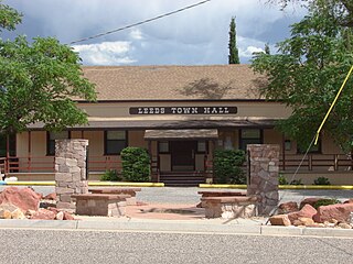
Leeds is a town in Washington County, Utah, United States. The population was 820 at the 2010 census.

<span class="mw-page-title-main">New Harmony, Utah</span> Town in the state of Utah, United States

New Harmony is a town in northern Washington County, Utah, United States. The population was 207 at the 2010 census.

<span class="mw-page-title-main">Rockville, Utah</span> Town in the state of Utah, United States

Rockville is a town in Washington County, Utah, United States. It is located along the Virgin River near the mouth of Zion Canyon. The city lies just outside the park boundary for Zion National Park; the park entrance is located approximately 5 miles (8 km) northeast of the town.

<span class="mw-page-title-main">Uintah, Utah</span> City in Utah, United States

Uintah is a city in Weber County, Utah, United States. The population was 1,322 at the 2010 census. It is part of the Ogden–Clearfield, Utah Metropolitan Statistical Area. Although Uintah was a town in 2000, it has since been classified as a fifth-class city by state law.

References

  1. "2019 U.S. Gazetteer Files". United States Census Bureau. Retrieved August 7, 2020.
  2. 1 2 U.S. Geological Survey Geographic Names Information System: Trenton
  3. "Population and Housing Unit Estimates". United States Census Bureau. May 24, 2020. Retrieved May 27, 2020.
  4. 1 2 "U.S. Census website". United States Census Bureau . Retrieved January 31, 2008.
  5. Climate Summary for Trenton, Utah
  6. "NOWData – NOAA Online Weather Data". National Oceanic and Atmospheric Administration. Retrieved November 25, 2022.
  7. "Summary of Monthly Normals 1991–2020". National Oceanic and Atmospheric Administration. Retrieved November 29, 2022.
  8. "Census of Population and Housing". Census.gov. Retrieved June 4, 2015.