
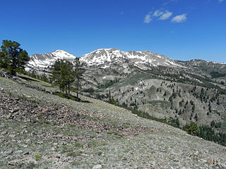
The Sawtooth Wilderness is a federally-protected wilderness area that covers 217,088 acres (87,852 ha) of the state of Idaho. Managed by the U.S. Forest Service in the U.S. Department of Agriculture, it was designated the Sawtooth Primitive Area in 1937 to preserve the exceptional scenic beauty of the Sawtooth Mountains. On August 22, 1972 Public Law 92-400 designated the Primitive Area as the Sawtooth Wilderness and part of the newly created Sawtooth National Recreation Area. As part of the National Wilderness Preservation System, the Sawtooth Wilderness is an area where human development and use are restricted and people are to remain only visitors. According to the United States Environmental Protection Agency, the Sawtooth Wilderness has some of the clearest air in the lower 48 states.

Thompson Peak, at 10,751 feet (3,277 m) above sea level is the highest peak in the Sawtooth Range of Idaho. The summit of Thompson Peak is located within Custer County, although some of the lower portion of the mountain is in Boise County. Thompson Peak is also located within the Sawtooth Wilderness portion of the Sawtooth National Recreation Area, a unit of Sawtooth National Forest. The town of Stanley, Idaho is about 6 miles (9.7 km) northeast of Thompson Peak.
Alice Lake is an alpine lake in the western United States in central Idaho, located high in the Sawtooth Mountains in the Sawtooth National Recreation Area. In Blaine County, the lake is one of the largest in the Sawtooth Wilderness and is most easily accessed via the trailhead at Pettit Lake, accessed from State Highway 75 via Sawtooth National Forest road 208.

Baron Lake is an alpine lake in Boise County, Idaho, United States, located in the Sawtooth Mountains in the Sawtooth National Recreation Area. Sawtooth National Forest trail 101 goes to the lake.
Smoky Dome, at 10,095 feet (3,077 m) above sea level is the highest peak in the Soldier Mountains of Idaho. Smoky Dome is located northwest of Fairfield in Camas County and Sawtooth National Forest.
Boardman Peak, at 9,457 feet (2,882 m) high is one of the peaks of the Soldier Mountains of Idaho. Boardman Peak is located at the center of the range southeast of Iron Mountain, northwest of Smoky Dome, and northwest of Fairfield in Camas County and Sawtooth National Forest. No trails go to the summit, but several pass near the peak, and the ascent is only class 2.
Cache Peak, at 10,339 feet (3,151 m) above sea level, is the highest peak in the Albion Mountains of Cassia County in Southern Idaho. Cache Peak is located in the central part of the range southeast of Oakley and north of Almo in the Albion Division of the Minidoka Ranger District of Sawtooth National Forest.

Mount Harrison, at 9,265 feet (2,824 m) is a peak in the northern Albion Mountains of Cassia County in southern Idaho. Mount Harrison is located in north of Cache Peak, south of Burley, northeast of Oakley, and west of Malta in the Albion Division of the Minidoka Ranger District of Sawtooth National Forest. Mount Harrison is in the watershed of tributaries of the Snake River, which itself is a tributary of the Columbia River. The peak can be reached via a paved road that runs all the way to its summit. Lake Cleveland is located in the basin north of the peak, and a small unnamed lake is located in the basin southeast of the peak.

Baker Lake is an alpine lake in Blaine County, Idaho, United States, located in the Smoky Mountains in Sawtooth National Forest. The lake is most easily accessed via a trail from the end of forest road 162. The lake is located just east of Backdrop Peak and north of Baker Peak.
Big Lost Lake is an alpine lake in Blaine County, Idaho, United States, located in the Smoky Mountains in Sawtooth National Forest. The lake is most easily accessed via trail 135 from the end of forest road 170. The lake is located just east of Prairie Creek Peak. It is also near Smoky Lake, Little Lost Lake, and Upper and Lower Norton lakes.

Lower Norton Lake is an alpine lake in Blaine County, Idaho, United States, located in the Smoky Mountains in Sawtooth National Forest. It is most easily accessed from trail 135 from the end of forest road 170. The lake is located east of Prairie Creek Peak. It is also near Smoky Lake, Big Lost Lake, Little Lost Lake, and Upper Norton Lake.
Upper Norton Lake is an alpine lake in Blaine County, Idaho, United States, located in the Smoky Mountains in Sawtooth National Forest. It is most easily accessed from trail 135 from the end of forest road 170. The lake is located northeast of Prairie Creek Peak. It is also near Smoky Lake, Big Lost Lake, Little Lost Lake, and Lower Norton Lake.
Smoky Lake is an alpine lake in Blaine County, Idaho, United States, located in the Smoky Mountains in Sawtooth National Forest. While no trails lead to the lake, it is most easily accessed from the end of forest road 170. The lake is located just southeast of Prairie Creek Peak. It is also near Little Lost Lake, Big Lost Lake, and Upper and Lower Norton lakes.
Dollar Lake is a lake in Blaine County, Idaho, United States, located in the Smoky Mountains in Sawtooth National Forest. The lake is located along Warm Springs Creek along forest road 227 just south of Penny Lake and east of the town of Ketchum.
Mount Independence is the second highest peak in the Albion Mountains of Idaho. The peak is located in Sawtooth National Forest and Cassia County. It is located about 1 mi (1.6 km) northwest of Cache Peak. The Independence Lakes are located in the basin to the east of the peak. Mount Independence supports one of the three populations of Cymopterus davisii, a plant that is endemic to the Albion Mountains. The Mount Independence population is considered a single population with Cache Peak. Mount Independence is 9,950 feet (3,030 m) above sea level.
Graham Peak is the fourth highest peak in the Albion Mountains of Idaho, at 8,867 feet (2,703 m) above sea level. The peak is located in the City of Rocks National Reserve and Cassia County less than 0.2 mi (0.32 km) south of the Sawtooth National Forest border. It is located 5.13 mi (8.26 km) south-southwest of Cache Peak. Forest road 707 leads directly to the summit. The peak contains the smallest of the three known populations of Cymopterus davisii, estimated at 500–1000 individuals.
Smoky Mountain, at 7,579 feet (2,310 m) above sea level is a peak in the Albion Mountains of Idaho. The peak is located in Cassia County about 0.35 mi (0.56 km) east of the border of City of Rocks National Reserve on land managed by the Bureau of Land Management. It is 4.7 mi (7.6 km) north of the Nevada border.
Prairie Creek Peak, at 10,138 feet (3,090 m) above sea level is the sixth highest peak in the Smoky Mountains of Idaho. The peak is located on the border of both Sawtooth National Forest and Sawtooth National Recreation Area and Blaine and Camas counties. It is located about 1.5 mi (2.4 km) southwest of Norton Peak, west of Big Lost Lake, southeast of the Prairie Lakes, and northwest of Smoky and Little Lost lakes. No roads or trails go to the summit.
Paradise Peak, at 9,798 feet (2,986 m) above sea level is a peak in the Smoky Mountains of Idaho. The peak is located in Sawtooth National Forest in Camas County. It is located in the watersheds of Paradise and Emma creeks and the South Fork of the Boise River. It is about 4 mi (6.4 km) northwest of Skillern Peak, 0.35 mi (0.56 km) northwest of Paradise Lake, and 1.2 mi (1.9 km) west of Snowslide Lake. No roads or trails go to the summit.

Packrat Peak, at 10,240 feet (3,120 m) above sea level is a peak in the Sawtooth Range of Idaho. The peak is located in the Sawtooth Wilderness of Sawtooth National Recreation Area on the border of Boise and Custer counties. The peak is located 2.38 mi (3.83 km) north of Elk Peak, its line parent. Warbonnet and Little Warbonnet lakes are in the basin north of the peak.

