
The Lake Chelan-Sawtooth Wilderness is a 153,057-acre (61,940 ha) protected wilderness area located within the Okanogan and Wenatchee national forests in Washington State. The wilderness borders Lake Chelan National Recreation Area and North Cascades National Park and the Stephen Mather Wilderness to the northwest. It was designated with the passage of the Washington Wilderness Act of 1984, on lands occupied by the old Chelan Division of the Washington Forest Reserve, now part of both the Okanogan and Wenatchee national forests.

The Sawtooth National Recreation Area (SNRA) is a national recreation area in central Idaho, United States that is managed as part of Sawtooth National Forest. The recreation area, established on August 22, 1972, is managed by the U.S. Forest Service, and includes the Sawtooth, Hemingway–Boulders, and Cecil D. Andrus–White Clouds wilderness areas. Activities within the 730,864-acre (2,957.70 km2) recreation area include hiking, backpacking, White water rafting, camping, rock climbing, kayaking, mountain biking, fishing, and hunting.

The Sawtooth Range is a mountain range of the Rocky Mountains in central Idaho, United States, reaching a maximum elevation of 10,751 feet (3,277 m) at the summit of Thompson Peak. It encompasses an area of 678 square miles (1,756 km2) spanning parts of Custer, Boise, Blaine, and Elmore counties, and is bordered to the east by the Sawtooth Valley. Much of the mountain range is within the Sawtooth Wilderness, part of the Sawtooth National Recreation Area and Sawtooth National Forest.

Thompson Peak, at 10,751 feet (3,277 m) above sea level is the highest peak in the Sawtooth Range of Idaho. The summit of Thompson Peak is located within Custer County, although some of the lower portion of the mountain is in Boise County. Thompson Peak is also located within the Sawtooth Wilderness portion of the Sawtooth National Recreation Area, a unit of Sawtooth National Forest. The town of Stanley, Idaho is about 6 miles (9.7 km) northeast of Thompson Peak.

Mount Heyburn, at 10,229 feet (3,118 m) is one of the many 10,000-foot (3,050 m) peaks in the Sawtooth Range of central Idaho. Mount Heyburn is located in Custer County and within the Sawtooth Wilderness portion of the Sawtooth National Recreation Area. The town of Stanley is located eight miles (13 km) north-northeast of Mount Heyburn. Grand Mogul, 9,733 ft (2,967 m), and Mount Heyburn are the two signature peaks that frame the southwest end of Redfish Lake ; all are in the Salmon River watershed.

The White Cloud Mountains are part of the Rocky Mountains of the western United States, located in central Idaho, southeast of Stanley in Custer County. The range is located within the Sawtooth National Recreation Area (SNRA) and partially within the Cecil D. Andrus–White Clouds Wilderness.

The Smoky Mountains are part of the Rocky Mountains and located on the west side of the Wood River Valley near Sun Valley, Idaho, in the Western United States. The range is within Sawtooth National Forest, while part of it is within the Sawtooth National Recreation Area. The highest point in the range is Saviers Peak at 10,441 ft (3,182 m).

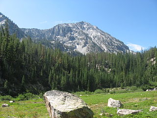
Iron Mountain, at 9,694 feet (2,955 m) high is one of the peaks of the Soldier Mountains of Idaho. Iron Mountain is located at the west end of the range northwest of Fairfield in Camas County and Sawtooth National Forest.

Merriam Peak, at 10,920 feet (3,330 m) is one of the peaks of the White Cloud Mountains of Custer County, Idaho. It was named for John H. Merriam who played an instrumental role in protecting the area from being mined for molybdenum. Merriam Peak is located in the middle of the range just north of Castle Peak, the highest point in the range. The peak is located in the White Clouds roadless area of Sawtooth National Recreation Area.
Prairie Creek Peak, at 10,138 feet (3,090 m) above sea level is the sixth highest peak in the Smoky Mountains of Idaho. The peak is located on the border of both Sawtooth National Forest and Sawtooth National Recreation Area and Blaine and Camas counties. It is located about 1.5 mi (2.4 km) southwest of Norton Peak, west of Big Lost Lake, southeast of the Prairie Lakes, and northwest of Smoky and Little Lost lakes. No roads or trails go to the summit.
Paradise Peak, at 9,798 feet (2,986 m) above sea level is a peak in the Smoky Mountains of Idaho. The peak is located in Sawtooth National Forest in Camas County. It is located in the watersheds of Paradise and Emma creeks and the South Fork of the Boise River. It is about 4 mi (6.4 km) northwest of Skillern Peak, 0.35 mi (0.56 km) northwest of Paradise Lake, and 1.2 mi (1.9 km) west of Snowslide Lake. No roads or trails go to the summit.

Warbonnet Peak is located in the Sawtooth Wilderness of Sawtooth National Recreation Area in Boise County. The peak is located 0.17 mi (0.27 km) west-northwest of Cirque Lake Peak, its line parent.

Cirque Lake Peak, at 10,210 feet (3,110 m) above sea level is a peak in the Sawtooth Range of Idaho. The peak is located in the Sawtooth Wilderness of Sawtooth National Recreation Area in Boise County. The peak is located 1.39 mi (2.24 km) north-northwest of Packrat Peak, its line parent.
Dave's Peak, at 10,579 feet (3,224 m) above sea level is an unofficially named peak that is the ninth highest peak in the Sawtooth Range of Idaho. The peak is located in the Sawtooth Wilderness of Sawtooth National Recreation Area in Custer County. The peak is located 0.65 mi (1.05 km) northeast of Mount Cramer, its line parent. Profile and Lucille lakes are southeast of the peak, while Upper, Middle, and Lower Cramer lakes are northwest of the peak. Dave's Peak is south-southwest of Sevy Peak.

Mount Regan, rises 10,190 feet (3,110 m) above sea level, and is a peak in the Sawtooth Range of Idaho. The peak is located in the Sawtooth Wilderness of Sawtooth National Recreation Area on the border of Boise and Custer counties. The peak is located 1.9 mi (3.1 km) west of Merritt Peak, its line parent. The peak is named after Timothy Regan, a pioneer who lived in Silver City, and then Boise. Mount Regan is located at the southern end of Sawtooth Lake. The Trailer Lakes and Regan Lake are located northwest of the peak, and the Trail Creek Lakes are west of the peak.
Parks Peak, at 10,280 feet (3,130 m) above sea level is a peak in the Sawtooth Range of Idaho. The peak is located in the Sawtooth Wilderness of Sawtooth National Recreation Area on the border of Blaine and Custer counties. The peak is located 2.78 mi (4.47 km) northeast of Snowyside Peak, its line parent, and 1.9 mi (3.1 km) northwest of McDonald Peak. Farley Lake is north of the peak and Bowknot and Toxaway lakes are west of the peak.
Imogene Peak, at 10,125 feet (3,086 m) above sea level is a peak in the Sawtooth Range of Idaho. The peak is located in the Sawtooth Wilderness of Sawtooth National Recreation Area in Custer County. The peak is located 1.83 mi (2.95 km) north of Parks Peak, its line parent. Farley Lake is located south of the peak, and Imogene Lake is west of the peak.

Alpine Peak, at 9,861 feet (3,006 m) above sea level is a peak in the Sawtooth Range of Idaho. The peak is located in the Sawtooth Wilderness of Sawtooth National Recreation Area in Custer County. The peak is located 1 mi (1.6 km) northeast of Mount Regan, its line parent. Alpine Peak is south of Alpine Lake and east of Sawtooth Lake.

Lonesome Lake Peak, also known as Lonesome Peak, at 11,302 feet (3,445 m) above sea level is a peak in the White Cloud Mountains of Idaho. The peak is located in Sawtooth National Recreation Area in Custer County. The peak is located 2.07 mi (3.33 km) south-southeast of D. O. Lee Peak, its line parent. It is the 68th highest peak in Idaho and rises above the west side of Lonesome Lake, the uppermost of the Boulder Chain Lakes.

