
Minidoka County is a county located in the U.S. state of Idaho. As of the 2020 census, the population was 21,613. The county seat and largest city is Rupert.

Bingham County is a county in the U.S. state of Idaho. As of the 2020 United States Census, the population was 47,992. The county seat and largest city is Blackfoot.

The Wood River Valley is a region in the western United States in south-central Idaho. Located in Blaine County, it is named after the Big Wood and Little Wood Rivers, which flow through the area.
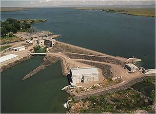
The Minidoka Dam is an earthfill dam in the western United States, on the Snake River in south central Idaho. Completed in 1906, the dam is east of Rupert on county highway 400; it is 86 feet (26 m) high and nearly a mile (1.6 km) in length, with a 2,400-foot (730 m) wide overflow spillway section.

Lake Cascade, is a reservoir in the western United States, on the North Fork of the Payette River in Valley County, Idaho. Located in the Boise National Forest, it has a surface area of 47 square miles (122 km2), and is the fourth largest lake or reservoir in the state. The closest cities are Cascade, Donnelly, and McCall, all in the Long Valley of Valley County.

Owyhee Reservoir or Owyhee Lake is a reservoir on the Owyhee River in Malheur County, Oregon, United States. Located in far Eastern Oregon near the Idaho border, the reservoir is Oregon's longest at 52 miles (84 km). The 13,900-acre (56 km2) lake is home to several species of fish, including crappie, rainbow trout, largemouth bass, smallmouth bass, yellow perch, and brown bullhead. An artificial lake, it was created in 1932 with the completion of the Owyhee Dam. The lake supplies water for irrigation for 1,800 farms covering 118,000 acres of land in Eastern Oregon and Southwestern Idaho. Seasonal Lake Owyhee State Park is located on the northeast shore and includes a boat ramp.

Salmon Falls Creek is a tributary of the Snake River, flowing from northern Nevada into Idaho in the United States. Formed in high mountains at the northern edge of the Great Basin, Salmon Falls Creek flows northwards 121 miles (195 km), draining an arid and mountainous basin of 2,103 square miles (5,450 km2). The Salmon Falls Creek valley served as a trade route between the Native American groups of the Snake River Plain and Great Basin. Today, most of its water is used for irrigation.
Boise River Wildlife Management Area at 34,000 acres (140 km2) is an Idaho wildlife management area in Ada, Boise, and Elmore counties east of Boise. The WMA is located on land around Lucky Peak Lake, a reservoir on formed by the Lucky Peak Dam on the Boise River. The WMA is managed by the Idaho Department of Fish and Game (IDFG) but consists of land owned by IDFG, the Bureau of Land Management, U.S. Forest Service, Army Corps of Engineers, and Idaho Fish and Wildlife Foundation. The first land for the WMA was purchased in 1943, and the mission of the WMA is to conserve mule deer and elk wintering habitat.
C.J. Strike Wildlife Management Area at 10,664 acres (43.16 km2) is an Idaho wildlife management area in Elmore and Owyhee counties southwest of Mountain Home. The Idaho Department of Fish and Game manages Idaho Power Company, U.S. Fish and Wildlife Service, and Bureau of Land Management lands surrounding C. J. Strike Reservoir on the Snake and Bruneau rivers. In 2005, Idaho Power assumed management of the 3,000 acres (1,200 ha) it owns near the C. J. Strike Dam.

Salmon Falls Dam is a dam constructed across Salmon Falls Creek in Twin Falls County, Idaho, in the United States. Located about 28 miles (45 km) southwest of Twin Falls, the masonry arch-gravity dam is 217 feet (66 m) high and 450 feet (140 m) long, impounding up to 230,650 acre-feet (0.28450 km3) of water in Salmon Falls Creek Reservoir. When full, the reservoir extends for 17 miles (27 km) upstream, encompassing 3,400 acres (1,400 ha). The dam and reservoir control runoff from a drainage basin of 1,610 sq mi (4,200 km2).
Magic Dam is an earthen embankment dam across the Big Wood River in southwestern Blaine County, Idaho, in the United States, about 40 miles (64 km) north of Twin Falls. The dam was completed in 1910 by Magic Reservoir Hydroelectric, Inc. for irrigation, flood control and hydroelectric generation, and stores up to 195,000 acre-feet (0.241 km3) of water in Magic Reservoir, which lies in both Blaine County and adjacent southeastern Camas County. Water from the reservoir is used to irrigate 89,000 acres (36,000 ha) around and between Shoshone and Richfield. Magic Dam also supports a power station with three turbines totaling a capacity of 9,000 kW.
Kelly Mountain, with a summit elevation of 8,826 feet (2,690 m), is a peak in the Smoky Mountains of Idaho. The peak is located in Blaine County on the border of Sawtooth National Forest and Bureau of Land Management land. It is located in the watersheds of Elk, Kelly, and Wolftone creeks, all in the watershed of the Big Wood River. It is about 5.8 mi (9.3 km) southeast of Buttercup Mountain. No roads or trails go to the summit.
Carbonate Mountain, at 6,714 feet (2,046 m) above sea level is a peak in the Smoky Mountains of Idaho. The peak is located on the west side of the Wood River Valley northwest of downtown Hailey in Blaine County. Much of the mountain is located on private land, but three small parcels are managed by the Bureau of Land Management.
Mormon Reservoir is a reservoir on McKinney Creek in Camas County, Idaho. The reservoir is surrounded by private, state, and Bureau of Land Management land, which offers opportunities for boating, fishing, camping, and hunting, among other activities. The reservoir is impounded by Mormon Dam, which was built in 1908.

Mackay Reservoir is a reservoir on the Big Lost River in Custer County, Idaho, United States.

Willow Creek is a 84-mile (135 km) long tributary of the Snake River in the U.S. state of Idaho. Beginning at an elevation of 6,568 feet (2,002 m) east of the Blackfoot Mountains in southeastern Bingham County, it flows generally north into Bonneville County and past Bone. South of the town of Ririe, the creek is impounded by Ririe Dam, forming Ririe Reservoir. It then turns southwest, passing between Iona and Ucon, before bifurcating into two distributaries, North Fork Willow Creek and South Fork Willow Creek, at an elevation of 4,777 feet (1,456 m). Both forks reach the Snake River north of Idaho Falls.

Camas Creek is a 64-mile (103 km) long river in southern Idaho, United States, that is a tributary of the Big Wood River.
Mud Lake is a reservoir within the Mud Lake Wildlife Management Area on the Snake River Plain in north-central Jefferson County, Idaho, United States. It has an 4,783 feet (1,458 m) above sea level and is located northeast of the city of the same name. Its primary inflow is Camas Creek. It has no outflow other than evaporation, seepage, and irrigation canals. Originally a sump, the lake gradually got smaller and deeper as dikes were built around it. Mud Lake covers an area of over 3,000 acres (1,200 ha) and has an average depth of about 5 feet (1.5 m).

Wilson Reservoir is a man-made lake in Elko County, Nevada in the United States. The reservoir was initially created in 1954 by the construction of Wilson Reservoir Dam. The Petan Ranch owns the reservoir, water rights, and a cabin, but public land surrounding the reservoir is administered by the Bureau of Land Management. The reservoir impounds the Wilson Creek for irrigation storage. It is located 83 miles north-northwest of Elko.


