Hagerman, Idaho

Last updated

Hagerman, Idaho
Hagerman, Idaho.jpg
Main street of Hagerman, Idaho. This street runs concurrent with U.S. Highway 30.
Gooding County Idaho Incorporated and Unincorporated areas Hagerman Highlighted 1634300.svg
Location of Hagerman in Gooding County, Idaho.
Coordinates: 42°49′1″N114°53′51″W / 42.81694°N 114.89750°W / 42.81694; -114.89750
Country United States
State Idaho
County Gooding
Government
   Mayor Jared Hilliard
Area
[1]
  Total0.61 sq mi (1.58 km2)
  Land0.59 sq mi (1.52 km2)
  Water0.02 sq mi (0.06 km2)
Elevation
2,953 ft (900 m)
Population
 (2010) [2]
  Total872
  Estimate 
(2019) [3]
893
  Density1,518.71/sq mi (586.24/km2)
Time zone UTC-7 (Mountain (MST))
  Summer (DST) UTC-6 (MDT)
ZIP code
83332
Area code 208
FIPS code 16-34300
GNIS feature ID0372957
Restored Idaho Fish & Game truck from the 1950s, at a celebration of the 80th anniversary of the Hagerman National Fish Hatchery, 2013 Idaho Fish & Game Truck (9904054446).jpg
Restored Idaho Fish & Game truck from the 1950s, at a celebration of the 80th anniversary of the Hagerman National Fish Hatchery, 2013

Hagerman is a city in Gooding County, Idaho, United States. The population was 872 at the 2010 census, up from 656 in 2000. [4] The area is noted for its fossil beds and the Thousand Springs of the Eastern Snake Plain Aquifer. [5] Hagerman is home to a national fish hatchery, a university research station, and extensive aquaculture, assisted by an abundance of geothermal water for temperature regulation.

Contents

Fossil beds

Hagerman is the home of the Hagerman Fossil Beds National Monument of the U. S. National Park Service. No other fossil beds preserve such varied land and aquatic species from the Pliocene. More than 180 animal species of both vertebrates and invertebrates and 35 plant species have been found in hundreds of individual fossil sites. Eight species are found nowhere else, and 43 were found here first. The Hagerman horse, Equus simplicidens, exemplifies the quality of the fossils. The Hagerman Horse Quarry fossil beds have produced 20 complete skeletons and a number of partial skeletons of this zebra-like ancestor of today’s horse. [6] [7]

Geography

Hagerman is located at 42°49′1″N114°53′51″W / 42.81694°N 114.89750°W / 42.81694; -114.89750 (42.816904, -114.897546). [8]

According to the United States Census Bureau, the city has a total area of 0.60 square miles (1.55 km2), of which, 0.58 square miles (1.50 km2) is land and 0.02 square miles (0.05 km2) is water. [9]

Climate

According to the Köppen Climate Classification system, Hagerman has a cold-semi arid climate, abbreviated "BSk" on climate maps. The hottest temperature recorded in Hagerman was 112 °F (44.4 °C) on July 18, 1998, while the coldest temperature recorded was −25 °F (−31.7 °C) on December 22, 1990. [10]

Climate data for Hagerman, Idaho, 1991–2020 normals, extremes 1982–2018
MonthJanFebMarAprMayJunJulAugSepOctNovDecYear
Record high °F (°C)66
(19)
81
(27)
87
(31)
100
(38)
105
(41)
108
(42)
112
(44)
107
(42)
105
(41)
97
(36)
82
(28)
67
(19)
112
(44)
Mean daily maximum °F (°C)38.1
(3.4)
44.9
(7.2)
55.4
(13.0)
62.4
(16.9)
72.3
(22.4)
81.6
(27.6)
91.9
(33.3)
90.5
(32.5)
80.5
(26.9)
65.9
(18.8)
49.5
(9.7)
37.8
(3.2)
64.2
(17.9)
Daily mean °F (°C)30.2
(−1.0)
34.7
(1.5)
43.0
(6.1)
48.9
(9.4)
57.9
(14.4)
65.9
(18.8)
73.9
(23.3)
71.7
(22.1)
62.5
(16.9)
50.4
(10.2)
38.4
(3.6)
30.1
(−1.1)
50.6
(10.4)
Mean daily minimum °F (°C)22.2
(−5.4)
24.5
(−4.2)
30.6
(−0.8)
35.4
(1.9)
43.5
(6.4)
50.1
(10.1)
55.9
(13.3)
52.9
(11.6)
44.4
(6.9)
34.9
(1.6)
27.4
(−2.6)
22.4
(−5.3)
37.0
(2.8)
Record low °F (°C)−18
(−28)
−12
(−24)
7
(−14)
17
(−8)
25
(−4)
30
(−1)
38
(3)
32
(0)
24
(−4)
10
(−12)
−9
(−23)
−25
(−32)
−25
(−32)
Average precipitation inches (mm)1.32
(34)
0.86
(22)
1.03
(26)
0.83
(21)
1.03
(26)
0.57
(14)
0.15
(3.8)
0.18
(4.6)
0.42
(11)
0.73
(19)
1.11
(28)
1.58
(40)
9.81
(249.4)
Average precipitation days (≥ 0.01 in)8.46.87.06.76.94.42.01.52.94.47.09.067.0
Source 1: NOAA [11]
Source 2: National Weather Service [10]

Demographics

Historical population
CensusPop.Note
1920 327
1930 3270.0%
1940 43533.0%
1950 52019.5%
1960 430−17.3%
1970 4361.4%
1980 60238.1%
1990 600−0.3%
2000 6569.3%
2010 87232.9%
2020 96811.0%
U.S. Decennial Census [12]

2010 census

As of the census [2] of 2010, there were 872 people, 380 households, and 231 families living in the city. The population density was 1,503.4 inhabitants per square mile (580.5/km2). There were 452 housing units at an average density of 779.3 per square mile (300.9/km2). The racial makeup of the city was 93.8% White, 0.1% African American, 0.7% Native American, 0.3% Asian, 3.4% from other races, and 1.6% from two or more races. Hispanic or Latino of any race were 13.8% of the population.

There were 380 households, of which 26.8% had children under the age of 18 living with them, 45.0% were married couples living together, 10.3% had a female householder with no husband present, 5.5% had a male householder with no wife present, and 39.2% were non-families. 33.9% of all households were made up of individuals, and 19.7% had someone living alone who was 65 years of age or older. The average household size was 2.29 and the average family size was 2.88.

The median age in the city was 46.1 years. 24.4% of residents were under the age of 18; 5.9% were between the ages of 18 and 24; 18.9% were from 25 to 44; 25.3% were from 45 to 64; and 25.2% were 65 years of age or older. The gender makeup of the city was 48.3% male and 51.7% female.

2000 census

As of the census [13] of 2000, there were 656 people, 277 households, and 178 families living in the city. The population density was 1,978.9 inhabitants per square mile (764.1/km2). There were 324 housing units at an average density of 977.4 per square mile (377.4/km2). The racial makeup of the city was 93.29% White, 0.61% Native American, 0.46% Pacific Islander, 3.05% from other races, and 2.59% from two or more races. Hispanic or Latino of any race were 8.84% of the population.

There were 277 households, out of which 23.8% had children under the age of 18 living with them, 50.9% were married couples living together, 9.0% had a female householder with no husband present, and 35.7% were non-families. 29.6% of all households were made up of individuals, and 15.9% had someone living alone who was 65 years of age or older. The average household size was 2.37 and the average family size was 2.93.

In the city, the population was spread out, with 23.9% under the age of 18, 7.3% from 18 to 24, 22.1% from 25 to 44, 23.0% from 45 to 64, and 23.6% who were 65 years of age or older. The median age was 42 years. For every 100 females, there were 95.8 males. For every 100 females age 18 and over, there were 87.6 males.

The median income for a household in the city was $25,455, and the median income for a family was $29,886. Males had a median income of $23,750 versus $20,938 for females. The per capita income for the city was $13,182. About 17.1% of families and 14.4% of the population were below the poverty line, including 11.3% of those under age 18 and 13.7% of those age 65 or over.

Education

Hagerman is in the Hagerman Joint School District 233. [14]

Gooding County is in the catchment area, but not the taxation zone, for College of Southern Idaho. [15]

Related Research Articles

<span class="mw-page-title-main">Twin Falls County, Idaho</span> County in Idaho, United States

Twin Falls County is a county in the south central part of the U.S. state of Idaho. As of the 2020 census, the population was 90,046, making it the fifth-most populous county in Idaho. The county seat and largest city is Twin Falls. Twin Falls County is part of the Twin Falls, ID Twin Falls Metropolitan Statistical Area.

<span class="mw-page-title-main">Gooding County, Idaho</span> County in Idaho, United States

Gooding County is a county located in the U.S. state of Idaho. As of the 2020 census, the population was 15,598. Its county seat is Gooding. The county was created by the Idaho Legislature on January 28, 1913, by a partition of Lincoln County. It is named for Frank R. Gooding, the 7th governor and a United States Senator from Idaho.

<span class="mw-page-title-main">Eagle, Idaho</span> City in Idaho, United States

Eagle is a city in Ada County, Idaho 10 miles (16 km) northwest of Boise. The population was 30,346 at the 2020 census.

<span class="mw-page-title-main">McCammon, Idaho</span> City in Idaho, United States

McCammon is a city in Bannock County, Idaho, United States. It is part of the Pocatello, Idaho Metropolitan Statistical Area'. The population was 809 at the 2010 census. In 1892, McCammon became the junction point between the Oregon Short Line Railroad and Utah and Northern Railway, and city gained the nickname Junction City.

<span class="mw-page-title-main">Paris, Idaho</span> City in Idaho, United States

Paris is a city and county seat of Bear Lake County, Idaho, United States. Located on the western side of the Bear Lake Valley, the city's population was 513 at the 2010 census, down from 576 in 2000. Paris was settled on September 26, 1863, by pioneer settlers of the Church of Jesus Christ of Latter-day Saints.

<span class="mw-page-title-main">Plummer, Idaho</span> City in Idaho, United States

Plummer is a city in Benewah County, Idaho, United States. The population was 1,044 at the 2010 census, up from 990 in 2000. It is the largest city within the Coeur d'Alene Reservation, and is accessed by U.S. Route 95, the state's primary north–south highway.

<span class="mw-page-title-main">Atomic City, Idaho</span> City in Bingham County, Idaho, United States

Atomic City is a city in Bingham County, Idaho, United States. The population was 41 at the 2020 census, up from 29 in 2010.

<span class="mw-page-title-main">Priest River, Idaho</span> City in Idaho, United States

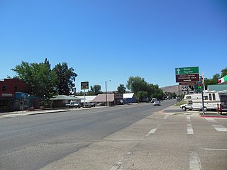
Priest River is a city in Bonner County, Idaho. The population was 1,751 at the 2010 census. Located in the Idaho Panhandle region of the state, the city is at the mouth of the Priest River on the Pend Oreille River.

<span class="mw-page-title-main">Parma, Idaho</span> City in Canyon County, Idaho, United States

Parma is a city in Canyon County, Idaho, United States. The population was 1,983 at the 2010 census, up from 1,771 in 2000. It is the fourth largest city in the county and the largest in the rural western portion. It is part of the Boise City–Nampa, Idaho Metropolitan Statistical Area.

<span class="mw-page-title-main">Grace, Idaho</span> City in Idaho, United States

Grace is a city in Caribou County, Idaho, United States. The population was 915 at the 2010 census.

<span class="mw-page-title-main">Clayton, Idaho</span> City in Idaho, United States

Clayton is a city in Custer County, Idaho, United States. The population was 7 at the 2010 census, down from 27 in 2000. It is adjacent to the Salmon River.

<span class="mw-page-title-main">Drummond, Idaho</span> City in Idaho, United States

Drummond is a city in Fremont County, Idaho, United States. The population was 16 at the 2010 census. It is part of the Rexburg, Idaho Micropolitan Statistical Area.

<span class="mw-page-title-main">Hamer, Idaho</span> City in Idaho, United States

Hamer is a city in Jefferson County, Idaho, United States. It is part of the Idaho Falls Metropolitan Statistical Area. The population was 48 at the 2010 census.

<span class="mw-page-title-main">Eden, Idaho</span> City in Idaho, United States

Eden is a city in Jerome County, Idaho, United States. The population was 405 at the 2010 census. It is part of the Twin Falls, Idaho Metropolitan Statistical Area.

<span class="mw-page-title-main">Jerome, Idaho</span> City in Idaho, United States

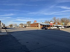
Jerome is a city in and county seat of Jerome County, Idaho, United States. The population was 10,890 at the 2010 census, up from 7,780 in 2000. The city is the county seat of Jerome County, and is part of the Twin Falls Micropolitan Statistical Area. It is the second largest city in Idaho's Magic Valley region, second only to Twin Falls which is located 10 miles (16 km) southeast. Jerome's economy is largely agrarian, with dairy farming being one of the main revenue sources for the local economy.

<span class="mw-page-title-main">Castleford, Idaho</span> City in Idaho, United States

Castleford is a city in Twin Falls County, Idaho, United States. The population was 226 at the 2010 census. It is part of the Twin Falls, Idaho Micropolitan Statistical Area.

<span class="mw-page-title-main">Cambridge, Idaho</span> City in Idaho, United States

Cambridge is a city in Washington County, Idaho, United States. The population was 328 at the 2010 census, down from 360 in 2000. It is the second largest city in the county, behind the significantly larger Weiser, the county seat.

<span class="mw-page-title-main">Orient, Maine</span> Town in the state of Maine, United States

Orient is a town in Aroostook County, Maine, United States. The population was 156 at the 2020 census.

<span class="mw-page-title-main">Lewiston, Utah</span> City in Utah, United States

Lewiston is a city in Cache County, Utah, United States. It is situated at the northern Utah border and borders the state of Idaho. The population was 1,766 at the 2010 census. It is included in the Logan, Utah-Idaho (partial) Metropolitan Statistical Area.

<span class="mw-page-title-main">Adams, Wisconsin</span> City in Wisconsin, United States

Adams is a city in Adams County in the U.S. state of Wisconsin. The population was 1,761 at the 2020 census. The city is located within the Town of Adams.

References

  1. "2019 U.S. Gazetteer Files". United States Census Bureau. Retrieved July 9, 2020.
  2. 1 2 "U.S. Census website". United States Census Bureau . Retrieved December 18, 2012.
  3. "2010 census: Idaho > Hagerman". Spokesman.com. Archived from the original on March 27, 2012. Retrieved December 2, 2012.
  4. Williams-Brackett, Kimberly (November 27, 2012). "Curious mind: irrigation tech, climate cause springs' decline". Twin Falls Times-News. Retrieved December 2, 2012.
  5. Hagerman Fossil Beds: Nature
  6. Fox, Bruce (November 11, 1967). "Park urged at fossil site". Spokane Daily Chronicle. Associated Press. p. 3.
  7. "US Gazetteer files: 2010, 2000, and 1990". United States Census Bureau. February 12, 2011. Retrieved April 23, 2011.
  8. "US Gazetteer files 2010". United States Census Bureau . Retrieved December 18, 2012.
  9. 1 2 "NOAA Online Weather Data – NWS Boise". National Weather Service. Retrieved May 27, 2023.
  10. "U.S. Climate Normals Quick Access – Station: Hagerman 2 SW, ID". National Oceanic and Atmospheric Administration. Retrieved May 27, 2023.
  11. "Census of Population and Housing". Census.gov. Retrieved June 4, 2015.
  12. "U.S. Census website". United States Census Bureau . Retrieved January 31, 2008.
  13. "2020 CENSUS - SCHOOL DISTRICT REFERENCE MAP: Gooding County, ID" (PDF). U.S. Census Bureau . Retrieved March 12, 2024. - Text list
  14. "Community Colleges" (PDF). Legislative Budget Book. Idaho Legislature. 2016. p. 1-81 (PDF p. 3/9). - See area 1 in: "TITLE 33 EDUCATION CHAPTER 21 JUNIOR COLLEGES". Idaho Legislature . Retrieved March 12, 2024.