Homedale,Idaho | |
---|---|
City | |
Coordinates: 43°37′18″N116°56′13″W / 43.62167°N 116.93694°W | |
Country | United States |
State | Idaho |
County | Owyhee |
Area | |
• Total | 1.42 sq mi (3.69 km2) |
• Land | 1.41 sq mi (3.66 km2) |
• Water | 0.01 sq mi (0.03 km2) |
Elevation | 2,241 ft (683 m) |
Population (2010) [3] | |
• Total | 2,633 |
• Density | 1,926.35/sq mi (743.75/km2) |
Time zone | UTC-7 (Mountain (MST)) |
• Summer (DST) | UTC-6 (MDT) |
ZIP code | 83628 |
Area code(s) | 208, 986 |
FIPS code | 16-38170 |
GNIS feature ID | 2410782 [2] |
Website | www |
Homedale is a city in Owyhee County Idaho. The population was 2,633 at the time of the 2010 census. The town name was chosen by drawing names from a hat during a community picnic. Homedale is part of the Boise metropolitan area. It was, at one time, the terminus of a branch of the Oregon Short Line Railroad.
Homedale was first settled by Jacob Mussell in the late 19th century. In 1898 Jacob Mussell built a ferry boat to help settlers cross the Snake River making Homedale more accessible. By 1914 Homedale had a mayor, a council, a schoolhouse, and a railroad though it wouldn't be an official city until 1920. In 1914 Austrians were lured to Homedale and promised good farming ground. When they arrived in Homedale they found the land undeveloped though they still had to buy the land. Today there still is an Austrian Town in Homedale. Basque culture is also deeply rooted in Homedale.
Homedale is on the Snake River, which is the border with Canyon County.
According to the United States Census Bureau, the city has a total area of 1.47 square miles (3.81 km2), all of it land. [4]
Census | Pop. | Note | %± |
---|---|---|---|
1930 | 225 | — | |
1940 | 857 | 280.9% | |
1950 | 1,411 | 64.6% | |
1960 | 1,381 | −2.1% | |
1970 | 1,411 | 2.2% | |
1980 | 2,078 | 47.3% | |
1990 | 1,963 | −5.5% | |
2000 | 2,528 | 28.8% | |
2010 | 2,633 | 4.2% | |
2019 (est.) | 2,720 | [5] | 3.3% |
U.S. Decennial Census [6] |
As of the census [3] of 2010, there were 2,633 people, 877 households, and 609 families living in the city. The population density was 1,791.2 inhabitants per square mile (691.6/km2). There were 960 housing units at an average density of 653.1 per square mile (252.2/km2). The racial makeup of the city was 63.1% White, 0.2% African American, 1.3% Native American, 1.0% Asian, 31.3% from other races, and 3.2% from two or more races. Hispanic or Latino of any race were 43.0% of the population.
There were 877 households, of which 43.9% had children under the age of 18 living with them, 48.2% were married couples living together, 14.3% had a female householder with no husband present, 7.0% had a male householder with no wife present, and 30.6% were non-families. 25.2% of all households were made up of individuals, and 12.9% had someone living alone who was 65 years of age or older. The average household size was 2.96 and the average family size was 3.58.
The median age in the city was 31.9 years. 33.5% of residents were under the age of 18; 8.7% were between the ages of 18 and 24; 25.2% were from 25 to 44; 19% were from 45 to 64; and 13.5% were 65 years of age or older. The gender makeup of the city was 49.9% male and 50.1% female.
As of the census [7] of 2000, there were 2,528 people, 842 households, and 595 families living in the city. The population density was 2,859.5 inhabitants per square mile (1,104.1/km2). There were 933 housing units at an average density of 1,055.3 per square mile (407.5/km2). The racial makeup of the city was 63.77% White, 0.20% African American, 0.99% Native American, 0.71% Asian, 0.08% Pacific Islander, 30.58% from other races, and 3.68% from two or more races. Hispanic or Latino of any race were 39.24% of the population.
There were 842 households, out of which 42.3% had children under the age of 18 living with them, 54.3% were married couples living together, 12.4% had a female householder with no husband present, and 29.3% were non-families. 26.6% of all households were made up of individuals, and 14.7% had someone living alone who was 65 years of age or older. The average household size was 2.95 and the average family size was 3.66.
In the city, the population was spread out, with 36.0% under the age of 18, 8.8% from 18 to 24, 25.0% from 25 to 44, 16.2% from 45 to 64, and 14.0% who were 65 years of age or older. The median age was 29 years. For every 100 females, there were 96.7 males. For every 100 females age 18 and over, there were 92.7 males.
The median income for a household in the city was $24,196, and the median income for a family was $27,500. Males had a median income of $22,740 versus $19,722 for females. The per capita income for the city was $10,986. About 17.8% of families and 20.3% of the population were below the poverty line, including 24.9% of those under age 18 and 13.1% of those age 65 or over.
The city is served by U.S. Route 95, the primary north–south highway for the state. State Highway 19 heads westward for five miles (8 km) and enters Oregon to become Oregon Route 201, which turns northward to Ontario.
According to the Köppen climate classification, Homedale has a cold semi arid climate (BSk).
Climate data for Homedale, Idaho, 1991–2020 normals, extremes 1990–present | |||||||||||||
---|---|---|---|---|---|---|---|---|---|---|---|---|---|
Month | Jan | Feb | Mar | Apr | May | Jun | Jul | Aug | Sep | Oct | Nov | Dec | Year |
Record high °F (°C) | 62 (17) | 69 (21) | 82 (28) | 90 (32) | 100 (38) | 107 (42) | 112 (44) | 109 (43) | 104 (40) | 94 (34) | 82 (28) | 66 (19) | 112 (44) |
Mean maximum °F (°C) | 53.5 (11.9) | 61.0 (16.1) | 71.0 (21.7) | 82.0 (27.8) | 91.3 (32.9) | 98.5 (36.9) | 104.1 (40.1) | 102.8 (39.3) | 95.8 (35.4) | 84.4 (29.1) | 65.7 (18.7) | 56.1 (13.4) | 104.8 (40.4) |
Mean daily maximum °F (°C) | 37.9 (3.3) | 45.7 (7.6) | 56.5 (13.6) | 63.7 (17.6) | 73.0 (22.8) | 81.4 (27.4) | 92.3 (33.5) | 91.1 (32.8) | 80.5 (26.9) | 65.7 (18.7) | 49.5 (9.7) | 38.7 (3.7) | 64.7 (18.1) |
Daily mean °F (°C) | 30.4 (−0.9) | 36.3 (2.4) | 44.3 (6.8) | 50.6 (10.3) | 59.9 (15.5) | 67.0 (19.4) | 75.7 (24.3) | 73.2 (22.9) | 63.3 (17.4) | 50.7 (10.4) | 39.0 (3.9) | 30.9 (−0.6) | 51.8 (11.0) |
Mean daily minimum °F (°C) | 22.9 (−5.1) | 26.8 (−2.9) | 32.0 (0.0) | 37.4 (3.0) | 46.8 (8.2) | 52.7 (11.5) | 59.1 (15.1) | 55.4 (13.0) | 46.0 (7.8) | 35.7 (2.1) | 28.5 (−1.9) | 23.1 (−4.9) | 38.9 (3.8) |
Mean minimum °F (°C) | 6.1 (−14.4) | 12.4 (−10.9) | 17.6 (−8.0) | 22.2 (−5.4) | 31.4 (−0.3) | 39.5 (4.2) | 46.2 (7.9) | 43.1 (6.2) | 33.0 (0.6) | 21.1 (−6.1) | 12.5 (−10.8) | 6.9 (−13.9) | 1.3 (−17.1) |
Record low °F (°C) | −17 (−27) | 3 (−16) | 11 (−12) | 13 (−11) | 22 (−6) | 33 (1) | 35 (2) | 32 (0) | 19 (−7) | 8 (−13) | −3 (−19) | −15 (−26) | −17 (−27) |
Average precipitation inches (mm) | 1.45 (37) | 0.85 (22) | 0.94 (24) | 0.87 (22) | 1.30 (33) | 0.81 (21) | 0.30 (7.6) | 0.22 (5.6) | 0.41 (10) | 0.75 (19) | 0.98 (25) | 1.18 (30) | 10.06 (256.2) |
Average precipitation days (≥ 0.01 in) | 6.1 | 4.0 | 5.0 | 6.2 | 4.3 | 4.4 | 1.1 | 1.3 | 1.1 | 3.8 | 4.7 | 5.3 | 47.3 |
Source 1: NOAA [8] | |||||||||||||
Source 2: National Weather Service [9] |
Elko County is a county in the northeastern corner of Nevada, United States. As of the 2020 census, the population was 53,702. Its county seat is Elko. The county was established on March 5, 1869, from Lander County. Elko County is the fourth-largest county by area in the contiguous United States, ranking lower when the boroughs of Alaska are included. It is one of only 10 counties in the U.S. with more than 10,000 square miles (25,900 km2) of area. Elko County is the second-largest county by area in Nevada, with only Nye County being larger. Elko County is part of the Elko micropolitan statistical area. It contains 49.8 percent of the Duck Valley Indian Reservation, set up in the late 19th century for the Shoshone-Paiute peoples; they are a federally recognized tribe. Although slightly more than 50% of the reservation is across the border in Owyhee County, Idaho, the majority of tribal members live on the Nevada side. The reservation's land area is 450.391 square miles (1,166.5 km2).
Twin Falls County is a county in the south central part of the U.S. state of Idaho. As of the 2020 census, the population was 90,046, making it the fifth-most populous county in Idaho. The county seat and largest city is Twin Falls. Twin Falls County is part of the Twin Falls, ID Twin Falls Metropolitan Statistical Area.
Owyhee County is a county in the southwestern corner of the U.S. state of Idaho. As of the 2020 census, the population was 11,913. The county seat is Murphy, and its largest city is Homedale. In area it is the second-largest county in Idaho, behind Idaho County. Owyhee County is part of the Boise metropolitan area and contains slightly more than half of the Duck Valley Indian Reservation, which extends over the Nevada border, into Elko County. The majority of the federally recognized Shoshone-Paiute Tribe that is associated with this reservation lives on the Nevada side; its tribal center is in Owyhee, Nevada.
Elmore County is a county in the U.S. state of Idaho. As of the 2020 census, the population was 28,666. The largest city and county seat is Mountain Home.
Canyon County is located in the U.S. state of Idaho. As of the 2020 Census, the population was 231,105, which by 2022 was estimated to have risen to 251,065. making it the second-most populous county in Idaho. The county seat is Caldwell, and its largest city is Nampa. Canyon County is part of the Boise metropolitan area.
Eagle is a city in Ada County, Idaho, ten miles (16 km) northwest of downtown Boise. The population was 30,346 at the 2020 census.
Dover is a city in Bonner County, Idaho. The population was 556 at the 2010 census.
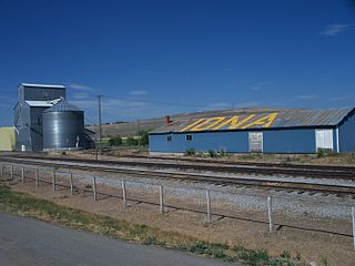
Iona is a city in Bonneville County, Idaho, United States. It is part of the Idaho Falls, Idaho Metropolitan Statistical Area. The population was 1,803 at the 2010 census.
Swan Valley is a city in Bonneville County, Idaho, United States. It is part of the Idaho Falls, Idaho Metropolitan Statistical Area. The population was 204 at the 2010 census.
Wilder is a city in Canyon County, Idaho, United States. The population was 1,533 at the 2010 census.
Bancroft is a city in the Gem Valley in Caribou County, Idaho, United States. The population was 299 at the 2020 census, and 377 at the 2010 census.
Weston is a city in Franklin County, Idaho, United States. The population was 511 at the 2020 census. It is part of the Logan, Utah-Idaho Metropolitan Statistical Area. It was first settled in 1865. The community was so named due to its location at the west bank of the Bear River.
Jerome is a city in and county seat of Jerome County, Idaho, United States. The population was 10,890 at the 2010 census, up from 7,780 in 2000. The city is the county seat of Jerome County, and is part of the Twin Falls Micropolitan Statistical Area. It is the second largest city in Idaho's Magic Valley region, second only to Twin Falls which is located 10 miles (16 km) southeast. Jerome's economy is largely agrarian, with dairy farming being one of the main revenue sources for the local economy.
Acequia is a city in Minidoka County, Idaho, United States. The population was 131 at the 2020 census. It is part of the Burley, Idaho Micropolitan Statistical Area. The town is named for the Spanish word for canal.
Grand View is a city along the Snake River in Owyhee County, Idaho, United States. The population was 440 at the 2020 census. It is part of the Boise City–Nampa, Idaho Metropolitan Statistical Area.
Marsing is a city in Owyhee County, Idaho, United States. The population was 1,031 at the time of the 2010 census. It is part of the Boise metropolitan area.
Fruitland is a city along the Snake and Payette rivers in Payette County, Idaho, United States. It lies along U.S. Route 95 in the Treasure Valley of southwest Idaho, about 50 miles (80 km) west of Boise on the border with Oregon. It is part of the Ontario Micropolitan Area. Fruitland is named after apple orchards that surround the community, and its slogan is "The Big Apple of Idaho."
Hansen is a city in Twin Falls County, Idaho, United States. The population was 1,086 at the 2020 census, and 1,144 at the 2010 census. It is part of the Twin Falls, Idaho Micropolitan Statistical Area.
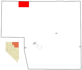
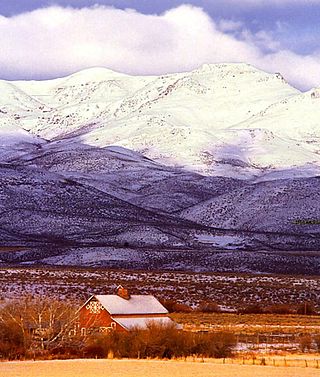
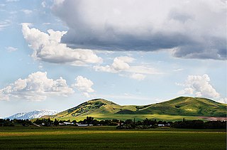
Owyhee is a census-designated place (CDP) in Elko County, Nevada, United States, along the banks of the Owyhee River. The population was 953 at the 2010 census. It is part of the Elko Micropolitan Statistical Area. It is the primary town of the federally recognized Shoshone-Paiute tribe's Duck Valley Indian Reservation, which covers portions of northern Nevada and southern Idaho, and the majority of its population are Native American.
Adrian is a city in Malheur County, Oregon, United States, near the confluence of the Snake River and the Owyhee River. The population was 177 at the 2010 census. It is part of the Ontario, OR–ID Micropolitan Statistical Area.
Media related to Homedale, Idaho at Wikimedia Commons