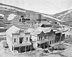
The Superintendent's Residence (left) and Hotel Dewey, 1898
The town was settled in 1863 and named "Booneville", after its first inhabitant, Captain Boone.[1][2] Booneville was at first very prosperous, but then fell into decay.[2]
In 1896, the property at Booneville and its hotel were purchased by Colonel W.H. Dewey, superintendent of the Florida Mountain Mining Company. Dewey's company erected a mill, and a mine was located nearby.[2][3] The town had a butcher shop, general store, steam laundry, livery stable and barn, and a large hotel, the Hotel Dewey. "Nothing had been neglected in the way of making the town complete as to conveniences for its inhabitants".[2]:69
A post office was established in 1897, and was named "Dewey".[2]
Within a few years, there was a decline in mining, and the hotel had burned down. The town was soon abandoned.[3]
All that remains of Dewey is a large cement powerplant building, and the mine dump.[3]
This page is based on this Wikipedia article Text is available under the CC BY-SA 4.0 license; additional terms may apply. Images, videos and audio are available under their respective licenses.