Melba, Idaho

Last updated

Melba, Idaho
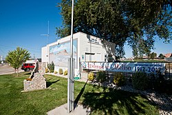
Melba city hall melba idaho 2012-10-01.jpg
Melba City Hall in Melba Idaho
Motto: 
"Seed Heart of America" [1]
Canyon County Idaho Incorporated and Unincorporated areas Melba Highlighted 1651850.svg
Location of Melba in Canyon County, Idaho.
Coordinates: 43°22′25″N116°31′45″W / 43.37361°N 116.52917°W / 43.37361; -116.52917
Country United States
State Idaho
County Canyon
Area
[2]
  Total0.41 sq mi (1.05 km2)
  Land0.40 sq mi (1.04 km2)
  Water0.01 sq mi (0.02 km2)
Elevation
2,667 ft (813 m)
Population
 (2010) [3]
  Total513
  Estimate 
(2019) [4]
558
  Density1,395.00/sq mi (538.93/km2)
Time zone UTC-7 (Mountain (MST))
  Summer (DST) UTC-6 (MDT)
ZIP code
83641
Area code 208
FIPS code 16-51850
GNIS feature ID0396878
Website www.cityofmelba.org
Historical population
CensusPop.Note
1940 213
1950 203−4.7%
1960 197−3.0%
1970 1970.0%
1980 27640.1%
1990 252−8.7%
2000 43974.2%
2010 51316.9%
2019 (est.)558 [4] 8.8%
U.S. Decennial Census [5]

Melba is a village in Canyon County, Idaho. The population was 513 at the time of the 2010 census, up from 439 in 2000. It is part of the Boise metropolitan area.

Contents

History

Melba was founded in 1912 by Clayton C. Todd, who named it after his daughter. [6]

Geography

Melba is located at 43°22′25″N116°31′45″W / 43.37361°N 116.52917°W / 43.37361; -116.52917 (43.373487, -116.529194). [7] at an elevation of 2,667 feet (813 m) above sea level. It is 12 miles (19 km) south of Nampa, and three miles (5 km) northeast of the Snake River.

According to the United States Census Bureau, the village has a total area of 0.40 square miles (1.04 km2), of which, 0.39 square miles (1.01 km2) is land and 0.01 square miles (0.03 km2) is water. [8]

Demographics

2010 census

At the 2010 census there were 513 people in 171 households, including 133 families, in the village. The population density was 1,315.4 inhabitants per square mile (507.9/km2). There were 197 housing units at an average density of 505.1 per square mile (195.0/km2). The racial makeup of the village was 78.9% White, 0.2% African American, 0.2% Asian, 17.7% from other races, and 2.9% from two or more races. Hispanic or Latino of any race were 24.6%. [3]

Of the 171 households 45.0% had children under the age of 18 living with them, 57.9% were married couples living together, 15.2% had a female householder with no husband present, 4.7% had a male householder with no wife present, and 22.2% were non-families. 21.1% of households were one person and 11.1% were one person aged 65 or older. The average household size was 3.00 and the average family size was 3.38.

The median age was 32.8 years. 33.5% of residents were under the age of 18; 7.3% were between the ages of 18 and 24; 27.9% were from 25 to 44; 21.2% were from 45 to 64; and 10.3% were 65 or older. The gender makeup of the village was 53.2% male and 46.8% female.

2000 census

At the 2000 census there were 439 people in 156 households, including 105 families, in the village. The population density was 1,481.5 inhabitants per square mile (572.0/km2). There were 164 housing units at an average density of 553.4 per square mile (213.7/km2). The racial makup of the village was 84.28% White, 0.46% Native American, 0.23% Asian, 13.67% from other races, and 1.37% from two or more races. Hispanic or Latino of any race were 14.58%. [9]

Of the 156 households 38.5% had children under the age of 18 living with them, 52.6% were married couples living together, 7.7% had a female householder with no husband present, and 32.1% were non-families. 27.6% of households were one person and 14.7% were one person aged 65 or older. The average household size was 2.81 and the average family size was 3.37.

The age distribution was 32.8% under the age of 18, 10.5% from 18 to 24, 28.9% from 25 to 44, 15.7% from 45 to 64, and 12.1% 65 or older. The median age was 30 years. For every 100 females, there were 118.4 males. For every 100 females age 18 and over, there were 113.8 males.

The median household income was $31,429 and the median family income was $40,000. Males had a median income of $25,096 versus $20,750 for females. The per capita income for the village was $12,928. About 9.6% of families and 13.8% of the population were below the poverty line, including 10.4% of those under age 18 and 9.6% of those age 65 or over.
Notable people

Related Research Articles

<span class="mw-page-title-main">Pine Valley, California</span> Census-designated place in California, United States

Pine Valley is a community and census-designated place (CDP) in the Cuyamaca Mountains of the Mountain Empire area, in southeastern San Diego County, California. The population was 1,510 at the 2010 census, up from 1,501 at the 2000 census.

<span class="mw-page-title-main">Garden City, Idaho</span> City in Idaho, United States

Garden City is a city in Ada County, Idaho. The population was 12,316 at the time of the 2020 census. Garden City is nearly surrounded by Boise but retains a separate municipal government.

<span class="mw-page-title-main">Dover, Idaho</span> City in Idaho, United States

Dover is a city in Bonner County, Idaho. The population was 556 at the 2010 census.

<span class="mw-page-title-main">Ponderay, Idaho</span> City in Idaho, United States

Ponderay is a city in Bonner County, Idaho. The population was 1,137 at the 2010 census, up from 638 in 2000. Ponderay's city motto is "Little City with the Big Future". Its name is an English phonetic spelling of the French words “Pend Oreille”, the name of the lake the city sits upon.

<span class="mw-page-title-main">Priest River, Idaho</span> City in Idaho, United States

Priest River is a city in Bonner County, Idaho. The population was 1,751 at the 2010 census. Located in the Idaho Panhandle region of the state, the city is at the mouth of the Priest River on the Pend Oreille River.

<span class="mw-page-title-main">Greenleaf, Idaho</span> City in Idaho, United States

Greenleaf is a city in Canyon County, Idaho, United States. The population was 846 at the 2010 census. Greenleaf is part of the Boise-Nampa metropolitan area. The town was established by Quakers in the early-1900s and is named after Quaker poet and abolitionist John Greenleaf Whittier.

<span class="mw-page-title-main">Wilder, Idaho</span> City in Idaho, United States

Wilder is a city in Canyon County, Idaho, United States. The population was 1,533 at the 2010 census.

<span class="mw-page-title-main">Dalton Gardens, Idaho</span> City in Kootenai County, Idaho, United States

Dalton Gardens is a city in Kootenai County, Idaho, United States. It is considered a suburb of Coeur d'Alene and borders the city to the north and east. The city of Dalton Gardens is also part of the larger Spokane-Coeur d'Alene Combined Metropolitan Statistical Area which encompasses Kootenai County, Idaho. The population of Dalton Gardens was 2,335 at the time of the 2010 census.

<span class="mw-page-title-main">Fernan Lake Village, Idaho</span> City in Idaho, United States

Fernan Lake Village is a city in Kootenai County, Idaho, United States. The population was 169 at the 2010 census.

<span class="mw-page-title-main">Worley, Idaho</span> City in Idaho, United States

Worley is a city in southwestern Kootenai County, Idaho, United States. The population was 257 at the 2010 census, up from 223 in 2000. The city is within the Coeur d'Alene Indian Reservation.

<span class="mw-page-title-main">Culdesac, Idaho</span> City in Idaho, United States

Culdesac is a city in Nez Perce County, Idaho, United States. The population was 380 at the 2010 census. It is part of the Lewiston, ID-WA Metropolitan Statistical Area.

<span class="mw-page-title-main">Grand View, Idaho</span> City in Owyhee County, Idaho, United States

Grand View is a city along the Snake River in Owyhee County, Idaho, United States. The population was 452 at the 2010 census. It is part of the Boise City–Nampa, Idaho Metropolitan Statistical Area.

<span class="mw-page-title-main">Marsing, Idaho</span> City in Owhyee County, Idaho, United States

Marsing is a city in Owyhee County, Idaho, United States. The population was 1,031 at the time of the 2010 census. It is part of the Boise metropolitan area.

<span class="mw-page-title-main">Fruitland, Idaho</span> City in Payette County, Idaho, United States

Fruitland is a city along the Snake and Payette rivers in Payette County, Idaho, United States. It lies along U.S. Route 95 in the Treasure Valley of southwest Idaho, about 50 miles (80 km) west of Boise on the border with Oregon. It is part of the Ontario Micropolitan Area. Fruitland is named after apple orchards that surround the community, and its slogan is "The Big Apple of Idaho."

<span class="mw-page-title-main">Osburn, Idaho</span> City in Shoshone County, Idaho, United States

Osburn is a city in Shoshone County, Idaho, United States. Located in the Silver Valley mining region of northern Idaho, its population was 1,555 at the 2010 census.

<span class="mw-page-title-main">Donnelly, Idaho</span> City in Idaho, United States

Donnelly is a city in rural Valley County, Idaho, United States. The population was 152 at the 2010 census.

<span class="mw-page-title-main">Hammond, Minnesota</span> City in Minnesota, United States

Hammond is a city in Wabasha County, Minnesota, United States. The population was 132 at the 2010 census.

<span class="mw-page-title-main">Emerald Beach, Missouri</span> Village in Missouri, United States

Emerald Beach is a village in White River Township, Barry County, Missouri, United States. The community is located on a bend in the White River now Table Rock Lake. Cassville is approximately 13 miles to the northwest and Rogers, Arkansas is 32 mile to the southwest.

<span class="mw-page-title-main">Kekoskee, Wisconsin</span> Village in Wisconsin, United States

Kekoskee is a village in Dodge County, Wisconsin, United States. The population was 161 at the 2010 census.

<span class="mw-page-title-main">Hollandale, Wisconsin</span> Village in Wisconsin, United States

Hollandale is a village in Iowa County, Wisconsin, United States. The population was 306 at the 2020 census. It is part of the Madison Metropolitan Statistical Area.

References

  1. "City of Melba, Idaho". City of Melba, Idaho. Retrieved September 2, 2012.
  2. "2019 U.S. Gazetteer Files". United States Census Bureau. Retrieved July 9, 2020.
  3. 1 2 "U.S. Census website". United States Census Bureau . Retrieved December 18, 2012.
  4. 1 2 "Population and Housing Unit Estimates". United States Census Bureau. May 24, 2020. Retrieved May 27, 2020.
  5. "Census of Population and Housing". Census.gov. Retrieved June 4, 2015.
  6. cityofmelba.org Archived 2016-03-04 at the Wayback Machine - history - accessed 2011-12-13
  7. "US Gazetteer files: 2010, 2000, and 1990". United States Census Bureau. February 12, 2011. Retrieved April 23, 2011.
  8. "US Gazetteer files 2010". United States Census Bureau. Archived from the original on January 25, 2012. Retrieved December 18, 2012.
  9. "U.S. Census website". United States Census Bureau . Retrieved January 31, 2008.