
Idaho is a landlocked state in the Pacific Northwest and Mountain West subregions of the Western United States. It borders Montana and Wyoming to the east, Nevada and Utah to the south, and Washington and Oregon to the west; the state shares a small portion of the Canada–United States border to the north with the Canadian province of British Columbia. Idaho's state capital and largest city is Boise. With an area of 83,569 square miles (216,440 km2), Idaho is the 14th-largest state by land area. The state has a population of approximately 2 million people; it ranks as the 13th-least populous and the seventh-least densely populated of the 50 U.S. states.

Boise is the capital and most populous city in the U.S. state of Idaho and is the county seat of Ada County. As of the 2020 census, there were 235,684 people residing in the city. On the Boise River in southwestern Idaho, it is 41 miles (66 km) east of the Oregon border and 110 miles (177 km) north of the Nevada border. The downtown area's elevation is 2,704 feet (824 m) above sea level.
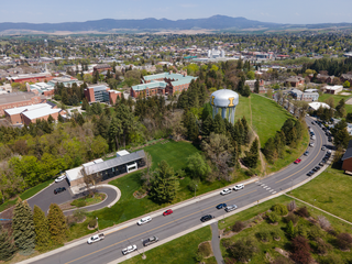
Moscow is a city and the county seat of Latah County, Idaho. Located in the North Central region of the state along the border with Washington, it had a population of 25,435 at the 2020 census. Moscow is the home of the University of Idaho, the state's land-grant institution and primary research university.

Canyon County is located in the U.S. state of Idaho. As of the 2020 Census, the population was 231,105, which by 2022 was estimated to have risen to 251,065. making it the second-most populous county in Idaho. The county seat is Caldwell, and its largest city is Nampa. Canyon County is part of the Boise metropolitan area.

Pocatello is the county seat and largest city of Bannock County, with a small portion on the Fort Hall Indian Reservation in neighboring Power County, containing the city's airport. It is the principal city of the Pocatello metropolitan area, which encompasses all of Bannock County in the southeastern part of the U.S. state of Idaho.
Burley is a city in Cassia and Minidoka counties in southern Idaho, United States. The population was 11,704 at the 2020 census, up from 10,345 in 2010. The city is the county seat of Cassia County.

Sunnyslope is an unincorporated community and census-designated place (CDP) in Chelan County, Washington, United States. It is part of the Wenatchee–East Wenatchee Metropolitan Statistical Area. The population was 4,041 at the 2020 census, up from 3,252 at the 2010 census.
The Inland Northwest, historically and alternatively known as the Inland Empire, is a region of the American Northwest centered on the Greater Spokane, Washington Area, encompassing all of Eastern Washington and North Idaho. Under broader definitions, Northeastern Oregon and Western Montana may be included in the Inland Northwest. Alternatively, stricter definitions may exclude Central Washington and Idaho County, Idaho.

The Boise, Idaho Metropolitan Statistical Area (MSA) is an area that encompasses Ada, Boise, Canyon, Gem, and Owyhee counties in southwestern Idaho, anchored by the cities of Boise and Nampa. It is the main component of the wider Boise–Mountain Home–Ontario, ID–OR Combined Statistical Area, which adds Elmore and Payette counties in Idaho and Malheur County, Oregon. It is the state's largest officially designated metropolitan area and includes Idaho's three largest cities: Boise, Nampa, and Meridian. Nearly 40 percent of Idaho's total population lives in the area.

The Nez Perce (Nee-Me-Poo) National Historic Trail follows the route taken by a large group of people of the Nez Perce tribe in 1877 to avoid being forced onto a reservation. The 1,170-mile (1,883 km) trail was created in 1986 as part of the National Trails System Act and is managed by the U.S. Forest Service. The trail passes through portions of the U.S. states of Oregon, Idaho, Wyoming, and Montana. It connects sites across these states to commemorate significant events of the Nez Perce War, which took place between June and October 1877 as several bands of Nez Perce tried to evade the U.S. Cavalry and escape to Canada. The sites are among the 38 that are collectively managed by the U.S. National Park Service as part of the Nez Perce National Historical Park, though some sites are individually managed by local or state-affiliated organizations.

Sunnyslope Mountain also known as "S" Mountain is a large, rocky, nearly symmetric hill in the Sunnyslope section of Phoenix, Arizona. It is located near Central Avenue and Hatcher Road. The southern slope of the mountain is adorned with a 150-foot white majuscule "S". The mountain, in particular the large "S", can be seen from thirty miles away on a clear day, and is distinctly visible to nearby airplane passengers. Although the mountain is part of the Phoenix Mountains, the mountain is most closely associated with Sunnyslope High School. Each year, the freshmen class is assigned the task of hiking up the mountain and giving the "S" a fresh coat of white paint. At the end of the Homecoming football game, the "S" is traditionally outlined with red flares which are ignited by members of the freshmen football team. Students came together in June 2004 to convert the "S" to a "J" in memory of Josh Conard, a basketball player for Sunnyslope who was killed by a drunk driver. When the school was remodeled in the mid-1990s, the view of Sunnyslope Mountain from the home football stands was partially obstructed. However, Sunnyslope Mountain remains one of the most visible, artificial features of the northern skyline of the Valley of the Sun.

U.S. Route 2 (US 2) is a component of the United States Numbered Highway System that connects the city of Everett in the U.S. state of Washington to the Upper Peninsula of Michigan, with a separate segment that runs from Rouses Point, New York, to Houlton, Maine. Within Washington, the highway travels on a 326-mile-long (525 km) route that connects the western and eastern regions of the state as a part of the state highway system and the National Highway System. US 2 forms parts of two National Scenic Byways, the Stevens Pass Greenway from Monroe to Cashmere and the Coulee Corridor Scenic Byway near Coulee City, and an All-American Road named the International Selkirk Loop within Newport.

The Spokane River Centennial Trail is a 37-mile (60 km) paved trail in Eastern Washington for alternate transportation and recreational use. It is managed by Washington State Parks as the Centennial Trail State Park.

North Fork is an unincorporated community in Lemhi County, Idaho. Its name is derived from confluence of the south-flowing North Fork of the Salmon River with the north-flowing main Salmon River, which makes a near-right angle turn here to flow westward across the state to Riggins. US 93 serves the community, connecting it with Salmon to the south and Lost Trail Pass to the north.
Sunnyslope is an unincorporated community in Butte County, California, United States.
Wenatchee Confluence State Park is a public recreation area and nature preserve at the north end of the city of Wenatchee in Chelan County, Washington. The state park consists of 197 acres (80 ha) spanning the Wenatchee River at its confluence with the Columbia River. The park is bifurcated by the Wenatchee River into north and south sections that are connected by a footbridge. The north section, located in Sunnyslope, is suburban and recreational while the south section, located in West Wenatchee, is a man-made wetland area designated as the Horan Natural Area. The park is operated by the Washington State Parks and Recreation Commission under lease from the Chelan County Public Utility District, which owns the land. Park offerings include camping, boating, fishing, swimming, and various sports activities.

The Sunnyslope community is an established neighborhood within the borders of the city of Phoenix, Arizona. The geographic boundaries are 19th Avenue to the west, Cactus Road to the north, 16th Street to the east, and Northern Avenue to the south. This area covers approximately nine square miles (23 km2) and is divided into nine census tracts. The Sunnyslope community is included in parts of three zip code areas: 85020, 85021 and 85029.

El Cid Castle was a landmark structure located on the opposite side of the western boundary of Sunnyslope, Arizona. The controversial castle, built by the late Dr. Kenneth Hall, was supposed to be a bowling alley which resembled a Moorish Castle. Construction on the structure began in 1963 and was completed in 1980.

U.S. Highway 20 (US 20) is the portion of an east–west United States Numbered Highway in the state of Idaho. It begins northwest of Parma at the Oregon state line and enters Montana 9.6 miles (15.4 km) away from the Yellowstone National Park west entrance.


