Fremont, Oregon

Last updated

Fremont, Oregon
Fremont, Oregon, 1915.jpg
Fremont, Oregon in 1915
USA Oregon location map.svg
Red pog.svg
Fremont
Location in Lake County and Oregon
Usa edcp location map.svg
Red pog.svg
Fremont
Fremont (the United States)
Coordinates: 43°22′42″N121°09′12″W / 43.37833°N 121.15333°W / 43.37833; -121.15333
CountryUnited States
State Oregon
County Lake
Established1908
Abandoned1922
Elevation
4,436 ft (1,352 m)
Population
  Total0
Time zone UTC-8 (Pacific)
  Summer (DST) UTC-7 (Pacific)

Fremont was an unincorporated community located in Lake County, Oregon, United States. The first homesteaders arrived in the area around Fremont in 1905. The population grew quickly, and the Fremont post office was opened in 1908. By 1915, the local population was declining rapidly due to a severe drought that dried up surface water and lowered the water table in the area around Fremont. Today, Fremont is a ghost town with no population and no surviving structures. The site is located approximately 5 miles (8.0 km) west of Fort Rock state park. The nearest inhabited place is the small unincorporated community of Fort Rock, Oregon, which is 6 miles (9.7 km) southeast of the Fremont townsite.

Contents

Geography and environment

The Fremont townsite is in the Fort Rock Valley, in the northwest corner of Lake County, Oregon. The townsite is in Oregon's remote high desert country. The elevation at the site is 4,436 feet (1,352 m) above sea level. Today, the site is located on an unimproved dirt road 5 miles (8.0 km) west of Fort Rock state park. [1] [2] [3]

The town of Fremont was built near several well-known geographic landmarks. To the east, Fort Rock rises well above the surrounding high desert plain with a topographic prominence of approximately 325 feet (99 m). Between Fremont and Fort Rock is a small rock outcropping known as Reub Long Butte. Fort Rock Cave is located at the base of this small rocky butte. In 1938, University of Oregon professor Luther S. Cressman excavated the cave and found sandals, tools, and other human artifacts. Carbon dating showed these artifacts were over 9,000 years old. [4] [5] [6]

Fort Rock 5 miles (8.0 km) east of Fremont Fortrock1.jpg
Fort Rock 5 miles (8.0 km) east of Fremont

Another important geographic landmark near the Fremont town site is Hole-in-the-Ground. Fremont is just 2 miles (3.2 km) southeast of the Hole-in-the-Ground crater. Hole-in-the-Ground is a deep volcanic maar created by a series of eruptions followed by ground subsidence in the fractured area. The crater is approximately 4,500 feet (1,400 m) wide east to west and 5,500 feet (1,700 m) across north to south. The rim of the crater is 4,650 feet (1,420 m) above sea level and the elevation at the bottom is 4,340 feet (1,320 m). When Fremont was an active town, Hole-in-the-Ground was known as one of the seven wonders of Central Oregon. [6] [7] [8]

While a federal government report published in 1906 stated that the Fort Rock Valley received 10 to 20 inches (25 to 51 cm) of rain per year, that was not a realistic estimate of the area's normal precipitation. The weather in the Fort Rock Valley around Fremont is dry and hot in the summer and cold and windswept in the winter. Actual weather records show that precipitation in the Fremont area averages only 8.6 inches (22 cm) per year. The average temperature in January is only 25 °F (−4 °C) with a record low of −34 °F (−37 °C). While summer days often exceed 100 °F (38 °C) and the area's record high is 109 °F (43 °C), there is a risk of frost year-round, so the growing season in the Fremont area is short and unpredictable. As a result of the arid climate, vegetation is sparse, consisting mainly of drought-tolerant sagebrush and native bunch grass. [2] [9] [10]

Community history

The first homesteaders arrived in the Fort Rock Valley around 1905. The town of Fremont was established in 1908 at the north end of the valley. The town was named in honor of Captain John C. Fremont, who explored parts of Central Oregon in 1843. [1] [2] [11] [12] Between 1908 and 1915 the Bend Bulletin and other Central Oregon newspapers published numerous articles highlighting the opportunities for dryland farming in the Fort Rock Valley. [10]

The founding of Fremont is attributed to I. R. Fox, who arrived from southern California in 1908. [13] [14] The Fremont post office was opened that same year. [1] By 1910, Fremont was a thriving community. [15] For the next five years, Fremont was a busy commercial center with a post office, school, stores, hotel, creamery, cheese factory, blacksmith shop, and livery stable. The town had a dance hall, library society, band, and a baseball team. During this period, stagecoaches stopped at Fremont daily. On the Fourth of July and other major holidays, people from the local area gathered for community picnics, often at nearby Derrick Cave. The community also hosted dances, horse races, public book readings, baseball games, and band concerts. [11] [13] [16] [17]

The number of new settlers increased dramatically after the United States Congress passed the Homestead Act of 1909. It allowed settlers to claim 320 acres (130 ha) of government land in Central Oregon and parts of other western states. Commercial advertisements extolled the Fort Rock Valley as having rich loam soil capable of growing bumper crops of wheat as well as apples, cherries, pears, plums, prunes, and berries without the need for irrigation. Those advertisements were not truthful; nevertheless, they drew many families to the Fort Rock Valley. [18] [19] When homesteaders arrived, Fremont land locators would for a fee help the new arrivals locate their property in the Fort Rock Valley's featureless sagebrush steppe. [10] [20]

As Fremont grew, new infrastructure was required to support the area's budding economy. In 1909, a new road was built to connect Fremont with the main north–south stage road, now Oregon Route 31. [21] By 1912, the local stage line was transporting settlers from the railhead in Bend to Fremont on a daily scheduled basis. Additional wagon loads of new arrivals often accompanied to stage. [22] At the same time, the Oregon Eastern Railroad was planned to connect to Fremont, but that line was never built. [23]

Even with the new transportation infrastructure connecting Fremont with the rest of the world, local roads were generally very bad, making supplies difficult to obtain in a timely manner. This was a problem for both Fremont's businessmen and local farmers. For example, there is a record of a 1914 purchase of rye seed bought in Burns, Oregon, 120 miles (190 km) northeast of the Fort Rock Valley. instead of shipping the seed by freight wagon cross-country to the Fort Rock Valley, it was sent by mail wagon along the regular mail route north from Burns to Prairie City, Oregon and from there on the Sumpter narrow-gauge railroad east to Baker City, Oregon. It was then sent 350 miles (560 km) west to Portland, Oregon. From there it was shipped by steamer south to San Francisco and then by rail to Reno, Nevada where it was forwarded to Lakeview, Oregon on the newly built Nevada-California-Oregon Railway. Finally, the seed was sent by stagecoach 120 miles (190 km) north from Lakeview to the Fort Rock Valley. In that case, the seed traveled over 1,600 miles (2,600 km) to get to the Fort Rock Valley farmer who ordered it. [13] [24]

Between 1908 and 1914, farm production in the Fort Rock Valley was good due to unusually abundant rainfall. Farms produced wheat, rye, turnips, and rutabagas while local dairy farms supported a creamery and a cheese factory in Fremont. However, a drought began in 1915. By 1917, the drought was acute with only 4.5 inches (11 cm) of precipitation that year. Surface water dried up throughout the Fort Rock Valley while the water table that feed local wells produced barely enough water for farm families' personal use. As a result, farm production declined dramatically and livestock was sold or died. [12] [13] [25]

Ghost town

The drought continued through 1919 and then into the 1920s. This forced homesteaders to abandon their farms and the town of Fremont quickly followed. The Fremont post office closed in 1919. [1] [25] [26] The creamery and cheese factory both closed sometime between 1919 and 1920. [27] By 1921, the town was reduced to one or two stores, a blacksmith shop, and a stage stop station. [28] The last resident left Fremont sometime in the early 1920s. In 1923, a traveler reported that the town of Fremont was deserted. [29] By 1930, Fremont was completely abandoned with virtually no evidence of the town remaining at the site. [30]

Fremont is now a ghost town with no population and no surviving structures. The site has only one remaining artifact, a juniper stump notched with steps. The stair-step stump was originally used by women travelers to mount buggies and horses in a modest fashion. [12] [15] Today, the nearest inhabited place is the small unincorporated community of Fort Rock, Oregon, which is located 6 miles (9.7 km) southeast of the Fremont townsite. [3]

Climate

Climate data for Fremont, Oregon, 1981–2010 normals, 1909–1996 extremes: 4609ft (1405m)
MonthJanFebMarAprMayJunJulAugSepOctNovDecYear
Record high °F (°C)66
(19)
69
(21)
79
(26)
84
(29)
94
(34)
101
(38)
109
(43)
102
(39)
102
(39)
88
(31)
74
(23)
66
(19)
109
(43)
Mean maximum °F (°C)52.3
(11.3)
56.0
(13.3)
64.9
(18.3)
74.3
(23.5)
83.6
(28.7)
90.5
(32.5)
96.3
(35.7)
94.8
(34.9)
89.5
(31.9)
80.0
(26.7)
63.1
(17.3)
53.3
(11.8)
96.7
(35.9)
Mean daily maximum °F (°C)39.3
(4.1)
43.0
(6.1)
51.3
(10.7)
56.7
(13.7)
67.4
(19.7)
75.6
(24.2)
83.9
(28.8)
84.9
(29.4)
75.3
(24.1)
62.9
(17.2)
45.2
(7.3)
37.3
(2.9)
60.2
(15.7)
Daily mean °F (°C)26.2
(−3.2)
28.7
(−1.8)
35.1
(1.7)
39.5
(4.2)
47.1
(8.4)
53.6
(12.0)
59.4
(15.2)
59.0
(15.0)
51.0
(10.6)
41.0
(5.0)
30.2
(−1.0)
24.0
(−4.4)
41.2
(5.1)
Mean daily minimum °F (°C)13.1
(−10.5)
14.3
(−9.8)
19.0
(−7.2)
22.3
(−5.4)
26.8
(−2.9)
31.5
(−0.3)
34.9
(1.6)
33.0
(0.6)
26.6
(−3.0)
19.2
(−7.1)
15.1
(−9.4)
10.8
(−11.8)
22.2
(−5.4)
Mean minimum °F (°C)−10.8
(−23.8)
−3.4
(−19.7)
3.9
(−15.6)
8.9
(−12.8)
14.0
(−10.0)
20.4
(−6.4)
24.5
(−4.2)
23.0
(−5.0)
14.2
(−9.9)
7.9
(−13.4)
−0.9
(−18.3)
−9.3
(−22.9)
−16.4
(−26.9)
Record low °F (°C)−34
(−37)
−39
(−39)
−30
(−34)
0
(−18)
4
(−16)
10
(−12)
14
(−10)
14
(−10)
2
(−17)
−9
(−23)
−29
(−34)
−42
(−41)
−42
(−41)
Average precipitation inches (mm)1.40
(36)
0.92
(23)
0.91
(23)
0.65
(17)
0.88
(22)
0.94
(24)
0.46
(12)
0.42
(11)
0.46
(12)
0.69
(18)
1.27
(32)
1.54
(39)
10.54
(269)
Average snowfall inches (cm)11.4
(29)
7.5
(19)
5.3
(13)
2.1
(5.3)
0.7
(1.8)
0.0
(0.0)
0.0
(0.0)
0.0
(0.0)
0.0
(0.0)
0.6
(1.5)
4.3
(11)
9.8
(25)
41.8
(106)
Source 1: NOAA (XMACIS extremes) [31] [32]
Source 2: WRCC (precipitation & snowfall) [33]

Related Research Articles

<span class="mw-page-title-main">Lake County, Oregon</span> County in Oregon, United States

Lake County is one of the 36 counties in the U.S. state of Oregon. As of the 2020 census, the population was 8,160. Its county seat is Lakeview. The county is named after the many lakes found within its boundaries, including Lake Abert, Summer Lake, Hart Lake, and Goose Lake.

<span class="mw-page-title-main">Lakeview, Oregon</span> Town in Oregon, United States

Lakeview is a town in Lake County, Oregon, United States. The population was 2,418 at the 2020 census. It is the county seat of Lake County. The city bills itself as the "Tallest Town in Oregon" because of its elevation, 4,757 feet (1,450 m) above sea level. Lakeview is situated in the Goose Lake Valley at the foot of the Warner Mountains and at the edge of Oregon's high desert country. Its economy is based on agriculture, lumber production, and government activities. In addition, tourism is an increasingly important part of the city's economy. Oregon's Outback Scenic Byway passes through Lakeview.

<span class="mw-page-title-main">Lake Abert</span> A highly-saline lake in Oregon, United States

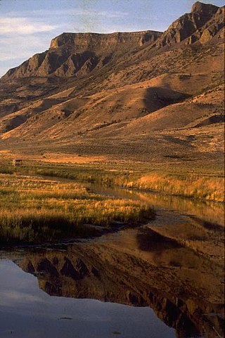
Lake Abert is a large, shallow, alkali lake in Lake County, Oregon, United States. It is approximately 15 mi (24 km) long and 7 mi (11 km) wide at its widest point. It is located 3 mi (4.8 km) northeast of the small, unincorporated community of Valley Falls, Oregon. The lake was named in honor of Colonel John James Abert by explorer John C. Fremont during his 1843 expedition into Central Oregon. No fish live in the alkaline waters of the lake; however, its dense population of brine shrimp supports a variety of shorebirds. The lake is an important stop on the bird migration route known as the Pacific flyway.

<span class="mw-page-title-main">Reub Long</span>

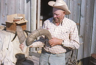
Reuben Aaron Long was an Eastern Oregon rancher, author, and story teller. He was known throughout Oregon as a witty and wise cowboy philosopher. In 1964, he joined E.R. Jackman to write The Oregon Desert, which is still a very popular book fifty years after its original publication.

<span class="mw-page-title-main">Valley Falls, Oregon</span> Unincorporated community in the state of Oregon, United States

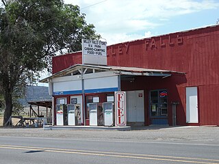
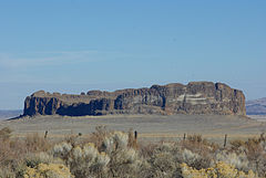
Valley Falls is a small unincorporated community in Lake County, Oregon, United States. The settled area is located at the junction of U.S. Route 395 and Oregon Route 31. The community is named for a small falls on the Chewaucan River just north of the occupied site. East of Valley Falls, the cliff face of Abert Rim overlooks the community.

<span class="mw-page-title-main">Fort Rock Valley Historical Homestead Museum</span>

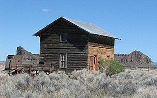
The Fort Rock Valley Historical Homestead Museum is located in Fort Rock, Oregon, United States. Opened in 1988, it is a collection of original homestead-era buildings including a church, school, houses, homestead cabins, and several other buildings assembled in a village setting. The structures were moved to the museum site from various locations around the Fort Rock Valley, named for volcanic landmark Fort Rock. Most of the buildings contain historic items used by local homesteaders including furniture, dishes, household products, and tools. The museum is open for self-guided tours from Memorial Day weekend through Labor Day weekend.

<span class="mw-page-title-main">Camp Warner</span> Former military outpost in Oregon, USA

Camp Warner was a United States Army outpost in south-central Oregon, United States. Camp Warner was located at two different sites approximately 35 miles (56 km) apart. The Army called both sites Camp Warner. However, the first site became known as Old Camp Warner. It was used as winter quarters in 1866–1867 and then abandoned. The second, more developed site is generally known as Fort Warner, although the Army never officially designated it as a fort. Fort Warner was used as a supply depot and administrative headquarters from 1867 to 1874 during a protracted Army campaign against Northern Paiute bands in Eastern Oregon and Northern California. Today, nothing remains of either Old Camp Warner or Fort Warner.

<span class="mw-page-title-main">Warner Valley</span> Valley in south-central Oregon

The Warner Valley is a valley in south-central Oregon in the United States. It is a remote valley at the northwestern corner of North America's Basin and Range Province. The valley is home to a chain of lakes and wetlands known as the Warner Lakes. Native Americans were present in the Warner Valley for thousands of years before European explorers arrived in the 19th century. It is the site of Fort Warner, built by the United States Army in 1867. The fort was used as a supply depot and administrative headquarters during a protracted Army campaign against Northern Paiute bands in eastern Oregon and northern California. Today, livestock ranching is the main commercial activity in the valley. The Warner Valley offers a number of recreational opportunities including hunting, fishing, bird watching, and wildlife viewing.

<span class="mw-page-title-main">Hart Lake (Oregon)</span> Lake of the United States of America

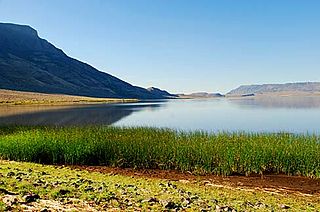
Hart Lake is a shallow lake in the Warner Valley of eastern Lake County, Oregon, United States. The lake covers 7,324 acres (29.64 km2) and has the most stable water level within the valley's Warner Lakes chain. The lake is named for the heart-shaped brand used by the pioneer Wilson and Alexander cattle ranch established near the lake. Much of the land around Hart Lake is administered by the Bureau of Land Management (BLM) and the United States Fish and Wildlife Service (FWS). The lake and the surrounding wetlands support a wide variety of birds and other wildlife. Recreational opportunities on and near Hart Lake include hunting, fishing, bird watching, and boating.

<span class="mw-page-title-main">Goose Lake Valley</span> Valley in south-central Oregon and northeastern California

The Goose Lake Valley is located in south-central Oregon and northeastern California in the United States. It is a high valley at the northwestern corner of North America's Great Basin. Much of the valley floor is covered by Goose Lake, a large endorheic lake that straddles the Oregon–California border. Native Americans inhabited the Goose Lake Valley for thousands of years before explorers arrived in the 19th century. The pioneer wagon route known as the Applegate Trail crossed the Goose Lake Valley on its way to southern Oregon. At the south end of Goose Lake, the Lassen Cutoff separated from the Applegate Trail and headed south toward the Sacramento Valley. Today, Lakeview, Oregon, is the largest settlement in the valley. Livestock ranching and lumber mills are the valley's main commercial activity. The Goose Lake Valley offers a number of recreational opportunities including hang-gliding, hunting, fishing, and birdwatching.

<span class="mw-page-title-main">Ray Hatton</span>

Raymond Robert (Ray) Hatton was an English educator, author, and long-distance runner. Born in England, Hatton moved to the United States in 1956 to attend college, earning degrees in education and geography from University of Idaho and the University of Oregon. He was an award-winning college geography professor for many years. Hatton wrote ten books on Oregon geography, history, and climatology. In the 1970s and 1980s, he won numerous Masters level running championships and set American records in several long-distance running events. Ran a Masters WR in the Mile at 4:26.0 in 1972. Hatton was inducted into the USATF Masters Hall of Fame in 2001.

<span class="mw-page-title-main">Catlow Valley</span> Basin in Oregon, United States

The Catlow Valley is a basin in Harney County, Oregon, United States. It is a remote valley at the northwestern corner of North America's Basin and Range Province. The valley is named after a pioneer rancher, John Catlow. The area was used by Native Americans for thousands of years before European explorers arrived in the 19th century. Today, cattle ranching is the main commercial activity in the valley. The public land in the Catlow Valley is administered by the Bureau of Land Management. This public land offers a number of recreational opportunities including hiking, hunting, fishing, bird watching, and wildlife viewing.

<span class="mw-page-title-main">Fossil Lake (Oregon)</span> Dry lakebed and fossil site in the U.S. state of Oregon

Fossil Lake is a dry lakebed in the remote high desert country of northern Lake County in the U.S. state of Oregon. During the Pleistocene epoch, Fossil Lake and the surrounding basin were covered by an ancient lake. Numerous animals used the lake's resources. Over time, the remains of many of these animals became fossilized in the lake sediments. As a result, Fossil Lake has been an important site for fossil collection and scientific study for well over a century. Over the years, paleontologists have found the fossil remains of numerous mammals as well as bird and fish species there. Some of these fossils are 2 million years old.

<span class="mw-page-title-main">Hager Mountain</span>

Hager Mountain is a volcanic peak in Oregon in the northwest corner of the Basin and Range Province in the United States. The mountain is located south of the small unincorporated community of Silver Lake in south-central Oregon, and it is in the Fremont–Winema National Forest. On the summit, there is a fire lookout operated during the summer and fall by the United States Forest Service. There are several hiking trails that lead to the lookout station.

<span class="mw-page-title-main">Crump Lake (Oregon)</span> Natural lake in Oregon, US

Crump Lake is a shallow lake in the Warner Valley of eastern Lake County, Oregon, United States. The lake covers 7,680 acres (31.1 km2). It is the largest of the Warner Lakes system. The lake is named for pioneer rancher Thomas Crump. Crump Lake is owned by the Oregon Department of State Lands. Much of the land around the lake is administered by the Bureau of Land Management and the United States Fish and Wildlife Service. The lake and the surrounding wetlands support a wide variety of birds and other wildlife. Recreational opportunities on or near Crump Lake include fishing, bird watching, and camping.

<span class="mw-page-title-main">Lava bear</span> Variety of bear in North America

The lava bear is a variety of American black bear found in the lava beds of south central Oregon. The animal was described as a very small bear with wooly light brown fur. The few lava bears that were killed or captured were a little larger than a badger. It was once thought to be a separate species. However, scientists who examined the specimens determined that the animals were stunted due to the harsh environment in which they lived. Today, it is acknowledged that lava bears never existed as a unique species.

<span class="mw-page-title-main">Glass Buttes</span>

Glass Buttes are a group of volcanic mountains made up of two prominent peaks and several smaller hills. They are located in the remote northeast corner of Lake County between Bend and Burns in central Oregon, United States. Raising high above the high desert plain, the buttes are an important landmark in an area once known as the Oregon's Great Sandy Desert. The buttes are named for the numerous large deposits of obsidian found on their slopes. Today, most of the mountains and surrounding land are administered by the Bureau of Land Management. The mountains offer a number of recreational opportunities including rock collecting, hiking, camping, and hunting.

Thorn Lake is a dry high-desert lake in Lake County in the U.S. state of Oregon. The Atlas of Oregon Lakes lists its surface area at about 320 acres (130 ha) and its shoreline at about 4 miles (6.4 km) but provides no other details.

<span class="mw-page-title-main">Stauffer, Oregon</span> Abandoned town in Oregon, United States

Stauffer was an unincorporated community located in Lake County, Oregon, United States. The first homesteaders arrived in the area around 1910. By 1918, the local population was declining rapidly due to the harsh environment. Today, Stauffer is a ghost town with no population and no surviving structures. The site is located approximately 12 miles (19 km) south of U.S. Route 20 between Bend and Burns, Oregon. The nearest inhabited place is Hampton, Oregon, 21 miles (34 km) northwest of the Stauffer site.

<span class="mw-page-title-main">Fleetwood, Oregon</span> Ghost town in Oregon, United States

Fleetwood was an unincorporated community located in Lake County, Oregon, United States. The first homesteaders arrived in the area around Fleetwood in 1905. The Fleetwood post office was opened in 1913. By 1920, the local population was declining due to a severe drought that dried up surface water and lowered the water table in the area around Fleetwood. Today, Fleetwood is a ghost town with no population and no surviving structures at the townsite. The site is located approximately 10 miles (16 km) east of Fort Rock state park. The nearest inhabited place is the small unincorporated community of Fort Rock, Oregon, which is 9 miles (14 km) west of the Fleetwood townsite.

References

  1. 1 2 3 4 McArthur, Lewis A. and Lewis L. McArthur, "Fremont", Oregon Geographic Names (Seventh Edition), Oregon Historical Society Press, Portland, Oregon, 2003, p. 382.
  2. 1 2 3 Hatton, Raymond R., Pioneer Homesteads of the Fort Rock Valley, Binford and Mort, Portland, Oregon, 1981, pp. 18-19.
  3. 1 2 Oregon topographic map, United States Geological Survey, United States Department of Interior, Reston, Virginia; displayed via ACME mapper, www.acme.com, 28 November 2021.
  4. McArthur, Lewis A. and Lewis L. McArthur, "Fort Rock", Oregon Geographic Names (Seventh Edition), Oregon Historical Society Press, Portland, Oregon, 2003, p. 372.
  5. Brogan, Phil F., East of the Cascades, Binford and Mort, Portland, Oregon, 1965, pp. 20-21.
  6. 1 2 Jackman, E.R. and R.A. Long, The Oregon Desert, Caxton Press, Caldwell, Idaho: 1964, pp. 356.
  7. "Hole-in-the-Ground Volcano", Oregon Volcanoes, Deschutes and Ochoco National Forests, United States Forest Service, Bend, Oregon, accessed 31 October 2021.
  8. "Northern Lake Contains Wonder", Lake County Examiner, Lakeview, Oregon, 25 September 1913, p. 1.
  9. Hatton, Raymond R., High Desert of Central Oregon, Binford and Mort, Portland, Oregon, 1981, pp. 7–8, 94.
  10. 1 2 3 Hatton, Raymond R., Pioneer Homesteads of the Fort Rock Valley, Binford and Mort, Portland, Oregon, 1981, pp. 14-15.
  11. 1 2 Jackman, E.R. and R.A. Long, The Oregon Desert, Caxton Press, Caldwell, Idaho: 1964, pp. 34-36.
  12. 1 2 3 Brogan, Phil F., East of the Cascades, Binford and Mort, Portland, Oregon, 1965, pp. 166-167.
  13. 1 2 3 4 Hatton, Raymond R., High Desert of Central Oregon, Binford and Mort, Portland, Oregon, 1981, pp. 101-103.
  14. "Settler Optimistic", Lake County Examiner, Lakeview, Oregon, 12 March 1914, p. 3.
  15. 1 2 Jackman, E.R. and R.A. Long, The Oregon Desert, Caxton Press, Caldwell, Idaho: 1964, p. 321.
  16. Hatton, Raymond R., Pioneer Homesteads of the Fort Rock Valley, Binford and Mort, Portland, Oregon, 1981, pp. 41-42.
  17. "News of the North End", Lake County Examiner, Lakeview, Oregon, 23 April 1914, p. 8.
  18. Hatton, Raymond R., High Desert of Central Oregon, Binford and Mort, Portland, Oregon, 1981, pp. 96-98.
  19. "New District being Opened", Bend Bulletin, Bend, Oregon, 25 August 1909, p. 1.
  20. "Many New Settlers", Lake County Examiner, Lakeview, Oregon, 28 August 1913, p. 1.
  21. "County News", Lake County Examiner, Lakeview, Oregon, 25 March 1909, p. 4.
  22. "North End has a Large Influx", Lake County Examiner, Lakeview, Oregon, 29 February 1912, p. 1.
  23. "Railroads Galore for Lake County", Lake County Examiner, Lakeview, Oregon, 1 February 1912, p. 1.
  24. "Lake County People Taking Interest in Big Campaign for Good Roads", Bend Bulletin, Bend, Oregon, 12 April 1919, p. 7.(subscription required).
  25. 1 2 Hatton, Raymond R., High Desert of Central Oregon, Binford and Mort, Portland, Oregon, 1981, p. 104.
  26. Hatton, Raymond R., High Desert of Central Oregon, Binford and Mort, Portland, Oregon, 1981, p. 106.
  27. "Proclamations", Oregon Daily Journal, Portland, Oregon, 17 June 1921, p. 13.(subscription required).
  28. "Fremont", La Pine Intermountain, La Pine, Oregon, 19 May 1921, p. 4.
  29. B. L. G., "Much of Interest Found to South", Bend Bulletin, Bend, Oregon, 4 May 1923, p. 5.
  30. Hatton, Raymond R., High Desert of Central Oregon, Binford and Mort, Portland, Oregon, 1981, p. 110.
  31. "Fremont 5 NW, Oregon 1981-2010 Monthly Normals" . Retrieved April 27, 2024.
  32. "xmACIS2" . Retrieved April 27, 2024.
  33. "FREMONT 5 NW, OREGON (353095)". Western Regional Climate Center. Retrieved April 27, 2024.