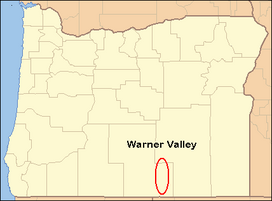
The Warner Valley is a valley in south-central Oregon in the United States. It is a remote valley at the northwestern corner of North America's Basin and Range Province. The valley is home to a chain of lakes and wetlands known as the Warner Lakes. Native Americans were present in the Warner Valley for thousands of years before European explorers arrived in the 19thcentury. It is the site of Fort Warner, built by the United States Army in 1867. The fort was used as a supply depot and administrative headquarters during a protracted Army campaign against Northern Paiute bands in eastern Oregon and northern California. Today, livestock ranching is the main commercial activity in the valley. The Warner Valley offers a number of recreational opportunities including hunting, fishing, bird watching, and wildlife viewing.
The Warner Valley is located in south-central Oregon. It is approximately 60 miles (97km) long and 8 miles (13km) wide. Most of the valley is in Lake County; however, the north end of the valley extends about 10 miles (16km) into Harney County. The valley has two regions commonly referred to as the South Warner Valley and the North Warner Valley. The two areas transition between Crump Lake and Hart Lake at a point where the valley narrows to about 5 miles (8.0km) in width.[1]
Both sides of the South Warner Valley have steep cliffs rising from 1,000 to 2,000 feet (300 to 610m) above the valley floor. The eastern cliffs run the entire length of the valley, while the western wall turns into rolling hills at the north end of the valley. The Coyote Hills are the western boundary through the middle of the North Warner Valley, with the Rabbit Hills bounding the northwest corner of the valley. From the hills, the ground slopes up to the crest of Abert Rim. The eastern boundary of the valley is Hart Mountain, a massive cliff face that rises 3,600 feet (1,100m) above the valley floor. Warner Peak is the highest point on Hart Mountain. The summit is 8,065 feet (2,458m) above sea level.[1][2][3][4]
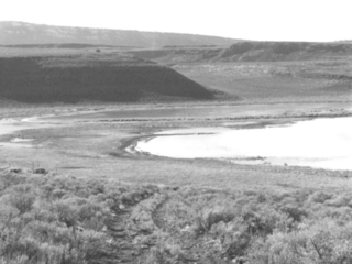
The valley floor is occupied by a chain of lakes known collectively as the Warner Lakes. The entire valley was once covered by a single vast lake; however, the water level gradually receded, leaving a chain of lakes at the low spots with marshland between the lakes. Starting at the south end of the valley, the largest of the Warner Lakes are Pelican Lake, Crump Lake, Hart Lake, Anderson Lake, Swamp Lake, Mugwump Lake, Flagstaff Lake, Upper Campbell Lake, Lower Campbell Lake, Stone Corral Lake, Turpin Lake, and Bluejoint Lake. Because the valley slopes away to the north, Crump Lake is 12 feet (3.7m) higher in elevation than Bluejoint Lake.[1][3][4][5]
Geology
The country to the north and east of the Warner Valley is a high volcanic plateau which has undergone considerable erosion. The Warner Valley was probably a similar high plateau before massive faulting dropped the valley floor and uplifted the land around it, forming high valley walls. The Warner Lakes formed in the valley bottom after the faulting stopped.[6][7]
The Warner Valley is bounded by high escarpment walls on the east and west. The main line of perpendicular displacement is along the foot of the cliffs to the east of the Warner Lakes. This scarp feature is known as Hart Mountain. The main cliff face of Hart Mountain towers 3,600 feet (1,100m) above the valley floor.[3] It runs the length of the valley, eventually being lost in a series of smaller fault scarps at the north end of the valley. These smaller scarps generally run from the east side of the valley to the northwest. The south end of the valley is more complex. In that area, the valley floor is bounded on three sides by perpendicular cliffs from 1,500 to 2,000 feet (460 to 610m) high, the result of numerous fault events. These cliffs expose hundreds of feet of Miocene and Oligocenelava flows and ignimbrites, which include Steens basalt and various andesite, trachyandesite, and tuff flows. The mountain mass forming the western border of the South Warner Valley is a steep fault scarp. This cliff face rises over 2,000 feet (610m) above the valley floor.[6][8]
Warner Valley is an alluvial basin containing numerous lakes, remnants of a single great lake that covered the valley floor up to a depth of 200 feet (61m) during the Pleistocene epoch. Today, steep cliffs rise above a chain of endorheic lakes.[1][7]
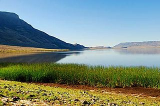
View of the Warner Valley looking west from Hart Mountain
The same view during low water in June 2015. Upper Campbell Lake is to the left, Campbell Lake to the right.
Climate
The climate in the Warner Valley is typical of the high desert country of south-central Oregon. However, the high escarpments forming the western wall of the South Warner Valley tend to protect the southern part of the valley from the prevailing westerly winds. The absence of a high rim along much of the North Warner Valley increases the harshness of the fall and winter seasons at the north end of the valley.[9]
Air movements brought about by the uneven temperatures in the valley and on the surrounding higher plateaus and mountains give rise to local winds. These winds are strongest at places where canyons, such as Deep Creek Canyon, open into the valley.[9]
In the Warner Valley, frost is common until late spring and begins again in early fall. As a result, the growing season in the valley is limited to about 100 days. The Warner Valley gets most of its rain in May and June, while the summer and fall months tend to be very dry. The winter snowfall in the valley bottom is generally very light; however, winter temperatures can get very cold. The higher plateau country above the valley usually gets several feet of snow and the higher peaks can get much more. In most years, the high peaks have snow on them from early fall until mid-summer. This snowpack feeds the streams that drain into the valley.[9]
Ecology
Warner Wetlands Interpretive Site
The Warner Valley provides a number of unique animal habitats. These include lake, marsh, riparian, grasslands, sage steppe, dry forest, and rimrock. They range in elevation from approximately 4,500 feet (1,400m) above sea level at the valley floor to over 8,000 feet (2,400m) at the summit of Warner Peak. Marsh grasses are common along the lake shores. In the riparian areas, wild roses, choke cherry, wild plum, cottonwood, and willow are found. Beyond the wetlands, the valley becomes quite dry. Much of the North Warner Valley is semi-desert, where dwarf sagebrush, greasewood, and Western Juniper are the dominant vegetation.[1][3][10]
The first European explorer to enter the valley was probably John Work, who headed a Hudson's Bay Company trapping expedition in 1832. While it is not certain that he visited the valley, he was in the area and left a description of a "valley of lakes" that correspond closely to the Warner Valley. The next explorer to arrive in the valley was Captain John C. Fremont, who led a party through the valley in December 1843. Fremont named it Christmas Valley since his party spent Christmas Day camped near Hart Lake. However, early mapmakers mistakenly sited Christmas Valley at another location 60 miles (97km) northwest of the Warner Valley, leaving the valley unnamed on an early map.[5]
In 1849, the valley was explored by Captain William H. Warner, an Army topographical engineer. On 26 September 1849, Warner was ambushed and killed by Indians just south of the Warner Valley. In 1864, Lieutenant Colonel C. S. Drew of the 1st Oregon Cavalry visited the valley while on a long-range reconnaissance patrol. Drew named the valley in honor of Warner, who he believed had been killed there.[5]
Oregon Central Military Wagon Road
In 1865, the Army decided it needed a fort in the Warner Valley to facilitate the interdiction of Indian raiding parties passing through the area. Army scouts selected a site along Honey Creek on the west side of the Warner Lakes. In 1866, a detachment from Fort Boise was sent to establish the fort. The soldiers arrived on the east side of the lakes in late summer. Unable to cross the chain of lakes and marshes, the soldiers built a winter camp on the east side of the lakes. The camp was sited poorly and the men had a very difficult winter. In February 1867, General George Crook visited the Warner Valley outpost. Crook directed that the camp be moved to the Honey Creek site west of the lakes. To get the Army’s wagons across the wetlands, Crook ordered the construction of a bridge across the narrow channel between Hart Lake and Crump Lake. Shortly after the bridge was begun a second detachment was sent ahead to build the new fort. The Stone Bridge was completed that summer and the soldiers moved into the new camp, which was named Fort Warner. By 1869, the Indian raids in south-central Oregon had ended and a treaty had been signed. With no Indian raiders left in the area, Fort Warner was abandoned in 1874.[15][16][17] While nothing remains of Fort Warner, the Stone Bridge the Army built to cross the Warner wetlands still exists. The bridge is now listed on the National Register of Historic Places.[15][16][18]
In 1865, the United States Congress authorized the construction of the Oregon Central Military Wagon Road from Eugene, Oregon, to Fort Boise in Idaho. Congress allowed the construction company to claim three sections of land for every mile of road built. As a result, road surveyors laid out a route designed to pass through as much well-watered, desirable land as possible. The route of the military road came through the Warner Valley, crossing over the Warner Lakes at the Stone Bridge before passing south of Hart Mountain through what is today the Hart Mountain National Antelope Refuge and heading east.[15][19][20][21]
In reality, the Oregon Central Military Wagon Road was a venture designed to acquire public lands at little or no cost to the road company’s investors. Nevertheless, the construction company was able to secure thousands of acres of valuable grazing land in the Warner Valley. Legal disputes kept the ownership of these lands in question for decades, preventing settlers from claiming land grants for farms and ranches. Ownership was finally decided by the United States Supreme Court in a case known as the United States versus the California and Oregon Land Company.[20][21][22] Eventually, the land passed into the hands of the Oregon Valley Land Company, which subdivided it into lots and parcels. The property was sold in a nationally advertised auction held in Lakeview, Oregon in 1909.[23]
Settlement did not occur in the Warner Valley until the latter part of the 19thcentury. For example, the land occupied by Fort Warner was homesteaded by John H. Dent in 1889.[24] The Plush, Oregon post office was opened on 18 July 1888. Its first postmaster was David R. Jones.[25] The Adel post office was opened in 1896.[26]
Human activity
Hay stacks in fields south of Adel
Today, agriculture is the primary source of income in the Warner Valley. Most of the private land in the valley is used for cattle ranching. Crops are generally used for winter feed. Because of the short growing season, the valley’s principal crops are wild hay, alfalfa, clover, and timothy-grass. Grains such as wheat, oats, rye, and barley can also be grown in the Warner Valley. Three crops of alfalfa per season can be raised over much of the South Warner Valley, while the less favorable climate in the North Warner Valley makes one or two crops the norm.[1][3]
Much of the valley is public land administered by the Bureau of Land Management. These public lands offer numerous recreational opportunities including hunting, fishing, bird watching, wildlife viewing, boating, and camping. However, some of these activities are dependent on the water level of the Warner Lakes, which can fluctuate dramatically. Crappie, smallmouth bass, and bullhead catfish are common in the lakes while trout including Great Basin redband trout are found in Twentymile Creek, Deep Creek, and Honey Creek. There are no developed campgrounds in the valley; however, dispersed camping is allowed on land administered by the Bureau of Land Management. There are public restrooms, sheltered picnic tables, and hiking trails at the Bureau of Land Management's Warner Wetlands Interpretive Site at Hart Bar.[7][27]
Communities
There are no incorporated cities in Warner Valley. The nearest city is Lakeview, the county seat of Lake County.
Adel is an unincorporated community in the South Warner Valley.[28]
Plush is an unincorporated community in the North Warner Valley.[28]
Lake County is one of the 36 counties in the U.S. state of Oregon. As of the 2020 census, the population was 8,160. Its county seat is Lakeview. The county is named after the many lakes found within its boundaries, including Lake Abert, Summer Lake, Hart Lake, and Goose Lake.
Lakeview is a town in Lake County, Oregon, United States. The population was 2,418 at the 2020 census. It is the county seat of Lake County. The city bills itself as the "Tallest Town in Oregon" because of its elevation, 4,757 feet (1,450 m) above sea level. Lakeview is situated in the Goose Lake Valley at the foot of the Warner Mountains and at the edge of Oregon's high desert country. Its economy is based on agriculture, lumber production, and government activities. In addition, tourism is an increasingly important part of the city's economy. Oregon's Outback Scenic Byway passes through Lakeview.
The Warner Mountains are an 85-mile (137 km)-long mountain range running north–south through northeastern California and extending into southern Oregon in the United States. The range lies within the northwestern corner of the Basin and Range Province, extending from the northeastern corner of Lassen County, California, through eastern Modoc County, California, and northward into Lake County, Oregon.
Adel is an unincorporated community in southeastern Lake County, in the U.S. state of Oregon. The community is in an arid, sparsely populated part of the state, along Oregon Route 140, about 30 miles (48 km) east of Lakeview. The Warner Valley surrounding Adel contains many marshes and shallow lakes, most of them intermittent.
Abert Rim in Lake County, Oregon is one of the highest fault scarps in the United States. It rises 2,490 feet (760 m) above the valley floor, finishing with an 820-foot (250 m) sheer-sided basalt cap. It was formed during the Miocene epoch. At that time basaltic flood lavas covered much of eastern Oregon. In subsequent faulting, great blocks were tilted and Abert Rim is at the western end of one of these blocks, while Lake Abert lies on top of another. Stretching more than 30 miles (48 km) from Lakeview north to Alkali Lake, Abert Rim is also the longest exposed fault scarp in North America.
Hart Mountain is a fault-block mountain, in Lake County, Oregon, U.S. It lies about 30 miles (48 km) to the east of Lakeview.
Plush is an unincorporated rural community and census-designated place in the Warner Valley of Lake County, in the U.S. state of Oregon. As of the 2010 census it had a population of 57. The community is in an arid, sparsely populated part of the state 39 miles (63 km) by road northeast of Lakeview. The valley surrounding Plush contains many marshes and shallow lakes, most of them intermittent.
The Wood River is a short river in the southern region of the U.S. state of Oregon, and part of the Klamath Basin drainage. It flows 18 miles (29 km) through the Fremont-Winema National Forests, Bureau of Land Management land, and private property in southern Oregon. Its watershed consists of 220 square miles (570 km2) of conifer forest, rural pasture land, and marsh. The river provides habitat for many species of wildlife including an adfluvial (migratory) and resident populations of native Great Basin redband trout.
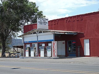
Valley Falls is a small unincorporated community in Lake County, Oregon, United States. The settled area is located at the junction of U.S. Route 395 and Oregon Route 31. The community is named for a small falls on the Chewaucan River just north of the occupied site. East of Valley Falls, the cliff face of Abert Rim overlooks the community.
The Greaser Petroglyph Site is located on land managed by the Bureau of Land Management in eastern Lake County, Oregon. The designs were scraped into a basalt boulder by Native Americans perhaps 12,000 years ago. No one knows the meaning of the designs. Because of its unique archaeological and cultural significance, the Greaser Petroglyph Site was listed on the National Register of Historic Places in 1974.
The Stone Bridge is a causeway built by the United States Army in 1867. It crosses the marshy channel that connects Hart Lake and Crump Lake in a remote area of Lake County in eastern Oregon, United States. It was later incorporated into the Oregon Central Military Wagon Road which was completed in 1872. The wagon road eventually became the subject of scandal and litigation ending with a United States Supreme Court decision in 1893. The Stone Bridge and the Oregon Central Military Wagon Road were listed together on the National Register of Historic Places in 1974. Today, the Stone Bridge is located on land claimed by the State of Oregon under riparian rights. The wagon road adjacent to the Stone Bridge is owned by the United States Government and is administered by Bureau of Land Management.
Camp Warner was a United States Army outpost in south-central Oregon, United States. Camp Warner was located at two different sites approximately 35 miles (56 km) apart. The Army called both sites Camp Warner. However, the first site became known as Old Camp Warner. It was used as winter quarters in 1866–1867 and then abandoned. The second, more developed site is generally known as Fort Warner, although the Army never officially designated it as a fort. Fort Warner was used as a supply depot and administrative headquarters from 1867 to 1874 during a protracted Army campaign against Northern Paiute bands in Eastern Oregon and Northern California. Today, nothing remains of either Old Camp Warner or Fort Warner.
The Warner Lakes are a chain of shallow lakes and marshes in the Warner Valley of eastern Lake County, Oregon, United States. The lakes extend the length of the valley, covering approximately 90,000 acres (360 km2).
Hart Lake is a shallow lake in the Warner Valley of eastern Lake County, Oregon, United States. The lake covers 7,324 acres (29.64 km2) and has the most stable water level within the valley's Warner Lakes chain. The lake is named for the heart-shaped brand used by the pioneer Wilson and Alexander cattle ranch established near the lake. Much of the land around Hart Lake is administered by the Bureau of Land Management (BLM) and the United States Fish and Wildlife Service (FWS). The lake and the surrounding wetlands support a wide variety of birds and other wildlife. Recreational opportunities on and near Hart Lake include hunting, fishing, bird watching, and boating.
The Goose Lake Valley is located in south-central Oregon and northeastern California in the United States. It is a high valley at the northwestern corner of North America's Great Basin. Much of the valley floor is covered by Goose Lake, a large endorheic lake that straddles the Oregon–California border. Native Americans inhabited the Goose Lake Valley for thousands of years before explorers arrived in the 19th century. The pioneer wagon route known as the Applegate Trail crossed the Goose Lake Valley on its way to southern Oregon. At the south end of Goose Lake, the Lassen Cutoff separated from the Applegate Trail and headed south toward the Sacramento Valley. Today, Lakeview, Oregon, is the largest settlement in the valley. Livestock ranching and lumber mills are the valley's main commercial activity. The Goose Lake Valley offers a number of recreational opportunities including hang-gliding, hunting, fishing, and birdwatching.
The David L. Shirk Ranch is a historic ranch located in the Guano Valley of eastern Lake County, Oregon, United States. The ranch was originally homesteaded in 1881. It was purchased by David L. Shirk in 1883. He operated the ranch until 1914. The property was acquired by the United States Government in 1942. The ranch is now administered by the Bureau of Land Management. The remaining historic ranch buildings are listed on the National Register of Historic Places.
The Picture Rock Pass Petroglyphs Site is in northern Lake County, Oregon, United States. The site is located near the summit of Picture Rock Pass on land administered by the Bureau of Land Management. The designs were scraped into a basalt boulder by ancient Native Americans, probably between 7,500 and 12,000 years ago. No one knows the meaning of the petroglyph designs. Because of its unique archaeological and cultural significance, the Picture Rock Pass Petroglyph Site was listed on the National Register of Historic Places in 1975.
The Catlow Valley is a basin in Harney County, Oregon, United States. It is a remote valley at the northwestern corner of North America's Basin and Range Province. The valley is named after a pioneer rancher, John Catlow. The area was used by Native Americans for thousands of years before European explorers arrived in the 19th century. Today, cattle ranching is the main commercial activity in the valley. The public land in the Catlow Valley is administered by the Bureau of Land Management. This public land offers a number of recreational opportunities including hiking, hunting, fishing, bird watching, and wildlife viewing.
Fossil Lake is a dry lakebed in the remote high desert country of northern Lake County in the U.S. state of Oregon. During the Pleistocene epoch, Fossil Lake and the surrounding basin were covered by an ancient lake. Numerous animals used the lake resources. Over time, the remains of many of these animals became fossilized in the lake sediments. As a result, Fossil Lake has been an important site for fossil collection and scientific study for well over a century. Over the years, paleontologists have found the fossil remains of numerous mammals as well as bird and fish species there. Some of these fossils are 2 million years old.
Crump Lake is a shallow lake in the Warner Valley of eastern Lake County, Oregon, United States. The lake covers 7,680 acres (31.1 km2). It is the largest of the Warner Lakes system. The lake is named for pioneer rancher Thomas Crump. Crump Lake is owned by the Oregon Department of State Lands. Much of the land around the lake is administered by the Bureau of Land Management and the United States Fish and Wildlife Service. The lake and the surrounding wetlands support a wide variety of birds and other wildlife. Recreational opportunities on or near Crump Lake include fishing, bird watching, and camping.
References
1 2 3 4 5 6 Whistler, John T. and John H. Lewis, "Location and General Conditions", Warner Valley and White River Projects, United States Reclamation Service, United States Department of Interior in cooperation with the State of Oregon, Washington D.C., February 1916, pp. 16–19.
↑ McArthur, Lewis A. and Lewis L. McArthur, "Hart Mountain", Oregon Geographic Names (Seventh Edition), Oregon Historical Society Press, Portland, Oregon, 2003, p. 449.
1 2 Whistler, John T. and John H. Lewis, "Geology", Warner Valley and White River Projects, United States Reclamation Service, United States Department of Interior in cooperation with the State of Oregon, Washington D.C., February 1916, p. 21.
1 2 3 Whistler, John T. and John H. Lewis, "Climate", Warner Valley and White River Projects, United States Reclamation Service, United States Department of Interior in cooperation with the State of Oregon, Washington D.C., February 1916, p. 20.
↑ "Warner Wetlands", Welcome to Lake County, Oregon’s Outback, OregonsOutback.com, Lakeview, Oregon, 12 October 2009.
↑ "Cultural Resources" (PDF), Summary of the Analysis of the Management Situation for the Lakeview Resource Area – Resource Management Plan, Lakeview Field Office, Lakeview District, Bureau of Land Management, United States Department of Interior, Lakeview, Oregon, July 2000, pp. 2.28–29.
↑ "Greaser Petroglyph, OR", Waymarking (posted by Volcanoguy), Groundspeak Inc., www.waymarking.com, 16 October 2007.
↑ "Greaser Petroglyph Site", National Register of Historic Places, www.nationalregisterofhistoricalplaces.com, 19 January 2009.
1 2 3 "Stone Bridge and the Oregon Central Military Wagon Road", National Register of Historic Places Inventory – Nomination Form, National Register of Historic Places, United States Park Service, United States Department of Interior, Washington, D.C., 13 August 1974.
↑ Bach, Melva M., "Camp Warner Moved to Honey Creek – 1867" (PDF), History of the Fremont National Forest, Fremont National Forest, United States Forest Service, United States Department of Agriculture, Lakeview, Oregon, 1981, p. 14.
↑ "Oregon Central Military Road", Oregon State Office, Bureau of Land Management, United States Department of Interior, Portland, Oregon, 17 September 2009.
This page is based on this Wikipedia article Text is available under the CC BY-SA 4.0 license; additional terms may apply. Images, videos and audio are available under their respective licenses.