
Petroglyph National Monument stretches 17 miles (27 km) along Albuquerque, New Mexico's West Mesa, a volcanic basalt escarpment that dominates the city's western horizon. Authorized June 27, 1990, the 7,236 acre (29.28 km2) monument is cooperatively managed by the National Park Service and the City of Albuquerque. The western boundary of the monument features a chain of dormant fissure volcanoes. Beginning in the northwest corner, Butte volcano is followed to its south by Bond, Vulcan, Black and JA volcanoes.

The Morley Nelson Snake River Birds of Prey National Conservation Area has one of the densest populations of nesting raptors. The National Conservation Area (NCA) is located 35 miles (56 km) south of Boise, Idaho along 81 miles (130 km) of the Snake River, and is managed by the Bureau of Land Management. The NCA covers 484,873 acres (1,962.21 km2). In descending order of land area it is located in Ada, Elmore, Owyhee, and Canyon counties.

Canyons of the Ancients National Monument is a national monument protecting an archaeologically significant landscape located in the southwestern region of the U.S. state of Colorado. The monument's 176,056 acres (71,247 ha) are managed by the Bureau of Land Management, as directed in the presidential proclamation which created the site on June 9, 2000. Canyons of the Ancients National Monument is part of the National Landscape Conservation System, better known as the National Conservation Lands. This system comprises 32 million acres managed by the Bureau of Land Management to conserve, protect, and restore these nationally significant landscapes recognized for their outstanding cultural, ecological, and scientific values. Canyons of the Ancients encompasses and surrounds three of the four separate sections of Hovenweep National Monument, which is administered by the National Park Service. The monument was proclaimed in order to preserve the largest concentration of archaeological sites in the United States, primarily Ancestral Puebloan ruins. As of 2022, over 8,500 individual archeological sites had been documented within the monument.

Malheur National Wildlife Refuge is a National Wildlife Refuge located roughly 30 miles (48 km) south of the city of Burns in Oregon's Harney Basin. Administered by the United States Fish and Wildlife Service, the refuge area is roughly T-shaped with the southernmost base at Frenchglen, the northeast section at Malheur Lake and the northwest section at Harney Lake.

Plush is an unincorporated rural community and census-designated place in the Warner Valley of Lake County, in the U.S. state of Oregon. As of the 2010 census it had a population of 57. The community is in an arid, sparsely populated part of the state 39 miles (63 km) by road northeast of Lakeview. The valley surrounding Plush contains many marshes and shallow lakes, most of them intermittent.

Coso Rock Art District is a rock art site containing over 100,000 Petroglyphs by Paleo-Indians and/or Native Americans. The district is located near the towns of China Lake and Ridgecrest, California. Big and Little Petroglyph Canyons were declared a National Historic Landmark in 1964. In 2001, they were incorporated into this larger National Historic Landmark District. There are several other distinct canyons in the Coso Rock Art District besides the Big and Little Petroglyph Canyons. Also known as Little Petroglyph Canyon and Sand Tanks, Renegade Canyon is but one of several major canyons in the Coso Range, each hosting thousands of petroglyphs. The majority of the Coso Range images fall into one of six categories: bighorn sheep, entopic images, anthropomorphic or human-like figures, other animals, weapons & tools, and "medicine bag" images. Scholars have proposed a few potential interpretations of this rock art. The most prevalent of these interpretations is that they could have been used for rituals associated with hunting.
The Oregon high desert is a region of the U.S. state of Oregon located east of the Cascade Range and south of the Blue Mountains, in the central and eastern parts of the state. Divided into a southern region and a northern region, the desert covers most of five Oregon counties and averages 4,000 feet (1,200 m) above sea level. The southwest region is part of the Great Basin and the southeast is the lower Owyhee River watershed. The northern region is part of the Columbia Plateau, where higher levels of rainfall allow the largest industry on private land to be the cultivation of alfalfa and hay. Public land within the region is owned primarily by the Bureau of Land Management, which manages more than 30,000 square miles (78,000 km2) including five rivers designated as Wild and Scenic.
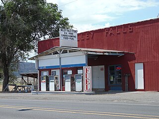
Valley Falls is a small unincorporated community in Lake County, Oregon, United States. The settled area is located at the junction of U.S. Route 395 and Oregon Route 31. The community is named for a small falls on the Chewaucan River just north of the occupied site. East of Valley Falls, the cliff face of Abert Rim overlooks the community.

The Painted Rock Petroglyph Site is a collection of hundreds of ancient petroglyphs near the town of Theba, Arizona, United States, listed on the National Register of Historic Places in 1977. The site is operated and maintained by the Bureau of Land Management (BLM), and includes an improved campground as well as an informative walking trail showcasing the petroglyphs.

The Barnesville Petroglyph petroglyph site in the eastern part of the U.S. state of Ohio. Located approximately 3 miles (4.8 km) southwest of the village of Barnesville in Belmont County, the petroglyphs have been known both by archaeologists and the general public since the 1850s or earlier. Although the site was significantly damaged during the twentieth century, it is still a significant archaeological site, and has been named a historic site.
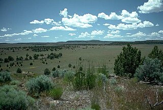
The Warner Valley is a valley in south-central Oregon in the United States. It is a remote valley at the northwestern corner of North America's Basin and Range Province. The valley is home to a chain of lakes and wetlands known as the Warner Lakes. Native Americans were present in the Warner Valley for thousands of years before European explorers arrived in the 19th century. It is the site of Fort Warner, built by the United States Army in 1867. The fort was used as a supply depot and administrative headquarters during a protracted Army campaign against Northern Paiute bands in eastern Oregon and northern California. Today, livestock ranching is the main commercial activity in the valley. The Warner Valley offers a number of recreational opportunities including hunting, fishing, bird watching, and wildlife viewing.

The Warner Lakes are a chain of shallow lakes and marshes in the Warner Valley of eastern Lake County, Oregon, United States. The lakes extend the length of the valley, covering approximately 90,000 acres (360 km2).
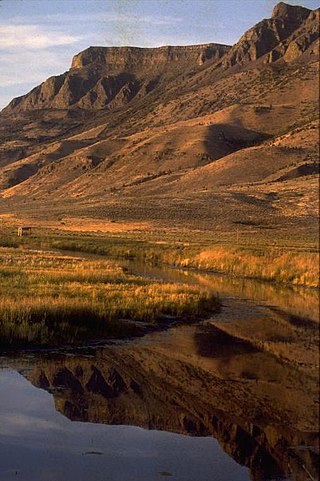
Hart Lake is a shallow lake in the Warner Valley of eastern Lake County, Oregon, United States. The lake covers 7,324 acres (29.64 km2) and has the most stable water level within the valley's Warner Lakes chain. The lake is named for the heart-shaped brand used by the pioneer Wilson and Alexander cattle ranch established near the lake. Much of the land around Hart Lake is administered by the Bureau of Land Management (BLM) and the United States Fish and Wildlife Service (FWS). The lake and the surrounding wetlands support a wide variety of birds and other wildlife. Recreational opportunities on and near Hart Lake include hunting, fishing, bird watching, and boating.

Judaculla Rock is a curvilinear-shaped outcrop of soapstone known for its ancient carvings and petroglyphs. The archaeological site is located on a 0.85-acre rectangular-shaped property, now owned by Jackson County. It is approximately 60 meters east of Caney Fork Creek, a major branch of the northwestward-trending Tuckasegee River in the mountains of Western North Carolina.
Petroglyph Canyon (24CB601) is an archaeologically significant canyon in the northwestern United States. Located on both sides of the border between Montana and Wyoming, the canyon has long been obscure due to its small size. However, it gained substantial attention in the late 20th century because of its numerous prehistoric petroglyphs, and much of it was named a historic site in the 1970s.

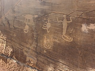
The Picture Rock Pass Petroglyphs Site is in northern Lake County, Oregon, United States. The site is located near the summit of Picture Rock Pass on land administered by the Bureau of Land Management. The designs were scraped into a basalt boulder by ancient Native Americans, probably between 7,500 and 12,000 years ago. No one knows the meaning of the petroglyph designs. Because of its unique archaeological and cultural significance, the Picture Rock Pass Petroglyph Site was listed on the National Register of Historic Places in 1975.

The Deer Valley Petroglyph Preserve, formerly known as the Deer Valley Rock Art Center, is a 47-acre nature preserve featuring over 1500 Hohokam, Patayan, and Archaic petroglyphs visible on 500 basalt boulders in the Deer Valley area of Phoenix, Arizona. In 1980, the US Army Corps of Engineers contracted Simon J. Bruder to conduct an archaeological investigation prior to the construction of the Adobe Dam at the Hedgpeth Hills. The petroglyphs are between 500 and 5,000 years old. The site was listed on the National Register of Historic Places in 1984, and it was also listed with the Phoenix Points of Pride. The preserve and museum are operated by the ASU College of Liberal Arts and Sciences's School of Human Evolution and Social Change.

The Abert Lake Petroglyphs are a prehistoric archaeological site in Lake County, Oregon, United States. Peoples of the Great Basin cultural tradition pecked the images onto two basaltic boulders near major game migration routes. They are believed to be connected with rituals related to hunting activities, and contribute to the larger understanding of subsistence patterns in the northern Great Basin. They were made within the last 10,000 years, but their age cannot be stated more precisely due to the difficulty of dating petroglyphs.

The East Lake Abert Archeological District is an area in Lake County, Oregon, United States, that features numerous prehistoric camp sites and petroglyphs. It is located along the eastern shore of Lake Abert on land administered by the Bureau of Land Management and the Oregon Department of Transportation. The site includes stone-walled house pits and prehistoric rock art made by ancient Native Americans who occupied the site for approximately 11,000 years. Because of its unique archaeological and cultural significance, the East Lake Abert Archaeological District was listed on the National Register of Historic Places in 1978.

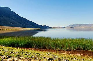
Crump Lake is a shallow lake in the Warner Valley of eastern Lake County, Oregon, United States. The lake covers 7,680 acres (31.1 km2). It is the largest of the Warner Lakes system. The lake is named for pioneer rancher Thomas Crump. Crump Lake is owned by the Oregon Department of State Lands. Much of the land around the lake is administered by the Bureau of Land Management and the United States Fish and Wildlife Service. The lake and the surrounding wetlands support a wide variety of birds and other wildlife. Recreational opportunities on or near Crump Lake include fishing, bird watching, and camping.


