National Register of Historic Places listings in Union County, Oregon
Last updated
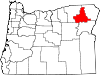
Location of Union County in Oregon
This list presents the full set of buildings, structures, objects, sites, or districts designated on the National Register of Historic Places in Union County, Oregon, and offers brief descriptive information about each of them. The National Register recognizes places of national, state, or local historic significance across the United States.[1] Out of over 90,000 National Register sites nationwide,[2]Oregon is home to over 2,000,[3] and 20 of those are found in Union County.
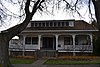
This fine French Second Empire house represents a style unusual in Eastern Oregon. It was built ca. 1900[lower-alpha 1] for Abel Eaton, a prosperous businessman, civic leader, and mayor. It stands in the north Union neighborhood that was the town's upscale residential area during its period of rapid growth in the late 19th and early 20th centuries.[7][8]
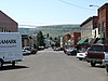
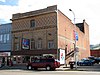
The buildings of Union's downtown core and oldest residential neighborhoods recall the town's long and vitalizing, but ultimately unsuccessful, rivalry in the late 19th century with nearby La Grande to lead Union County in transportation, commerce, population, and government. Significant structures include many from Union's period of rapid growth from its early years through World War I (1870–1919), and a smaller number from the decades just after the town reached its zenith (1920–1940).[8]
↑ Oregon Parks and Recreation Department, Oregon Historic Sites Database, retrieved August 6, 2015. Note that a simple count of National Register records in this database returns a slightly higher total than actual listings, due to duplicate records. A close reading of detailed query results is necessary to arrive at the precise count.
1 2 Numbers represent an alphabetical ordering by significant words. Various colorings, defined here, differentiate National Historic Landmarks and historic districts from other NRHP buildings, structures, sites or objects.
↑ The eight-digit number below each date is the number assigned to each location in the National Register Information System database, which can be viewed by clicking the number.
This page is based on this Wikipedia article Text is available under the CC BY-SA 4.0 license; additional terms may apply. Images, videos and audio are available under their respective licenses.